
The New York City Public Library is expanding geographical knowledge and experiences with its new online map warping tool with access to over 10,000 historical maps of the city as well as hundreds of other places.
In the spring of 2014, the New York Public Library (NYPL) announced that it had completely digitized its map collection, allowing users access to them from its website. Moreover, users also have the ability to edit the old maps and superimpose them on top of modern maps of the city.
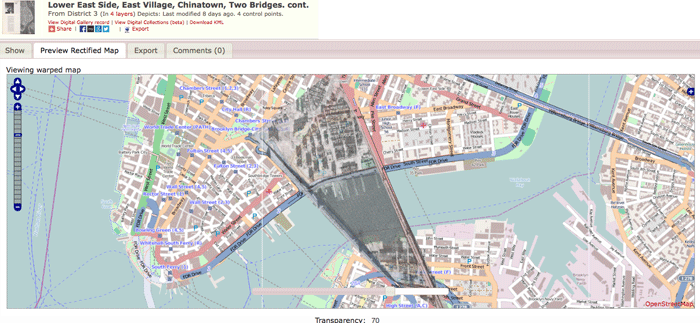
The best part of using this map warping tool is that the superimposed, or rectified, maps show how specific places have changed over time. For example, users can see how an area on a historical map made up of buildings is now a park or how much Manhattan has expanded out into the bay over time. They can then fly around those creations from the comfort of their own computers.
This project uses the open source Map Warper tool to rectified and warp the scanned maps onto a web map display using OpenStreetMap.
The map collection accessible online is made up of almost all of its New York City atlases that are under a Creative Commons public domain license. Besides over 1,000 maps of New York’s boroughs and neighborhoods dating from 1660 to 1922, the digital map collection includes:
- Over 10,000 property, zoning, and topographic maps of New York City from 1852 to 1922. These also come from fire insurance atlases.
- 1,100 maps of mid-Atlantic regions and cities dating back to the 16th century. Many of these are drawn from the Lawrence H. Slaughter Collection.
- 2,800 maps from state, county and city atlases from New York and New Jersey.
- Over 700 topographic maps of the Austro-Hungarian Empire produced between 1877 and 1914.
This is the first time that most of the NYPL maps have been made available online. It took a team of over 1,500 staff, volunteers, and interns across the globe to complete the project.

To access the maps and make use of the tool, all individuals have to do is point their browsers to the NYPL Map Warper. From there, it is easy to search for, view, and download maps from the collection.
In order to overlay and edit maps, however, users must create an account. Editing maps via the warping tool enables them to produce ones that are precisely aligned with real spatial coordinates and save them for others to browse.

The maps and warping tool are generating significant excitement from both professional and amateur geographers alike. There is a huge potential in terms of what people are able to create for academic as well as artistic purposes.
Moreover, the New York City Public Library is hoping to expand the project in different ways. They want to eventually create a historic online directory of New York City that includes everything from historical store prices to restaurant menus.
By rebuilding these old places in virtual place, the NYPL is going a long way to preserve history but also make it fun for others.
Scratch Off 1924 New York to Reveal the Modern City
What lies beneath 1924 New York City? Chris Whong has created a fun online mapping application, called Urban Scratchoff, that lets users “scratch off” the 1924 aerial overlay to reveal modern New York underneath.
Navigate around the map either by typing in an address to zoom to or by panning and zooming to a desired location. Click the Scratchoff button and simply start scrubbing the area with your cursor to reveal the underlying aerial. The 1924 and current day aerials can be flipped to get the reverse effect.

The 1924 aerial comes from the New York Public Library’s aerial imagery collection and the current day aerials are from Mapquest’s OpenAerial tiles. The code for the map hack is available on github.
Whong has a short write up about developing Urban Scratchoff and his inspiration for doing so, writing:
“The idea popped into my head that it would be really interesting to “erase” the pre-BQE blocks on a historic photo to reveal the modern highway and get a better idea of the cost of progress.
To be honest, it reminded me of SimCity, where you can demolish whole swaths of land with a click of a mouse. This would be much more than just comparing two aerial images of the same place… it would let the user choose an area to explore, and reveal the differences at their own speed, based on their own curiosity.”
References
“Exploring New York City’s Past with Library Maps.” http://blogs.wsj.com/metropolis/2014/04/04/exploring-new-york-citys-past-with-library-maps/
“Do the timewarp across New York: Library puts 10,000 historic maps of the five boroughs online and lets users ‘warp’ them onto modern maps.” http://www.dailymail.co.uk/sciencetech/article-2594652/Do-timewarp-New-York-Library-puts-10-000-historic-maps-five-boroughs-online-lets-users-warp-modern-maps.html
“New York Public Library now lets you use 20,000 historical maps for free.” http://www.engadget.com/2014/03/31/new-york-public-library-free-maps/
Related Articles about Mapping New York City
- A New Tool to Develop Visions for an Ecologically Sustainable New York City
- Uber Residential Pick-Ups in New York City Reflect Demographic Realities
- Mapping Urban Trees and Income in Manhattan