
historical maps

Medieval Peutinger Map | Book Review
The Peutinger Map (Tabula Peutingeriana) is a unique medieval replica of a Roman route map from the late fourth to early fifth centuries.
![[Map of California shown as an island], Joan Vinckeboon, ca. 1650.](https://www.geographyrealm.com/wp-content/uploads/2021/08/map-california-island-1650-Vinckeboons.jpg)
California as an Island
Well into the 17th and 18th centuries, cartographers created maps of the region showing California separated from the mainland by a strait.

What Was the First Map Issued by the Ordnance Survey?
The first Ordnance Survey map was issued in 1801.


Over 600 Maps Added to South Dakota Digital Archives
The South Dakota State Historical Society has made over 600 maps available online with the South Dakota Digital Archives.

Visit Almost Four Hundred Years of Mapping Inner Earth With this Virtual Map Exhibit
This virtual exhibit shows different theories and maps that have been created postulating what Earth’s interior looks like throughout history and showed evolution of our ideas of what lies beneath our feet.
Early Data Visualization Pioneers
RJ Andrews created DataViz based on his collected notes to provide readers with insight into five of the earlier pioneers of data visualization.

Color to Your Heart’s Delight With These Historical Map Coloring Pages
Relax and reduce your stress by printing out and coloring in these maps.
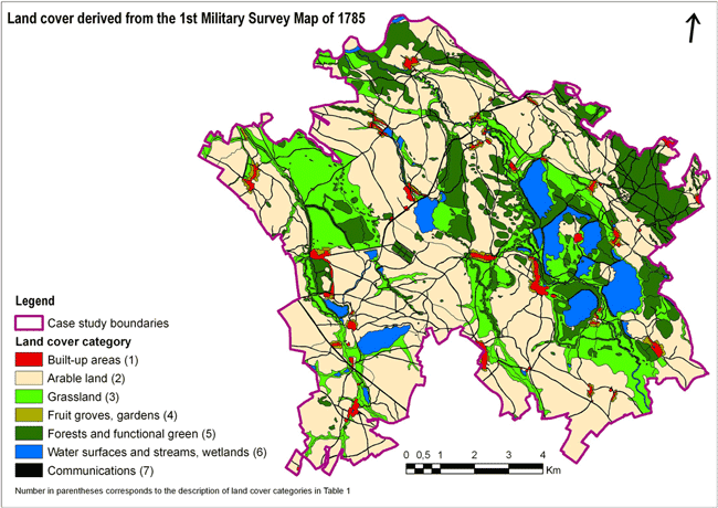
GIS and Modern Research from Historical Maps
While GIS offers a way to digitize detailed historical records and maps, it can also provide a new way to understand history and trends over time.
Dissected Maps: the First Jigsaw Puzzles
The earliest jigsaw puzzles were created as educational tools. Known as "dissected maps" these early puzzles were used to teach geography.

Travel through Time with New York City’s Maps
The New York City Public Library introduces an online map warping tool, offering access to over 10,000 historical maps of the city.

Where to Look for Historical Maps
The use of extracting data from old paper maps is growing in popularity as a method to understanding historical geography. ...
Best of GIS: Notable 2011 Geospatial Happenings
It’s been a very long time since I’ve done a “best of GIS” year end review. Listed below are ...
Over 120 Years of Mapping History Online
The USGS Historical Topographic Map Collection currently makes over 98,000 maps dating as far back as 1884 available to the public.