
“Power of the Past – Progress of the Future”.
This theme of the just concluded 2014 National Tribal GIS Conference hosted in Albuquerque (November 3rd – 7th), aptly denotes the essence of Geospatial application amongst Native Americans. The 5th National Tribal GIS Conference in the U.S. was also a celebration of how convergence of history and technology can usher in a tide of change.
“As some of the earliest adopters of geographic information system (GIS) technology, Native American tribal governments have used GIS to support thousands of programs and initiatives”. [Jack Dangermond, President, ESRI, in his foreword to the book: Tribal GIS – Supporting Native American Decision Making]
Native Americans have incorporated GIS programs for protection of heritage and environment, economic development, education, community health, transportation, land use, natural resources management and Tribal Governance – along a continuous trajectory over time.
Cast Studies and Best Practices
GIS usage amongst Native Americans has occurred across diverse projects, outreach programs and governance, within a single comprehensive platform. Listed below are some case studies that have been recognized for their remarkable contribution to various aspects of tribal governance and community outreach.
Preservation of Tribal Culture and History
Preservation of cultural heritage has been a primary concern of Native Americans, especially because of geographic displacements and relocations over the centuries. The Chicksaw Nation and Seminole are amongst the many tribes that have been using GIS to preserve tribal history, culture and heritage. As part of the programs led by the Chickasaw Nation GeoSpatial Information Department, Chicksaw Nation has maintained enhanced databases and maps related to history and culture, amongst other areas pertinent to the community.
In collaboration with the Seminole Tribal Historic Preservation Office (THPO), the Seminole Tribes have extensively documented historic structures, archaeological sites and traditional cultural properties leveraging archaeometry. Techniques used were historical mapping, Remote Sensing, Ground Penetrating Radar (for detection of sub-surface features), on-the-fly surveys using ArcPad and survey grade GPS – for integration into the geographically referenced Seminole Site File (SSF) database.
This project entitled, “Using GIS as a Tool for Tribal Historic Preservation Offices“, was honored with the Esri Special Achievement Award, 2008, for its methodology in documenting, and preserving the Seminole cultural heritage.

Education
The tool of GIS has also been used to aid the decision support system (DSS) of community educational programs. Initiatives taken by schools of the Alamo Navajo and Santa Fe community have used GIS to research various areas of ecological importance like water quality, agriculture and environmental issues, adding fillip to the geospatially enabled tribal programs..
Community mapping, GIS workshops and internships, research grants, TGISC collaborative websites like the Tribal GIS; are other ways of outreach that are benefitting the tribal government leaderships.
Transportation
American Indians in their capacity of sovereign nations, manage all aspects of tribal governance, of which transport is a major thrust area. GIS is used to inventory reservation roads, maintain transport infrastructure and more importantly predict network response times for efficient routes and emergency services like the Navajo Roadway Inventory System.
Economic Development on Tribal Lands
Native Americans have autonomous rights over their lands which are governed by legislative frameworks. As stakeholders of the land, they have been using various GIS tools since the 1990s for mapping, managing, monitoring and preserving their lands. The first step was integrating spatial data related to historical land ownership. This facilitated parcel ownership mapping, settlement of boundary disputes, transfers to federal status for privileges and designing of effective land-use planning. Various projects have used the geospatial platform to identify parcels for development programs, leverage the federal program of reverting reservation land to tribal ownership, for activities related to residential land-use, ingress issues, zoning ordinances, rights-of-way and business licensing for efficient urban development. Online centralized databases managed by tribal governments have enabled geo-processing and analysis for various land-use issues. Tribes like the Navajo Nation have used GIS technology to face challenges of parcel ownership where land holdings are highly fragmented, to establish grazing lands and land use for community centers – setting a case in point of geospatial application by Native Americans.
Managing the Environment
Various initiatives of tribal communities across the U.S. have incorporated the knowledge of tribal leaders into a GIS framework to better manage the environment and natural resources. Multiple layers of information across critical areas are being mapped and spatially analyzed for inter-relationships, to preserve the natural wealth.
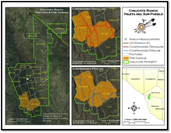
The Tigua Reservation has adopted a dedicated GIS program to manage natural resources. It works in tandem with community outreach progemans to integrate GIS capabilities in workflows across various departments. The Siletz Tribe has applied GIS tools to develop a baseline of three-tiered protection areas, for effective protection of critical wildlife habitat. The Confederated Tribes of Grand Ronde have shared their story of how they use enterprise GIS approach for forest management and environment protection strategies; in particular, for holistic timber use and sale.

Benefitting Indigenous People and Tribes Across the World
Increased representation of tribal projects in GIS conferences and exchange of Tribal GIS know-how between nations, can enable indigenous communities across the world to prosper and compete in a world platform.
Native American and GIS Resources
- Free Software and Training through Bureau of Indian Affairs
- Tribal GIS Groups
- Tribal GIS Papers
- Indigenous Mapping Network
- Aboriginal Mapping Network
- Data Sources – Northwest Tribal Emergency Management Council
- TribalGIS – Best Practices and Standards for Geographic Information Systems within Indian Country
- US Department of the Interior Indian Affairs- Office of Trust Services Geospatial Support (OTSGS)
Grants
Grants and Financial Assistance
Administration for Native Americans
ESRI GIS & Grants >Indigenous Groups
ESRI Conservation Program (ECP) Grants: ECP GIS Grant Guidelines
Southwestern Indian Polytechnic Institute
References
Tribal GIS – Supporting Native American Decision Making [An Esri Publication]
Tribal GIS – Web Portal for “Best Practices and Standards for Geographic Information Systems within Indian Country”
Conservation GIS – The Esri Conservation Program: Tribal and Indigenous People’s GIS