
Generally, research in human evolution has been about finding ancient fossils to demonstrate where different hominid species evolved and when. GIS, however, has now provided new avenues of research that has helped physical anthropologists better understand how different hominid species evolve to different environments.Some research has simply began to map regions’ geology, which can inform on the likelihood of finding relevant fossils from periods of interest; this includes digitizing existing maps but also utilizing multispectral imagery such as Landsat or the ASTER system.[1]
More recent studies have applied more analytical capabilities of GIS, including studying wear analysis on stone tools of modern chimpanzees to better understand how tools were used by hominid ancestors. In this study, an automatic morphometric GIS classification was used to study wear marks made by chimpanzees; inference gained was then used to help interpret ancient tools recovered and what they may have been used for.[2]
Evolutionary models applied in spatial tools have also been utilized to look at evolutionary possibilities. This gives insight as to what pathways of evolution likely led to given species to become more prominent. Looking at factors such as range shifts and contractions, sex-biased dispersal, and mixture of populations has allowed spatial simulations to address possible factors that influence human development.[3]
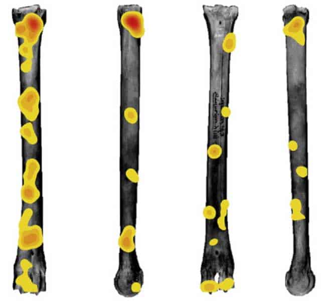
Other recent applications of GIS within the study of human evolution have included the study of tooth markings on patterns of bones, where different patterns can be attributed to different hominids. Spatial point pattern analyses can be used within GIS to indicate where distribution of tooth marks are evident on bone. The analysis provides a taphonomic analysis for hominid species, showing how they exploited meat, where meat played an important role in the development of the hominid brain and growth of hominid species.[4]

References
[1] For an example and review of mapping relevant geological features for study in human evolution using satellite imagery, see: Anemone, R.L., G.C. Conroy, and C.W. Emerson. 2011. “GIS and Paleoanthropology: Incorporating New Approaches from the Geospatial Sciences in the Analysis of Primate and Human Evolution.” American Journal of Physical Anthropology 146 (S53): 19–46. doi:10.1002/ajpa.21609.
[2] For more on analysis of tools and wear marks using GIS and classification techniques, see: Benito-Calvo, Alfonso, Susana Carvalho, Adrian Arroyo, Tetsuro Matsuzawa, and Ignacio de la Torre. 2015. “First GIS Analysis of Modern Stone Tools Used by Wild Chimpanzees (Pan Troglodytes Verus) in Bossou, Guinea, West Africa.” Edited by Elsa Addessi. PLOS ONE 10 (3): e0121613. doi:10.1371/journal.pone.0121613.
[3] For more on the recent use of spatial simulations to understand human evolution, see: Benguigui, Macarena, and Miguel Arenas. 2014. “Spatial and Temporal Simulation of Human Evolution. Methods, Frameworks and Applications.” Current Genomics 15 (4): 245–55.
[4] For more on the use of spatial analysis on tooth marks, see: Parkinson, Jennifer A., Thomas W. Plummer, and Rebecca Bose. 2014. “A GIS-Based Approach to Documenting Large Canid Damage to Bones.” Palaeogeography, Palaeoclimatology, Palaeoecology 409 (September): 57–71. doi:10.1016/j.palaeo.2014.04.019.