
Hydrology
Hydrology is a branch of geography that studies the properties of water on Earth, especially its movement in relation to land.

Largest Alpine Lake in North America
Located in the Sierra Nevada mountain range, Lake Tahoe is a freshwater lake that straddles the border between California and Nevada.

Rivers in the United States are Changing Colors
A team of researchers analyzed Landsat images over a 38-year period and found that a significant number of large U.S. rivers are changing colors.

South America’s Only Natural Oasis
Located in the sand dunes in southwestern Peru on edge of the Atacama desert is the only natural oasis in the continent of South America.

The Sea of Galilee’s Water Levels are on the Rise
Heavy rains have helped the water level in the Sea of Galilee to rebound.

Five Tropical Cyclones in the Atlantic Basin
There are currently five tropical cyclones active in the Atlantic Basin.

Satellite Imagery of the Widest River in the World
The Copernicus Sentinel-1 mission captured this satellite image of the Amazon river that has been processed by the combining of two polarisations into one image.

Hurricane Laura Made This River Flow Backwards Temporarily
When Hurricane Laura came onshore near Texas and Louisiana, its winds were so strong that it pushed the waters of the River Neches backwards for about 12 hours.

Find Your Way Downstream with Streamer
Water is essential for life on the planet, and tool from the U.S. Geological Survey (USGS) makes it easy and fun ...

Sunny Day Flooding is Increasing
Research has shown that the instances of tidal flooding have increased on the Atlantic, Pacific, and Gulf coasts of the United States.

How New York City is Protecting Its Subway System Against Flooding
A flex-gate is a highly flexible covering that can be quickly deployed to protect a subway's entrance and underground structures in the event of a flood.

More Frequent and Intense Tropical Storms Can Change the Geography and Ecology of Coastlines
UNC researchers studied North Carolina tropical cyclones over 120 years.

Geography Facts About the Amazon River
The Amazon River is one of the world's longest and largest rivers. Here are some interesting geographical facts about the Amazon River.

Atmospheric Rivers
Atmospheric Rivers are trails of moisture in the atmosphere composed of condensed water vapor.

Geography Facts About the Mississippi Watershed
The Mississippi watershed is the largest drainage basin in North America.

Earth from Above: Green River
An astronaut aboard the International Space Station captured a segment of the river around Boxknot Bend just north of Canyonlands National Park.

Debris from the 2011 Japanese Tsunami Carried Almost 300 Marine Species Across the Pacific Ocean
A group of researchers inventoried what marine species traveled across the Pacific Ocean between 2012 and 2017 as the result of a biological rafting event created by the 2011 Japanese Tsunami.

Geography Mnemonics to Help Learn About the Great Lakes
Learning the names of the Great Lakes can be aided through the use of mnemonics, a learning device that uses patterns to help with recall.
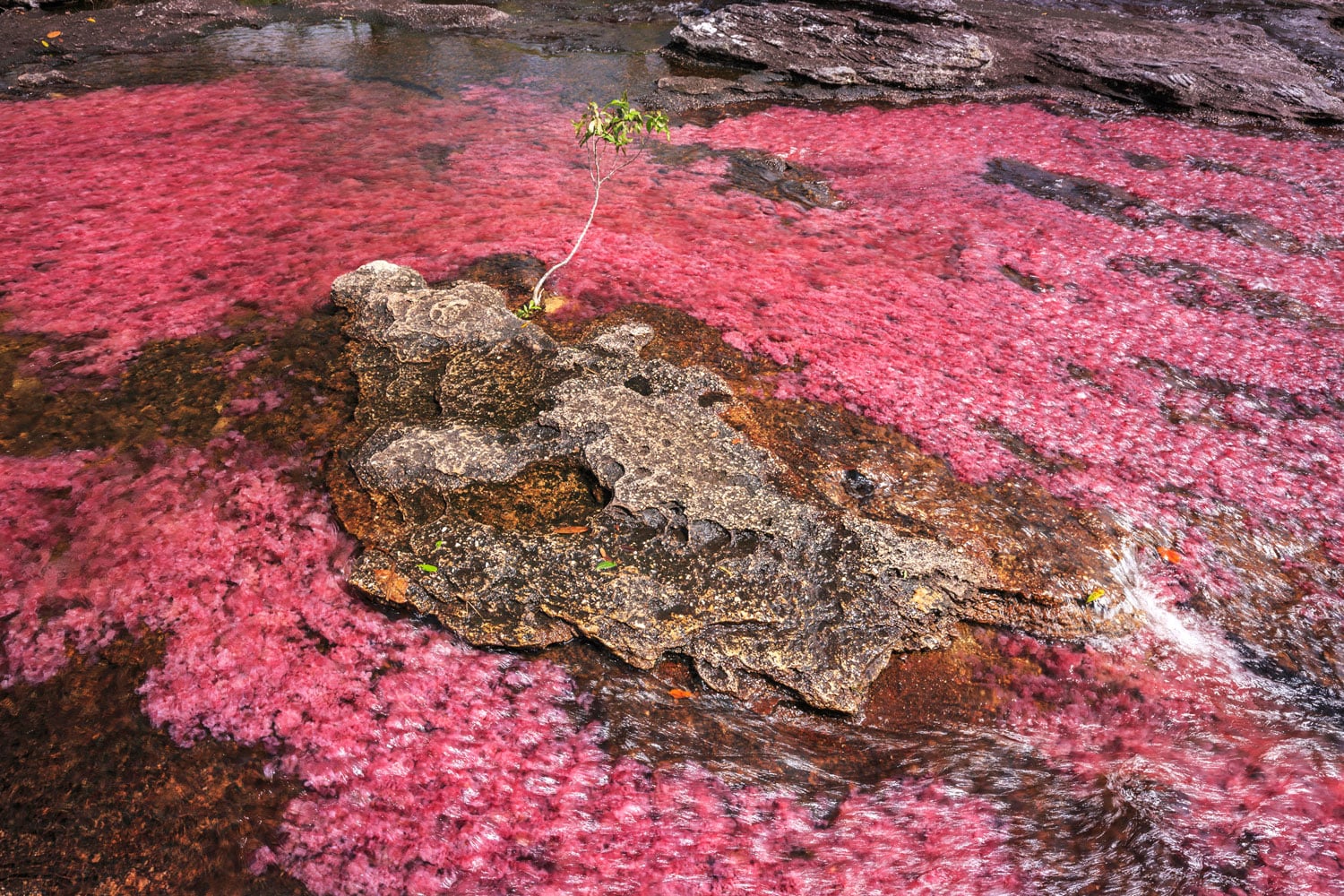
Caño Cristales, the Rainbow River
Caño Cristales, Colombia's River of Five Colors, is famous for its vibrant hues created by the aquatic plant Macarenia clavigera.

Cartography of an Oregon River
Dan Coe used a geospatial technology called LiDAR to map changes in the flow of the Willamette River in Oregon.

The Only Sea in the World Without a Coast
The Sargasso Sea is a "sea within a sea" with no land boundaries.


Why Does Finland Have So Many Lakes?
Finland, with over 187,000 estimated lakes, is known as the "Land of a Thousand Lakes".

Lake Extremes
What are the world's largest freshwater lake, the world’s largest saltwater lake, the world’s deepest freshwater lake, the highest navigable lake, and the saltiest lake?

How Many Lakes are There in the World?
Using high-resolution satellite images, researchers created the GLObal WAter BOdies database (GLOWABO), which includes all lakes larger than 0.002 km2.

Aral Sea Continues to Shrink
Once the fourth-largest inland water body in the world, the Aral Sea shrank again in 2013

Where is the Only Area in Europe Where no Borders Exist?
Lake Constance's shoreline touches three different countries: Germany to the north, Switzerland to the south and Austria at its eastern end. The water body itself contains no borders since there is no legally binding agreement between the three countries.