
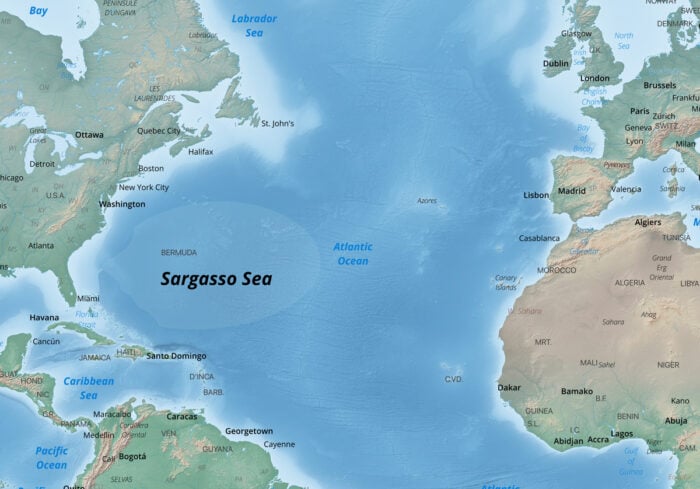
Found in the middle of the Northern Atlantic Subtropical Gyre (a gyre is a large system of rotating ocean currents) near the Bermuda Islands, the Sargasso Sea is surrounded on all cardinal directions by ocean currents.
The Only Sea Without a Land Boundary
The only sea on Earth without a land boundary, the Sargasso Sea is bounded to the west by the Gulf Stream; on the north, by the North Atlantic Current; on the east, by the Canary Current; and on the south, by the North Atlantic Equatorial Current.

About 1,107 km wide and 3,200 km long, the actual boundaries of the sea vary and roughly correlate with the Azores High Pressure Center.
A Holopelagic Specie
Named after the free-floating seaweed genus called Sargassum, the Sargasso Sea is home to a high diversity of marine animals such as white marlin, porbeagle shark, and dolphinfish that use the algae for food and shelter.
The Sargasso Sea is home to many migratory fish species, turtles, and crabs.
Sargassum are holopelagic, which means that this seaweed reproduces vegetatively as it floats in the ocean unlike other seaweeds which reproduce and start their lives on the ocean floor.
Where Does the Word Sargasso Come From?
Both Sargassum and Sargasso originate from the Portuguese word “sargaço” meaning grape. The seaweed was named by 15th century Portuguese explorers who thought the air bladders of the Sargassum looked like the fruit.
First Map to Show the Sargasso Sea

L’Amerique Septentrionale published in 1700 by Guillaume De L’Isle is the first map to show the Sargasso Sea. While not named, the Sargasso Sea is showing with the text “herbes flotante sur la mer” which translates to “grass floating on the sea”.

References
Ardron, J., Halpin, P., Roberts, J., Cleary, J., Moffitt, R., & Donnelly, B. (2011). Where is the Sargasso Sea. Sargasso Sea Alliance Science Report Series, 24. http://www.sargassoseacommission.org/storage/documents/No2_WhereistheSS_LO.pdf
Septentrionalis Map Exhibit. (n.d.). Maine.gov. https://www.maine.gov/sos/arc/collections/septentrionalis.html