
Researchers have officially declared the presence of El Niño on June 8, 2023 after three years of La Niña conditions known as a triple dip.
El Niño conditions are marked by higher than usual temperatures in the tropical Pacific Ocean’s surface, which often results in colder and more humid weather in the U.S. Southwest, while leading to dry spells in the western Pacific region.
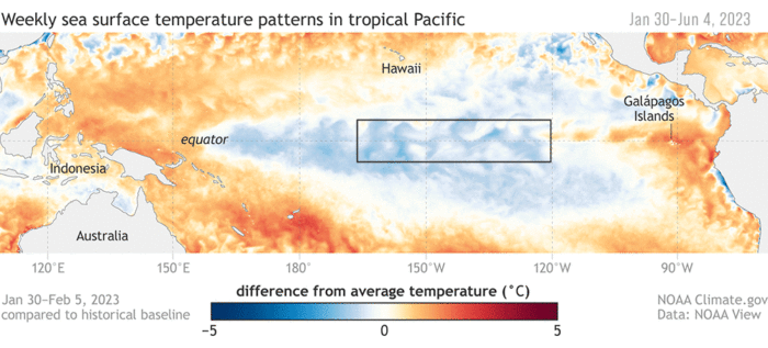
During El Niño, the Pacific Ocean experiences an unusual warming trend in its equatorial waters. This climate phenomenon affects weather patterns globally, causing floods in some regions and droughts in others.
In May 2023, the sea surface temperatures in the Niño 3.4 region of the tropical Pacific, spanning from 170° to 120° West longitude, were reported by NOAA to be 0.8°C (1.4°F) higher than the long-term average. NOAA is also predicting that El Niño conditions will continue to gradually strengthen into the Northern Hemisphere winter 2023-24.

What is El Niño?
El Niño, Spanish for ‘the little boy,’ was named by Peruvian fishers in the 19th century, referencing its frequent occurrence around Christmas. El Niño is a natural phenomenon that emerges from the interaction between the ocean and the atmosphere.
Scientifically termed as El Niño Southern Oscillation (ENSO), it occurs when there is a rise in the sea-surface temperatures across the central and eastern Pacific Ocean, coupled with a decrease in the strength of the trade winds. This happens irregularly, approximately every two to seven years, and lasts from nine months to two years.

Ordinarily, trade winds blow from east to west across the tropical Pacific, pushing warm surface waters towards the Western Pacific. However, during an El Niño event, the trade winds weaken or even reverse, causing the warm water to shift eastwards, suppressing the usual upwelling off South America.
During normal conditions, the Walker Circulation circulates air from the eastern Pacific, where cool surface waters are found, to the western Pacific, where warm surface waters prevail.

During El Niño events, the typical east-west trade winds weaken, disrupting the Walker Circulation. This weakening occurs due to the warming of the central and eastern equatorial Pacific Ocean, which accompanies an El Niño.
As the trade winds decrease in strength, less warm surface water is pushed westward, and less cold water upwells along the South American coast. This creates a ‘pile-up’ of warm water near Indonesia and Australia. Meanwhile, colder, nutrient-rich waters upwell along the South American coast. This disrupts the normal pressure gradient across the Pacific and alters the Walker Circulation.

This redistribution of heat alters the atmospheric circulation patterns and has far-reaching consequences for weather patterns worldwide.
El Niño teleconnections
The warming of the Pacific Ocean triggers atmospheric changes that influence weather patterns around the globe. This cascade of effects is known as teleconnections because the affected changes in weather patterns as a result of El Niño happen far away.
Regions such as western South America and the Southern United States can expect higher rainfall levels, leading to floods and landslides. Conversely, countries like India, Indonesia, and Australia often face droughts due to decreased rainfall. The impacts of El Niño are complex and multifaceted, varying with each occurrence.
References
Hansen, K. (2023, June 21). El Nino returns. NASA Earth Observatory. https://earthobservatory.nasa.gov/images/151481/el-nino-returns
Moore, J. (2023, June 8). NOAA declares the arrival of El Nino. National Weather Service. https://www.weather.gov/news/230706-ElNino