
These maps listed below are the first known maps to record a specific geography, name, or geographical phenomena.
First Map of a Hurricane
National Geographic was the first to create a map of a hurricane. Volume II of the 1890 National Geographic magazine published a map showing the surface wind circulation of the Cuban Hurricane between September 3 and 5, 1888.
Hurricane San Gil was a category 3 hurricane that killed hundreds of people when it made landfall in Cuba.

First Map to Show a Separate Western Hemisphere and Pacific Ocean
Martin Waldseemüller’s 1507 world map was an attempt to document and update new geographic knowledge obtained from late fifteenth- and early sixteenth-century discoveries. Waldseemüller’s map of the world is a composite of twelve separate sheets printed from woodcut blocks. It is believed that originally 1,000 copies were printed but only one copy is known to have survived of the first edition.
The large map is the first to show a separate Western Hemisphere and to show the Pacific Ocean as a distinct ocean. Waldseemüller’s map is also the first known map to document the name America.

More about the Waldseemueller Map:
Geography Realm is a participant in the Amazon Services LLC Associates Program, an affiliate advertising program designed to provide a means for sites to earn advertising fees by advertising and linking to amazon.com.
- The map that changed the world
- The Fourth Part of the World – Book by Tony Lester
- Announcement of the Library of Congress acquiring the Waldseemueller Map of 1507
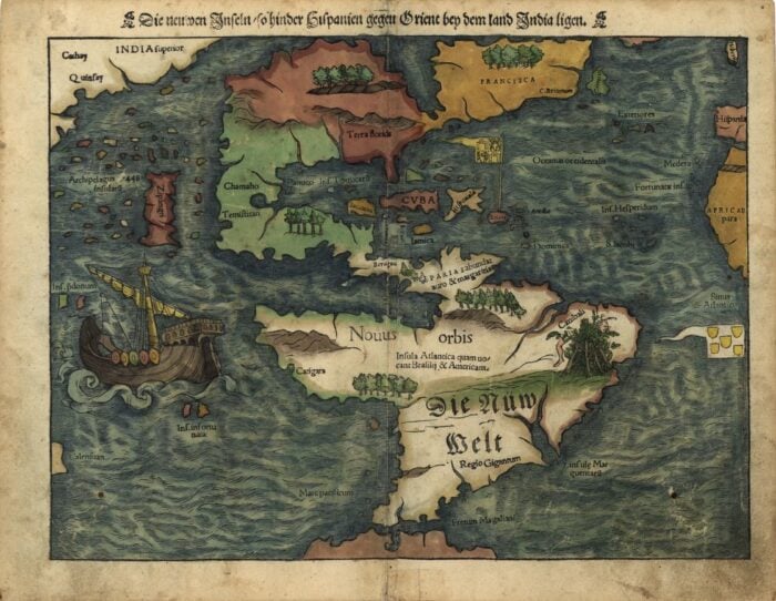
First Map to Show the Americas as a Continent
“Die neuwen Inseln, so hinder Hispanien gegen Orient bey dem land India ligen” is a woodcut map created by German cartographer Sebastian Münster who used it in his Geographia Universalis in 1540, a new edition of Ptolemys Geographia.
The map of the Western Hemisphere is the first map to show North and South America as a continent.
The map is also the first map to label Mare pacificum (the Pacific Ocean).
On the map, South America is labeled in German while all the other features are labeled in Latin.

First Use of the Everglades on a Map of Florida

The first use of the term “Everglades” appeared on a map published in 1823. Spelled as two separate words, ever glades, this is the first English language reference the the large wetland area found in southern Florida.
The text on the map reads, “Extensive inundated Region with Pine and Hummock Islands, of all sizes, and generally called THE EVER GLADES”.

First Map from the UK Ordnance Survey
On June 21, 1791, the Ordnance Survey was created as the United Kingdom’s mapping agency. The first map created by the Ordnance Survey was “An Entirely New & Accurate Survey Of The County Of Kent, With Part Of The County Of Essex,” published in 1801 by Captain William Mudge (1762-1820), a military surveyor.
More: What Was the First Map Issued by the Ordnance Survey?

First Published Map of Wales
Humphrey Llwyd (1527–1568) was a Welsh cartographer who published the first map specifically of Wales in 1573. More: First Published Map of Wales

References
Munster: Die neuwen Inseln, so hinder Hispanien, America continent, 1540. (n.d.). Götzfried Antique Maps. https://www.vintage-maps.com/en/antique-maps/america/america-continent/muenster-america-continent-1540-1550::12468
Strochlic, N. (2018, September 12). How National Geographic has mapped hurricanes over 130 years. National Geographic. https://www.nationalgeographic.com/culture/article/hurricane-weather-maps-science-cartography-history
Waldseemuller map, 1507 (Geography and map reading room, Library of Congress). (n.d.). Library of Congress. https://www.loc.gov/rr/geogmap/waldexh.html