Ground Movement in Norway

By: Caitlin Dempsey

Last updated:

Norway recently released the InSAR Norway portal, a web mapping application where users can see Interferometric Synthetic Aperture Radar (also known as InSAR) data showing areas where the ground is either moving up, known as uplift, or down, known as subsidence (see: Mapping Where Norway is Moving).  Data from InSAR Norway has helped the  Geological Survey of Norway learn where there are areas of significant ground movement in both natural and urban areas of Norway.

Osmundneset

The Hyefjorden (also called Hyenfjord) is a 14 km long fjord arm of the Nordfjord. Found on the east side of Hyenfjord, the mountainside of Osmundneset was found through analyzing the InSAR data to be highly fractured.  An area about one kilometer long is currently moving at the rate of 0.5 centimeters per year.

InSAR data for Osmundneset. Blue are areas with no movement, yellow and red points are areas that are moving about 0.5 cm/year. Source: Geological Survey of Norway.

Rolla Island

Rolla is an island in Troms, Norway that is roughly 106 kilometers in area.  Brustinden at the southern part of the island is currently experiencing ground movement at the rate of around 2 cm/year.

InSAR data for Rolla island. Blue are areas with no movement, yellow and red points are areas that are moving about 2 cm/year. Source: Geological Survey of Norway.

Bjørvika

Bjørvika is an area in Oslo situated in an inlet in the inner Oslofjord.  Bjørvika has been transforming from a container port with urban redevelopment.  Analysis of InSAR data between 2009 and 2018 shows that the area is experiencing one centimeter per year of subsidence.
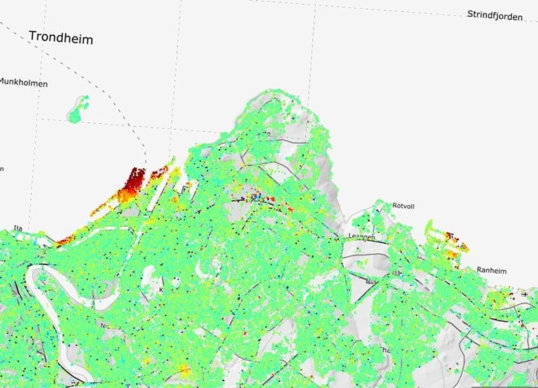
InSAR data for the Bjørvika area in Oslo. Blue are areas with no movement, yellow and red points are areas that are moving about 1 cm/year. Source: Geological Survey of Norway.
InSAR data for the Bjørvika area in Oslo. Green are areas with no movement, yellow and red points are areas that are moving about 1 cm/year. Source: Geological Survey of Norway.

Trondheim

Trondheim is a city located in Trøndelag county, Norway.  The third most populous city in Norway, Trondheim, the harbor area was built on man-made land fillings.  The areas has experienced submarine landslides with the land sinking 2 centimeters per year along the harbor and one centimeter per year in the residential areas.


InSAR data for the Trondheim harbor area. Green are areas with no movement, yellow and red points are areas that are moving about 1 cm/year in the residential areas and 2 cm/year along the harbor. Source: Geological Survey of Norway.

See Also

Photo of author
Caitlin Dempsey
Caitlin Dempsey is a geographer, writer, and the founder and editor of Geography Realm. She holds bachelor's and master's degrees in Geography from the University of California, Los Angeles (UCLA), as well as a Master of Library and Information Science (MLIS) from San José State University. She has been writing about geography, maps, geographic information systems (GIS), and environmental topics for more than two decades through Geography Realm and its predecessor site, GIS Lounge. Her interests include cartography, remote sensing, environmental geography, and the relationship between people and place.