
The only known planet that supports life, Planet Earth stands alone in our universe. Over the decades, the geography of the Earth has been captured by astronauts and spacecraft from space.
As satellite imagery and photography have improved, view of Earth from near space have become sharper and more detailed. Technology has enabled spacecraft to captured images of Earth from the Mars and the outer solar system.
First Global Composite View of Earth – 1965
450 satellite photos were assembled from then recently launched Television Infrared Observation Satellite (TIROS-IX) in 1965. The resulting composite was the first such assembled global image of the Earth created from satellite imagery. The assembled image shows the Earth’s cloud cover as it was on February 13, 1965.

First Color Image of Earth from Space
On July 1, 1967, the Department of Defense Gravitational Experiment (DODGE) satellite was launched with a mission to conduct gravity-gradient stabilization experiments from a near-geostationary orbit.
On September 20, 1967, a black and white 22° field-of-view TV camera took three separate photos of the Earth 18,000 miles from space: one with a red, one with a green, and the third with a blue filter (Mobley, 1968 and Schenkel, 1967).
The combined images created the first color image of the Earth from space. More: The First Color Images of the Earth from Space

Earth Viewed by Apollo 8 – 1968
Astronauts onboard Apollo 8 in late December 1968 captured this view of Earth. The view shows much of the Western Hemisphere with clouds cover much of North America to the north while the southeastern US coastline and the Florida peninsula are visible.
All of South America can be seen in this photo of Earth although most of the continent is shrouded in clouds except for a strip of the Atacama Desert. In the upper right, a small section of western Africa can bee seen.

A couple days later, astronauts captured a black and while picture of Earth as Apollo 8 orbited the Moon. The surface of the Moon can be seen in the foreground.
The Overview Effect
Frank White coined the term, “The Overview Effect” to describe the shift in perspective that many astronauts experiencing when viewing the Earth from space for the first time.
“The vast loneliness up here of the Moon is awe inspiring, and it makes you realize just what you have back there on Earth. The Earth from here is a grand oasis to the big vastness of space.”
— Apollo 8 astronaut Jim Lovell

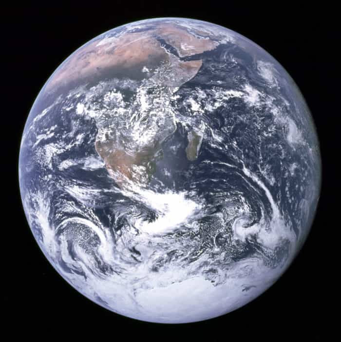
Blue Marble – the Most Distributed Photo of Earth – 1972
One of the most iconic views of the Earth from space is the famous “Blue Marble” photograph. Captured on December 7, 1972 by the crew onboard the Apollo 17 spacecraft from 29,000 kilometers (18,000 miles) away, it remains one of the most reproduced photographs in history. The image is particularly captivating as it was taken with the illumination of the sun behind the Earth.
The original photograph shows the Earth with the South Pole at the top of the image. The photograph captured a view of Africa, Antarctica, and the Arabian Peninsula. The 1972 Tamil Nadu cyclone, which has brought flooding and high winds to India on December 5, can be seen in the bottom left of the image.

The image that is commonly circulated has been cropped with the Earth at the center. The image was also rotated to align with people’s understanding of the position of the Earth with north towards the top.

Earth Moon Composite – 1992
In 1992 Galileo spacecraft captured separate images of the Earth and its moon which were combined for this composite image. A partial image of the Earth with a view of the Pacific Ocean centered about latitude 20 degrees south.
To the west, the coast of South America can be seen along with storm patterns over the southeast Pacific ocean.
The background image was taken of the Moon and shows the Tycho impact basin.

First View of Earth from Another Planet – 2003
This image of the Earth and the Moon was the first photograph taken of Earth from another planet. The image was captured from Mars by the Mars Global Surveyor (MGS) on May 8, 2003.

View from Saturn – 2013
The rings of Saturn can been seen in this view of Earth captured by NASA’s Cassini spacecraft on July 19, 2013. The image was captured 1.45 billion kilometers (898 million miles) away from Earth. This picture of Earth was only the third-ever image of Earth from the outer solar system.

Consider again that dot. That’s here, that’s home, that’s us. On it everyone you love, everyone you know, everyone you ever heard of, every human being who ever was, lived out their lives.
Carl Sagan, Pale Blue Dot: A Vision of the Human Future in Space, 1994
Earth as Seen by NASA’s Mars Rover – 2014
NASA’s Curiosity rover aimed its Mast Camera towards the horizon to capture this image of Earth. Earth is barely visible as a small dot of light seen in the top-center-left of this photo taken on January 31, 2014.

Moon Transiting the Earth – 2015
A NASA camera aboard the Deep Space Climate Observatory (DSCOVR) captured this view of the Moon transiting the Earth on July 16, 2015. The satellite orbits orbits about 1.6 million kilometers (1 million miles) from Earth. Hurricane Dolores can be seen swirling in this image.

View of Earth From the International Space Station
Images of Earth are continuously being captured by astronauts onboard the International Space Station.
For more imagery from the International Space Station watch this video: Views over the Earth

Further Resources
Carlowicz, M. (2015, April 22). Global views of our planet, then and now. NASA Earth Observatory. https://earthobservatory.nasa.gov/images/85736/global-views-of-our-planet-then-and-now
Carlowicz, M. (2018, December 24). All of you on the good earth. NASA Earth Observatory. https://earthobservatory.nasa.gov/images/144427/all-of-you-on-the-good-earth
Earth and moon as seen from Mars. (2008, March 3). NASA Jet Propulsion Laboratory (JPL) – Robotic Space Exploration. https://www.jpl.nasa.gov/images/earth-and-moon-as-seen-from-mars
Gutro, R., & Carlowicz, M. (2015, August 6). The dark side and the bright side. NASA Earth Observatory. https://earthobservatory.nasa.gov/images/86353/the-dark-side-and-the-bright-side
NASA Mars Rover curiosity sees ‘Evening star’ earth. (2014, February 6). NASA Jet Propulsion Laboratory (JPL) – Robotic Space Exploration. https://www.jpl.nasa.gov/news/nasa-mars-rover-curiosity-sees-evening-star-earth
Riebeek, H. (2008, November 27). Earth viewed by Apollo 8. NASA Earth Observatory. https://earthobservatory.nasa.gov/images/36019/earth-viewed-by-apollo-8
Rieebeek, H. (2015, April 22). Global views of our planet, then and now. NASA Earth Observatory. https://earthobservatory.nasa.gov/images/85736/global-views-of-our-planet-then-and-now