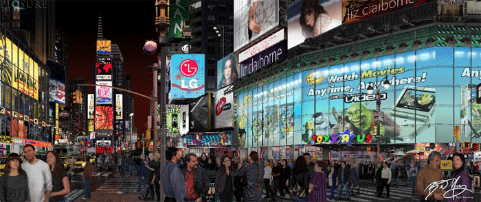
As a geographer and photographer, I am always interested in the intersection of art and geography. Many artists rely on digital images and maps of places they may not have ever seen, or visited only once.
Digital Photo-Realist Artist
Bert Monroy is a digital photo-realist artist based in Berkeley, CA. A lifelong artist who has always been at the forefront of digital technology, his first introduction to Macintosh computers led him to a lifelong love of digital artistry.
An accomplished author and instructor, you can find him on Lynda.com for his weekly podcast “Pixel Playground”, as well as several classes on a variety of topics . His newest work “Amsterdam Mist” was recently revealed at the AdobeMAX conference with a new technology that allows for viewers to peel away the layers of mist as they zoom in on the image.
Using Google Street View in Art
Bert was kind enough to speak with me about this piece as well as his previously released “Times Square” , and how he used Google Street View to create this amazing work of art. You can watch how he used Google Street View for the research of Amsterdam Mist.
For comparison, I asked Bert about his use of Google Street View for Times Square, which he started in 2006, and his latest piece.
In 2010, Bert unveiled his piece “Times Square”, a 60” x 300” piece created with almost 15,000 Adobe Photoshop and Illustrator files. The image took 4 years to complete and 7 visits to New York for reference photos. For this digital painting, Bert started using Street View for perspectives, angles and details, but relied heavily on his own photo studies he had completed during his several visits. He also utilized Google Maps and Google earth for aerial imagery and street layout information. However, Google Street View was limited and he only used it when he was not able to make a trip back to New York.
Kristina Jacob (KJ): How many times did you have to go to Times Square to be able to take pictures for references?
Bert Monroy (BM): Seven different times over the course of the four years. Every time I went to New York I did seven different studies. I would go make a list of what I needed and then when I visited New York I would make a point to be in New York Time Square.
I would use the aerials from Google maps to see the layout of Times Square, and used Street View some to be able to see details when I couldn’t get to New York and to see the perspective of the buildings.

KJ: How many times did you visit Amsterdam to create “Amsterdam Mist”?
BM: I was there once and took a photograph, it’s the first painting that was inspired by the photograph — usually I am inspired by the place.
I would just use Street View to get the details of the buildings I needed and I would look at it from different angles, zoom in on how the door looks and that kind of stuff; so I got all of the photo study done in Street View.
In Amsterdam I completely relied totally 100% on Street View because I had no other reference other than the original shot. That was completely fuzzy I couldn’t really see anything because it was foggy and there was overcast and so I didn’t get that much details.

KJ: How did you decide to use Street View?
BM: Well my wife used Street View to plan out our trip. We would have land maps and would take notes of landmarks so that we would know exactly where we are at all times. So she was really into Street View and I have been using it a lot of myself just to see different things and places.
Once I knew where I was I just walked up and down the Street View and just looked at that lamp post and that sign and what that sign said and stuff like that. So it made it really easy, now it was four hours because the bicycles, the cars, the trucks, everything had to be fairly accurate. So I did research European trucks, European bicycles, that’s European bicycle German one and used those for reference. And the bicycles in front of course were from the photograph, I can tell what those looked like. I also did studies on what the trees looked like because I wasn’t there. I wanted to know how the stones looked like, how did the branches break off and so stuff like that so that everything looked right.
KJ: Did you know that you were utilizing the intersection of geography and art?
BM: Yes I did, I really did. I thought that Times Square as well because of the fact that it encompasses such a large part of the city and it is all in detail. This was one of the first paintings to take on such an expansive part of the city.
KJ: What is the next location?
BM: I have a few locations in mind, but I am thinking of a piece from Rome.
Thanks to Bert for the insight into how he uses geography to help him with his works of art.
More About Kristina Jacob: Meet a Geographer: Kristina Jacob
