
aerial imagery

GIS 101: Learn About GIS
This GIS 101 page is the launch page for accessing information about GIS and geospatial technologies on GIS Lounge.

The Many Uses of Aerial Imagery
Nearmap's Tony Agresta outlines the many applications of aerial imagery, including assessing damage after a disaster, reducing crime, valuing properties, and more.

2018 NAIP Imagery
Aerial imagery covering 20 states has been added to the USDA's direct access site for NAIP imagery.

Before There Were Drones: Using Pigeons for Aerial Photography
Back before drones became a cheap and easy way to acquire aerial imagery, a German inventor proposed using pigeons to capture photographs of the earth from above.

NOAA Offers Post-Hurricane Aerial Imagery
NOAA has been capturing aerial imagery showing the post-Hurricane Michael destruction across the Florida Panhandle.

What Imagery Source is Best for Your Business?
Erin Jepperson, Technical Sales Engineer at Nearmap, outlines how to weigh the pros and cons of aerial imagery and drone imagery.
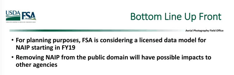
NAIP Aerial Imagery Might be Moved from the Public Domain to a Licensing Model
The Farm Service Agency (FSA) is considering moving its National Agriculture Imagery Program (NAIP) from a free aerial imagery service to a licensing model starting the 2019 fiscal year.

Grassroots Aerial Mapping
Aerial imagery has evolved into a more complex and sophisticated enterprise with most aerial imagery today being captured by aircraft ...
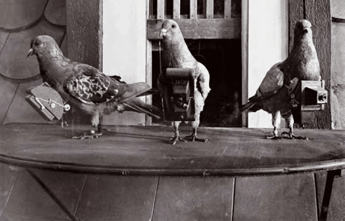
Aerial Mapping with Balloons, Kites, and Pigeons
While aerial photography today is most commonly captured via an airplane fitted with cameras, aerial imagery in the past required more inventiveness with photographers using balloons, kites, and pigeons.
Using Near-Infrared Aerial Imagery to Map Oak Trees
The GIS group for the City of Santa Clarita used 4-inch near-infrared aerial imagery to map specific oak tree species across the city.
Orthophotos and GIS
Aerial photographs play an important role in GIS data acquisition and visualization. First, they help provide a solid visual effect. ...