

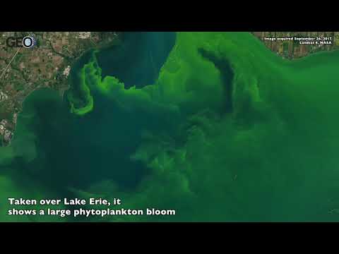
Close up, this satellite image almost looks like a painting. Taken over Lake Erie, it shows a large phytoplankton bloom. Made up of freshwater cyanobacteria (microcystis), these blooms thrive during summer. Warm water temperatures and nutrients from farm runoff make these blooms thrive.
The brightest green areas are scums, areas where cyanobacteria clumps together into floating mats. Cyanobacteria like microcystis are a harmful presence to freshwater systems as they produce a toxin that can contaminate drinking water and irritate both humans and animals.

The bloom in Lake Erie has been occurring since mid-July and was first detected in Maumee Bay, just east of Toledo. Now the highest densities have been detected along the coast of Ontario and in Maumee and Sandusky bays. NOAA’s Jaclyn Ludema explains, “Blooms form at the mouth of the Maumee River and commonly drift into the central basin. The outflow of the Detroit River pushes cyanobacteria concentrations away from the northwest corner of Lake Erie.”
This satellite image captured by the Moderate Resolution Imaging Spectroradiometer (MODIS) on NASA’s Terra satellite shows the entire area of Lake Erie and highlights were the bloom is currently concentrating:

Watch the video for a close up view of the phytoplankton bloom in Lake Erie:
More:
See Also
- Mapping Algal Blooms in Lake Erie
- Geography Mnemonics to Help Learn About the Great Lakes
- Framework for Protecting Marine Life and Humans from Harmful Algal Blooms (HAB) in the Gulf of Mexico