
Cloud streets are cumulus clouds that form in long bands along cylinders of rotating air and are roughly parallel to the ground.
How Do Cloud Streets Form?
Known also as horizontal convective rolls or horizontal roll vortices, these clouds occur when when cold air blows over warmer waters with an overlying blanket of warm air.
Rising heat and evaporated water from the body of water hits the colder air, forming columns of heated air called thermals. As this air rising into the atmosphere, it hits the blanket of warmer air which functions as a barrier and the air loops back over itself creating parallel cylinders of rotating air.
The cloud streets form when the moisture laden air cools and creates condensation in the form of these cumulous clouds.
In order for cloud streets to form, the sea surface temperature must be at least 21°C degrees (39 degrees Fahrenheit) warmer than the air.
Cloud streets form flat-bottomed cumulous clouds in lines that are parallel to the direction of the prevailing winds. The tops of cloud streets are puffy.
Where do Cloud Streets Form?
Cloud streets typically form over flat surfaces like the ocean and large lakes.

This Terra satellite image from NASA shows clouds streets that formed off the East Coast of the United States over the Atlantic Ocean.
Cloud streets can also form over land if the land surface is uniform.
von Karmen Vortex Streets
Physical obstacles like islands can disrupt the formation of cloud streets. The presence of an island in the middle of the open ocean can alter the wind flow and create air movement that spirals.
The formation of clouds that form in the presence of this spiraling wind movement are called von Karman vortex streets. The clouds are named after Theodore von Kármán who was the first to describe this cloud pattern.
This satellite image from NASA’s Aqua satellite shows the formation of von Karman vortices off the the island of Jan Mayen near Greenland. Cloud streets in the area form when cold northerly winds move over the warmer and moist ocean air of the Greenland Sea between Greenland and Svalbard and Jan Mayen.
Downwind of Jan Mayen Island, the swirling air forms von Karmen vortices. A section of the coast of Greenland can be see in the upper left corner of the satellite image.

How Big are Cloud Streets?
Cloud streets can cover hundreds of kilometers, depending on the uniformity of the surface below. The Moderate Resolution Imaging Spectroradiometer (MODIS) on NASA’s Terra satellite captured cloud streets over the Great Lakes on February 11, 2016.

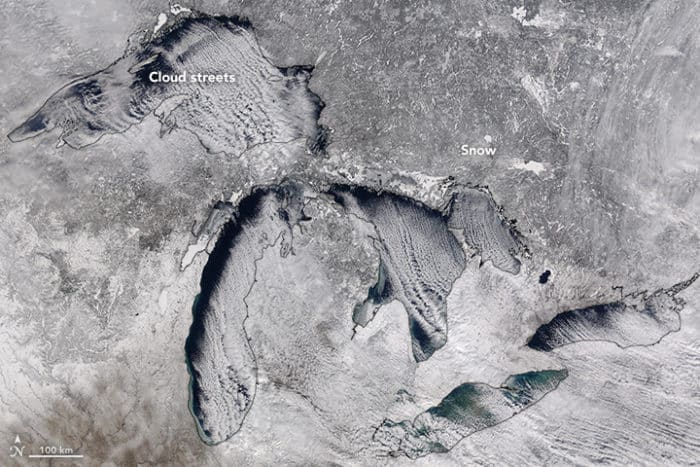
Cloud Streets Over the Great Lakes
Cloud streets tend to form over the Great Lakes during early winter as the fresh water is still cooling from the summer and winter ice is beginning to form.
This satellite image from NASA’s Terra satellite shows cloud streets that formed over the Great Lakes on January 10, 2022.
In order to distinguish between clouds and snow/ice, the image is a combination of natural color, shortwave infrared, and near infrared. Clouds are white and snow and ice show up as cyan in the satellite image.
Cloud streets can be seen streaking over Lake Superior and Lake Michigan as well as parts of Lake Huron.

Cloud Streets Over Hudson Bay
Cloud streets formed over Hudson Bay in the presence of northwesterly winds on November 13, 2012.

Video: What are Cloud Streets?
Watch the video about cloud streets:

More:
- What are cloud streets? EarthSky, January 18, 2016
- Cloud Streets: Meteorological Physical Background, KNMI, Undated
References
Carlowicz, M., & Voiland, A. (2022, January 17). Great Lakes cloud streets. NASA Earth Observatory. https://earthobservatory.nasa.gov/images/149339/great-lakes-cloud-streets
Lindsey, R. (2009, February 26). Clouds streets and von karman vortices, Greenland sea. NASA Earth Observatory. https://earthobservatory.nasa.gov/images/37222/clouds-streets-and-von-karman-vortices-greenland-sea
This article was originally published on February 17, 2016 and has since been updated.