
One function mainstream GIS applications are unable to do is create non-contiguous cartograms (related: a workaround on how to create a non-contiguous cartogram in QGIS). A cartogram is map where the geographic features are located and sized based on the intensity of variable. As a results, the features of a cartogram are not true to their geographic size or shape but there is an attempt to maintain a loose relationship to geographic space.
Contiguous cartograms, while distorting the geographic shape and size of individual polygon features, maintain spatial connectedness to neighboring polygons. Non-contiguous cartograms show each polygon feature separated from neighboring polygons. The size of each polygon feature then either enlarges or shrinks based on a specified numeric value.
Non-contiguous cartograms are a type of area cartogram. In a non-contiguous cartogram, the features are not connected and enlarge or shrink based on a quantified value.
Creating Non-contiguous Cartograms
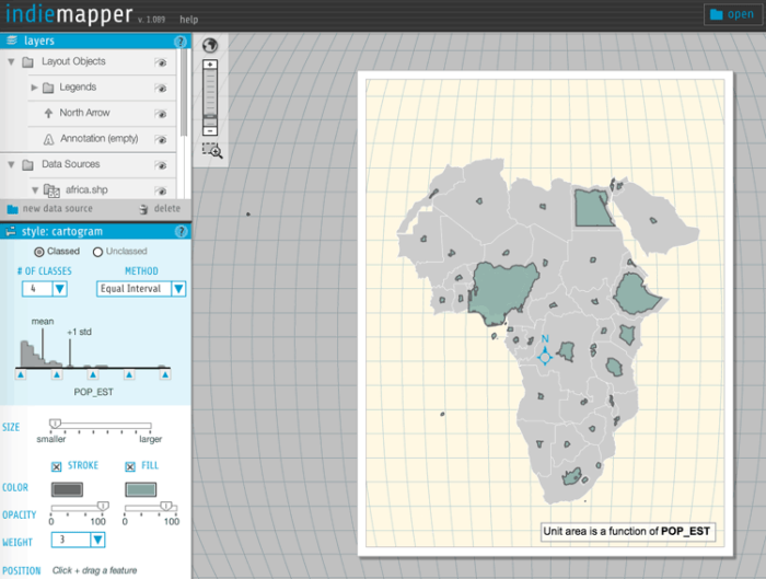
None of the mainstream GIS applications offer the ability to create non-contiguous cartograms. The free online mapping application, Indiemapper, probably offers the easiest way to create a non-contiguous cartogram. Developed by Axis Maps, Indiemapper lets you upload a shapefile, KML, or GPX file. You can then create a variety of maps including a non-contiguous cartogram.
To create a non-contiguous cartogram, first upload a polygon file to the site in one of the three format listed above. Alternatively, you can pick a dataset from one of the libraries offer in Indiemapper. Once the data is loaded, you can then select the attribute field and then cartogram as the type of visualization. There are some parameters that can be adjusted to control how the shapes are weighted in size. The cartogram can either be classed or unclassed and there is a slider to adjust the range of values considered. Indiemapper also allows you to drag and reposition individual polygons on the map which is handy for moving overlapping polygons. Set all the color, annotation, and map elements. Export options are limited to image-based only with .svg, .jpg, and .png as the choices.
Visit: Indiemapper

Creating Non-contiguous Cartograms with R
If you work with R there is a package for creating cartograms. Developed by Sebastian Jeworutzki, included with the package is code for creating non-contiguous cartograms.
Creating Non-contiguous Cartograms with D3
Developed by Mike Bockstock, this script lets you create a non-contiguous cartogram within D3.
References
Olson, J. M. (1976). Noncontiguous area cartograms. The Professional Geographer, 28(4), 371-380.