
The MIT Senseable City Lab has turned its sights to a new kind of mapping. The project, dubbed Treepedia, mapped the amount of trees that were growing in major urban areas.
The cities mapped by Treepedia included Boston, Geneva, London, Los Angeles, Paris, New York, Seattle, Tel-Aviv, Toronto, Turin, and Vancouver.
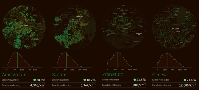
Calculating Green View Index for urban tree canopies
Treepedia used images from Google Street View to measure the urban canopies of the chosen cities. The ‘Green View Index’ was created as a measurement, to describe the tree canopy in an urban area as it would be seen from the viewpoint of the people walking below the trees.
The Green View Index measures the percentage of tree canopy coverage in any given area on a scale of zero-100 using the Google Images.
Vancouver was the most forested of all the urban areas. Vancouver had a Green View Index of 25.9%, while Paris only had 8.8% tree coverage.

The MIT Senseable City Lab created the Treepedia project to track the health of urban trees in the midst of drastic climate change. Tracking the amount of green coverage can help scientists and researchers understand how an urban environment is impacting tree growth, and how climate change is happening differently in urban versus rural areas.
The Lab also hopes to promote green canopy cover in urban areas.
Treepedia allows users to see the individual data points that were used to make up the map, as well as view things from a city-wide level. In the future, users can add information about urban trees and petition their local governments for increased green canopies in their cities.

The World Economic Forum’s Global Agenda Council on the Future of Cities also helped with the Treepedia project as part of their ongoing goal to increase the urban canopy in major urban areas worldwide. They hope the project will help create small infrastructure projects that will ultimately benefit the environment and residents of urban areas in meaningful ways.
Visit: Treepedia – MIT Senseable City Lab