
What is geocoding?
Geocoding is a way of georeferencing data by using a GIS data layer that has locational information. For example, a geographic dataset showing street information which includes the street name and the beginning and ending address tied to each street segment could be used to geocode a database with addresses.
The geocoding process creates a derivative GIS dataset in which geographic coordinates are applied to each record in the original database based on locational information applied from a secondary dataset such as a streets layer or a parcels database.
What can be geocoded?
What can be geocoded? A variety of address formats can be geocoded, depending on the type of GIS data you are using. Most commonly use is to geocode a database of addresses (street number and name). Points of interests (such as landmarks or common places), cities, and ZIP codes are other address-like records that can be geocoded.
What is reverse geocoding?
Reverese geocoding is the process of converting geographic coordinates to the nearest address.
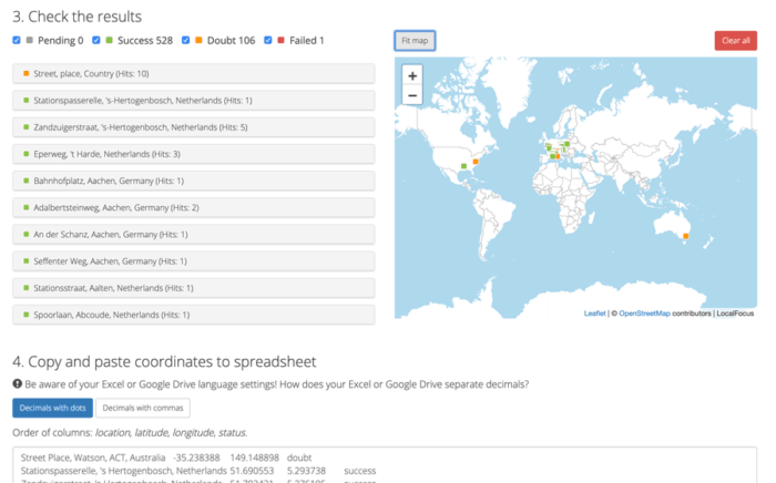
Online Geocoding
Developed by LocalFocus, this online geocoding service will generate latitude and longitude coordinates from a list of addresses for free. Listed as a “Batch geocoder for journalists” this bulk geocoding service can be used by anyone needing to convert a list of locations to latitude and longitude coordinates.
The online geocoder is built using open GIS data from OpenStreetMap, OpenAdressess, and Who’s on first. Pelias, an open-source geocoder, is used to generate the lat/long coordinates from addresses.
To use the geocoder, simply copy and paste a list of locations in the designated box. If the locations for a specific country, select it from the list, otherwise leave it at the “worldwide” default. Click on the “Add to geocoder” button to start the process.
A running status will show how many of the results have been geocoded, and a color-coded status will indicate the confidence for each geocoded location. Finally a box contains the geocoded locations along withlatitude, longitude, and status. which you can then copy and paste into a spreadsheet.
Visit: Batch geocoder for journalists – LocalFocus

Other geocoding resources
How to Geocode Addresses Using QGIS
If you have a CSV formatted file containing addresses, you can take advantage of QGIS to map out those addresses. This article contains step by step instructions for geocoding addresses using QGIS.
Geocoding 101
A basic overview of what geocoding is with a step-by-step example using ArcView 3.x. Find out how to map out your address databases whether you have a single address or a spreadsheet of postal addresses or ZIP codes.
Batch Geocode
Free service put together by Phillip Holmstrand using Google’s geocoding API. It lets you batch geocode addresses not just one at a time. Up to 3,000 records per day per IP address. The process returns a Google map of all geocoded locations and the results can be downloaded as a KML file.
Google’s Geocoding API
Google offers an API for converting addresses to geographic coordinates and for reverse geocoding. The API has a query limit of 2,500 geolocation requests per day.
GeoLocator Tool
GeoLocator is a tool designed for easy geocoding and geotagging for Wikipedia articles. Users can enter an address or drop the icon to the area of interest and the page will return Wiki geotags.