
Thousands of landslides occur every year around the world, and yet many of them that are highly fatal never make the news. More often than not, we hear about landslides that occur in Southeast Asia, China, and India. These landslides often have a high body count due to the population density in these areas. However, parts of Africa and South America also routinely are hit by devastating landslides, without much local or international awareness of the disasters occurring.
From NASA:
Of 5,741 landslides included in the Global Landslide Catalog between 2007 and 2013, roughly half occurred in Asia. Sixty-seven percent of reported deaths occurred in that region. In comparison, 7 percent of deaths were in Africa, and 18 percent were in South America. However, Kirschbaum and Stanley point out that the catalog does not include all landslides that happen. Since it is based on reports from governments and aid groups, and from news articles published in English, many small landslides—and even some large, deadly ones—are left out.
NASA satellites and imagery can detect where in the world landslides are likely to occur based on geographical features and the amount of precipitation that has fallen in the area. With this data, NASA has created a global landslide susceptibility map. By matching landslide locations with reports from each country, data can be gathered about the number of fatalities that occur from landslides around the world.
Although many landslides are reported in North America, they result in few deaths. Unfortunately, the opposite is true in South America and Africa; for a few reported landslides, there are many fatalities. NASA scientists are hoping to increase awareness of the danger of landslides in Africa and South America in order to save lives and reduce the risk of landslides hitting villages.

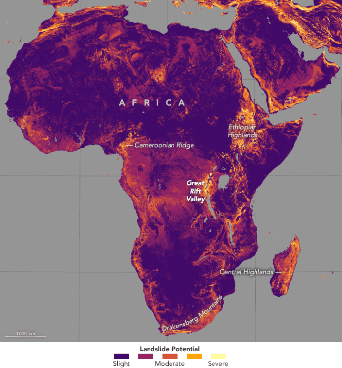
Regions like the Ethiopian Highlands, the Great Rift Valley, and the Albertine Rift in Africa are all at great risk for landslides. Deforestation, mountains, and a regular wet season destabilize the hills and make them highly vulnerable to sliding. If a landslide occurs in these regions, few people hear about it. Many of the people affected are from small villages, cut off from the world by geography and a lack of technology.
Researchers are hoping that there will be improvements in risk reduction strategies and awareness of landslide potential in locations like Africa and South America. Not only do locals have to understand the risks of the geography around them, but researchers internationally can create models and methods for stabilizing the land in the region and keeping more people safe from landslides.
More: Overlooked Landslides, NASA.