
Terrapattern is a way to search visually within satellite imagery. Developed using an open source search tool, Terrapattern is the brainchild of Golan Levin, David Newbury, and Kyle McDonald who received funding from the John S. and James L. Knight Foundation Prototype Fund.
What Terrapattern does is perform “similar-image” searches in unlabeled satellite imagery using deep learning machine vision techniques. To train the system, a deep convolutional neural network (DCNN) was fed hundreds of thousands of categorized OpenStreepMap imagery. After the DCNN has learned which visual features are useful for classification, descriptions for millions of satellite imagery tiles were then computed. Since searching can take a long time and a significant amount of RAM, the developers use the CoverTree algorithm to precompute relationships between the descriptions, reducing user search time to 1-2 seconds.
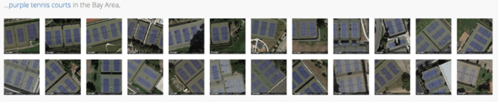
This approach allows users to search for particular features across a set of satellite imagery with nonbuilding structures (structures such a bridges, bus shelters, and swimming pools) and soft infrastructure yielding the best search results. For example, users can search for images that show yellow crosswalks, purple tennis courts, grassy fields, and more. Terrapattern lets users search visually for geographic features that may be ephemeral or not typically mapped out. Results from searches are then exportable as GeoJSON files.

Terrapattern is currently only available for these four major U.S. cities: New York, Detroit, Pittsburgh, and San Francisco. An alpha prototype, the developers are limited by the enormous about of active RAM (about 10GB per major city) that terrapattern takes to store the model data. The developers are interested in hearing back from “citizen scientists, data journalists, humanitarian researchers, and other domain experts to tell us about how our app is, or could be, of use.” Fill out the survey to provide your input.
Visit: Terrapattern and access the code on GitHub.
Related
- Using Visual Search to Find Geographically Similar Features on Satellite Imagery