
The color symbology in displaying a GIS data on a map is an important decision to make in communicating geographic data. But, this is one area we often neglect or we simply choose what we might consider pretty or having a lot of color variety. In fact, research shows that selecting color symbology covering a wide range of colors is often a poor choice, where better ways of color selection might be needed in light of limitations of our visual perceptions.
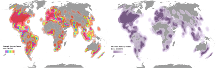
Choosing selections with a diverse range of colors may not be the wisest of choices. Take rainbow color symbologies, which display colors ranging from blue to red with seven distinct colors and different shades. Several problems exist with this type of symbology, which includes difficulty in identification for visually impaired people, small details often obscured by the color blending and near colors, phantom features could begin to appear when colors are in close proximity to each other, high and low data values are often minimized or affected by color variation, and perhaps most clearly there is no natural perception of the colors in the rainbow within our brains. This could have important limitations in scientific applications due to our limited perceptions such as in identifying or using colors in diagnosing coronary heart disease.[1]

While these problems highlight selecting color displays or symbologies that are diverse such as rainbow displays, the question arises as to what makes the best selection for displaying our maps or spatial data? The answer is not always clear but it depends on what one is trying to show. Take, for instance, data we want some sort of classification. Here, shaded colors or a graduated symbology with fewer colors but more shades could be effective.[2] One argument is five shades of color variation is often enough for a variety of outputs, where it becomes difficult for us to distinguish more than five meaningful shades of given colors. If other colors are required, then it could be best to vary the hue of give colors.[3]Tools now exist, such as ColorBrewer 2.0, where cartographic choices can be made so that users can select the right number of colors to display and the best combination that incorporates colors, shades, and hues.[4]

Symbology is also critical to display multiple dimension data, where color could be important but might not be the only element. Take, for instance, displaying two-dimensional data, where a symbol’s size, such as a point, as well as its color could be useful to display. Population and measures such as GDP/capita might be one example of how multiple dimensions are shown via one type of symbol, that is a point’s size, and another, which could be a color ramp with a graduated color scheme.[5]
Coming back to the rainbow color scheme, there have been methods proposed that allow a better selection of varied color combinations used for display. A diverging color map could utilize combinations of ratios, bipolar, or double-ended color variation that allows extreme values to be identified and maximized on information displayed that also addresses visual properties that limit our perceptions. In other words, selecting combinations that address our visual limitations while maximizing variety we can perceive allows an algorithmic determination of color selection to be possible.[6]
Choosing an appropriate map color and display combination is not an easy choice. This is particularly the case when we have a wide and diverse range of information. Methods have been created to attempt to apply scientific approaches to better display a combination of colors based on visual properties and selection of data for a given domain. These methods range from simply testing user perceptions and seeing what provides the easiest information display to more algorithmic methods that maximize on our ability to differentiate color information while minimizing in properties that may confuse us.
References
[1] For more on visual problems for color symbologies, particularly rainbow colors, see: https://blogs.mathworks.com/steve/2014/10/20/a-new-colormap-for-matlab-part-2-troubles-with-rainbows/. Or for another scholarly perspective, see: Borkin, M., K. Gajos, A. Peters, D. Mitsouras, S. Melchionna, F. Rybicki, C. Feldman, and H. Pfister. 2011. “Evaluation of Artery Visualizations for Heart Disease Diagnosis.” IEEE Transactions on Visualization and Computer Graphics17 (12): 2479–88. https://doi.org/10.1109/TVCG.2011.192.
[2] For more on graduated symbology and its use in quantitative data, see: Kelleher, Christa, and Thorsten Wagener. 2011. “Ten Guidelines for Effective Data Visualization in Scientific Publications.” Environmental Modelling & Software26 (6): 822–27. https://doi.org/10.1016/j.envsoft.2010.12.006.
[3] For more on varying hue and color shades, see: Peterson, Gretchen N. 2014. GIS Cartography: A Guide to Effective Map Design. Second edition. Boca Raton: CRC Press, pg. 98.
[4] For more on ColorBrewer 2.0, see: http://colorbrewer2.org.
[5] For more on combinations of symbology and colors, see: Peterson, 2014.
[6] For more on using diverging color maps for visualizing data, see: Moreland, Kenneth. 2009. “Diverging Color Maps for Scientific Visualization.” In Advances in Visual Computing, edited by George Bebis, Richard Boyle, Bahram Parvin, Darko Koracin, Yoshinori Kuno, Junxian Wang, Renato Pajarola, et al., 5876:92–103. Berlin, Heidelberg: Springer Berlin Heidelberg. https://doi.org/10.1007/978-3-642-10520-3_9.