
A disruption of the polar vortex has allowed extremely cold air to descend to over parts of North America as far south as Texas.
What is the Polar Vortex?
The polar vortex is a large area of low pressure and very cold air over the North and South Poles. During the winter in the Northern Hemisphere, the polar vortex can become unstable and expand southward.
When this happens, colder than normal air from the Arctic descends over parts of Canada and the United States.

Polar Vortex Moving Over the United States
Crushing cold due to the polar vortex moving over the United States has happened before. In 2019, NASA satellites captured data showing the polar vortex as it moved south between January 20 through January 29.

NASA’s Atmospheric Infrared Sounder (AIRS) instrument aboard the Aqua satellite captured air temperatures at 10,000 – 15,000 feet in this animation. The coldest temperatures are colored purple and blue and range from -40 degrees Fahrenheit (also -40 degrees Celsius) to -10 degrees Fahrenheit (-23 degrees Celsius).
The animation shows the coldest temperature air (purple and blue) moving southward from central Canada into the U.S. Midwest.
February 2021 Polar Vortex
The latest disruption of the polar vortex has hit the United States pretty severely in mid-February. Texas is experiencing an unprecedented freeze that has knocked out power to millions of its residents as temperatures remain well below zero.
The Midwest and the Plains are also experiencing record-breaking lows with areas reporting temperatures well below freezing.
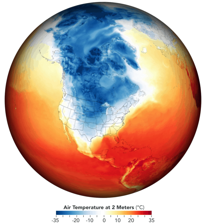
Map of February Temperatures Across North America
Using data from the Goddard Earth Observing System (GEOS) model, NASA researchers mapped out temperatures across the United States and Canada on February 15, 2021.

The map shows air temperature a two meters on February 15, 2021. Shades of blue show cold weather across central and southern United States while areas in mid and southern Florida reached temperatures of about 35 degrees Celsius.
The darkest blue areas of the map indicate that temperature dropped as low as -35°C (-31°F). Parts of Texas were colder than Alaska and Maine. Dallas, Texas typically sees temperatures in the 60s (F) but recorded a low of 4°F (-16°C) on February 15. This is the coldest the city has been since 1989.
More:
Hansen, K. (2021, February 16). Extreme winter weather causes U.S. blackouts. NASA Earth Observatory. https://earthobservatory.nasa.gov/images/147941/extreme-winter-weather-causes-us-blackouts