
Okjökull was once a large glacier in Iceland located in western Iceland on top of the volcanic mountain Ok. A geologic map dating back to 1901 show its size as being 38 square kilometers (15 square miles).
Since then, the glacier has been decreasing in size. In 2014, the glacier was declared officially dead and on August 18, 2019, a ceremony will unveil a monument to acknowledge the glacier’s decline.
Okjökull is believed to be the first glacier to disappear due to human-induced climate change.
Researchers from Rice University in Houston, author Andri Snær Magnason and geologist Oddur Sigurðsson, are behind the creation of this monument. The glacier was the subject of Not Ok, a documentary about the glacier’s disappearance.
From the press release:
“This will be the first monument to a glacier lost to climate change anywhere in the world,” Howe said. “By marking Ok’s passing, we hope to draw attention to what is being lost as Earth’s glaciers expire. These bodies of ice are the largest freshwater reserves on the planet and frozen within them are histories of the atmosphere. They are also often important cultural forms that are full of significance.”

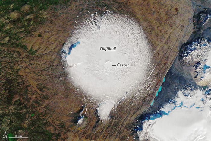
Two images released by NASA highlight just how much the glacier has declined in the past decades. The first image, taken by Thematic Mapper (TM) on Landsat 5 on September 7, 1986 shows the glacier’s extent.
By 1978, Okjökull had already been reduced to an area of less than 3 kilometers.

By August 1, 2019, less than one square kilometer remains of the glacier.
Only small patches of ice remain in this image captured by Landsat 8’s Operational Land Imager.

More:
- Okjökull Remembered, NASA