
In the 1860s, a young girl decided to amuse her sick brother by creating maps of various European countries. Inspired by the caricatures from the puppet show, Punch and Judy, she drew anthropomorphic maps of several countries in Europe. These colorful 12 maps ended up being published in 1868 in a book entitled, “Geographical Fun: Being Humourous Outlines of Various Countries.” Each map is colorfully illustrated and contains a stereotyped drawing that adheres to the shape and boundaries of each country. Surrounding the caricature, labels have been placed along the coastlines highlighting cites found within the folds of the drawing as well as labels for water features, fjords, islands, and other geographic features.
The intent of publishing these caricature maps was to serve as an educational aid for school students learning geography. The introduction notes:
“It is believed that these illustrations of Geography may be rendered educational and prove of service to young scholars, who commonly think Globes and Maps but wearisome aids to knowledge, by enabling them to retain the outline of various countries so humorously caricatured in the work, by associating them in their mind’s eye with odd fancy figures.”
While the book was anonymously published both the identity of the cartographer and the author of the prefaces and the quatrains (a poem with four lines) were later uncovered by researchers. The maps were created by Lilian Lancaster [1852-1939] who later went on to become a Victorian actress and comedienne. As part of one of her popular acts, she was a “lightning cartoonist”, drawing rapid pictures of audience members and caricature maps. The introduction and poems accompanying each map were written by William Harvey [1796-1873] who published under the pseudonym “Aleph”.
While a book of caricature maps may not seem educational to most, Harvey notes in his introduction that “nearly every system of artificial memory supposes arbitrary way-marks, with which dates and events are to be connected, and we have all remarked, when we are at a loss to recollect words or things, how vividly they are recalled when the mind is able to grasp objects associates with them…. If these geographical puzzles excite the mirth of children; the amusement of a moment may lead to the profitable curiosity of youthful students, and imbue the mind with a healthful taste for an acquaintance with foreign lands.” Harvey concludes with, “No history, no journal can be understood without a knowledge of maps, and good service is done when we make such information more easy and agreeable.”
Watch:Victorian Cariacature Maps
Images of each individual map are after this video.

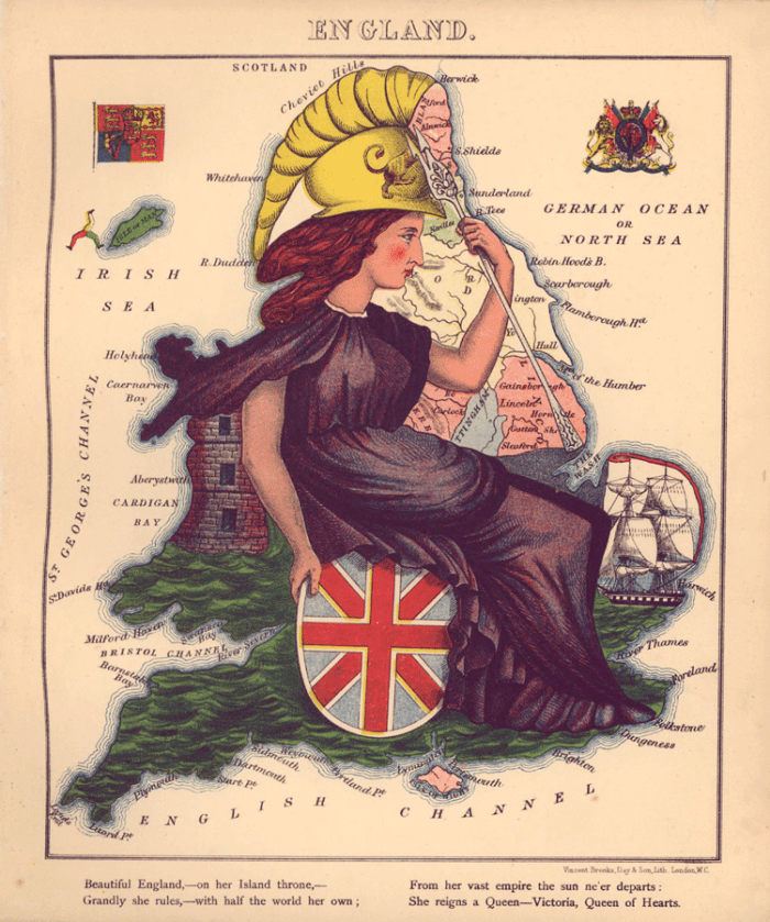
Map of England as Queen Victoria Dressed as Britannia Ruling the Waves
Beautiful England, – on her Island Throne, –
Grandly she rules, – with half the world her on;
From her vast empire the sun ne’er departs;
She reigns a Queen – Victoria, Queen of Hearts.

Map of Scotland as the Struggling Piper
A gallant piper, struggling through the bogs,
His wind bag broken, wearing his clay clogs;
Yet, strong of heart, a fitting emblem makes
For Scotland – land of heroes and of cakes.

Map of Wales as Owen Glendowr
Geography bewitch’d – Owen Glendowr,
In Bardic grandeur, looks from shore to shore,
And sings King Arthur’s long, long pedigree,
And cheese and leeks, and knights of high degree.

Map of Ireland as a Peasant
And what shall typify the Emerald Isle?
A Peasant, happy in her baby’s smile?
No fortune her’s, – though rich in native grace, –
Herrings, potatoes, and a joyous face.

Map of France as a Lady
A hook-nosed lady represents fair France,
Empress of cooked, of fashions, and the dance.
Her flatt’ring glass declares that vict’ry, power,
Beauty, wealth, arts, are her imperial dower.

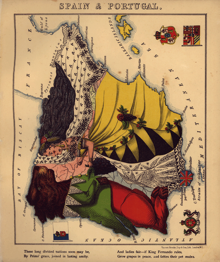
Map of Spain and Portugal as Ladies
These long divide nations soon may be,
By Prims’ grace, joined in lasting amity.
And ladies fair – if King Fernando rules,
Grow grass in peace, and fatten their pet mules.
Map of Italy as Guiseppe Garibaldi
Thou model chieftain – born in modern days –
Well may thy gallant acts claim classic praise.
Uncompromising friend of liberty!
Thy Photography ennobles Italy!

Map of Kaiser, Wilhelm I presenting notes to his Iron Chancellor, Otto von Bismarck
His Majesty of Prussia – grim and old –
Sadowa’s King – by needle guns made bold;
With Bismark of the royal conscience keeper,
In dreams political none wiser – deeper.

Map of Germany as a Lady
Lo! studious Germany, in her delight,
At coming glories, sheen by second sight,
And on her visioned future proudly glancing,
Here joy expresses by a lady dancing.

Map of Holland [The Netherlands] and Belgium as a Lady Holding a Smoking Toddler Boy
Dame Holland, trick’d out in her gala clothes,
And Master Belgium, with a punchy nose;
Seem on the map to represent a land,
By patriot worth, and perfect art made grand.

Map of Denmark
For Shakespeare’s Prince, and the Princess of Wales,
To England dear. Her royal spirit quails;
From skating faint, she rests upon the snow;
Shrinking from unclean beasts that grinw below.

Map of Russia with a Great Bear Standing Back to Back With Tsar Alexander II
Peter, and Catherine, and Alexander,
Mad Paul, and Nicholas, poor shadows wander
Out in the cold; while Emperor A. The Second
In Eagles, Priests, and Bears supreme is reckoned.

References
Harvey, W. (1868) Geographical Fun: Being Humourous Outlines of Various Countries, With an Introduction and Descriptive Lines. [London: Hodder and Stoughton, ?] [Map] Retrieved from the Library of Congress, https://www.loc.gov/item/84675540/.
Barron, R. M. (2008). Bringing the map to life: European satirical maps 1845-1945. Belgeo. Revue belge de géographie, (3-4), 445-464. http://journals.openedition.org/belgeo/11935#tocto1n10