
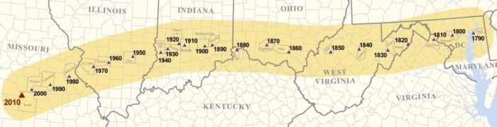
The U.S. Census Bureau has announced the mean center of the United States based on the 2010 Census. The official mean population center for the United States as of April 1, 2010 is a location near the town of Plato in Missouri. (Related: Population Center of the United States, 1790 – 2020)
The Census Bureau defines the mean center of population as “the place where an imaginary, flat, weightless and rigid map of the United States would balance perfectly if all 308,745,538 residents counted in the 2010 Census were of identical weight.”
The mean center of population has been calculated every ten years starting in 1790 where it was located in Chesterton, Maryland. Since then, the center has moved westward and slightly south as the western states have become more populated.
To mark this new mean center of population, a commemorative geodetic control mark will be installed at the location during a ceremony in April, 2011.
Maps, white papers, and data relating to the mean center of population can be accessed here.

About the 2010 Mean Center of Population:
37.517534 N, 92.173096 W – Coordinates (latitude, longitude) in decimal degrees of the 2010 mean center of population and the most western and southern point in our nation’s history, as well as the most southerly movement from the previous decade.
2.7 – Distance in miles from the center of population coordinates to Plato, Mo., the nearest incorporated municipality and nearest place for which the Census Bureau provides data.
109 – The 2010 Census population of Plato, Mo.
26,008 – The 2010 Census population of Texas County, Mo., where the village of Plato is located
Table: Centers of Population 1790 – 2000
Listed here is a table of the center of population as calculated by the US Census from 1790 to 2000.
| Year | Latitude | Longitude | County, State | Location |
| 2000 | 37.6969870 | -91.8095670 | Phelps County, MO | approximately 2.8 miles east of Edgar Springs |
| 1990 | 37.8722200 | -91.2152800 | Crawford County, MO, | 10 miles southeast of Steelville. |
| 1980 | 38.1369400 | -90.5738900 | Jefferson County, MO, | 1/4 mile west of DeSoto. |
| 1970 | 38.4630600 | -89.7061100 | St. Clair County, IL, | 5 miles east-southeast of Mascoutah. |
| 1960 | 38.5994400 | -89.2097200 | Clinton County, IL, | 6-1/2 miles northwest of Centralia. |
| 1950 | 38.8041700 | -88.3688900 | Clay County, IL, | 3 miles northeast of Louisville. |
| 1950 | 38.8391700 | -88.1591700 | Richland County, IL, | 8 miles north-northwest of Olney. |
| 1940 | 38.9483300 | -87.3763900 | Sullivan County, IN, | 2 miles southeast by east of Carlisle. |
| 1930 | 39.0625000 | -87.1350000 | Greene County, IN, | 3 miles northeast of Linton. |
| 1920 | 39.1725000 | -86.7208300 | Owen County, IN, | 8 miles south-southeast of Spencer. |
| 1910 | 39.1700000 | -86.5388900 | Monroe County, IN, | in the city of Bloomington. |
| 1900 | 39.1600000 | -85.8150000 | Bartholomew,IN | 6 miles southeast of Columbus. |
| 1890 | 39.1988900 | -85.5480600 | Decatur County, IN | 20 miles east of Columbus. |
| 1880 | 39.0688900 | -84.6611100 | Boone County, KY, | 8 miles west by south of Cincinnati, OH. |
| 1870 | 39.2000000 | -83.5950000 | Highland County, OH, | 48 miles east by north of Cincinnati. |
| 1860 | 39.0066700 | -82.8133300 | Pike County, OH, | 20 miles south by east of Chillcothe. |
| 1850 | 38.9833300 | -81.3166700 | Wirt County, WV, | 23 miles southeast of Parkersburg (2). |
| 1840 | 39.0333300 | -80.3000000 | Upshur County, WV, | 16 miles south of Clarksburg. Upshur County was formed from parts of Barbour, Lewis, and Randolph Counties in 1851(2). |
| 1830 | 38.9650000 | -79.2816700 | Grant County, WV, | 19 miles west-southwest of Morefiled. Grant County was formed from part of Hardy County in 1866 (2). |
| 1820 | 39.0950000 | -78.5500000 | Hardy County, WV, | 16 miles east of Moorefield (2). |
| 1810 | 39.1916700 | -77.6200000 | Loudoun County, VA, | 40 miles northwest by west of Washington, DC. |
| 1800 | 39.2683300 | -76.9416700 | Howard County, MD, | 18 miles west of Baltimore. Howard County was formed from part of Anne Arundel County in 1851. |
| 1790 | 39.2750000 | -76.1866700 | Kent County, MD, | 23 miles east of Baltimore. |