

The Vinland Map is supposed to be a 15th century map that depicts North America, specifically the Newfoundland coast, that was revealed to the world in 1965. The map was purported to be associated with an obscure volume called The Tartar Relation that dated from the time of the map. Vinland is the region that purports to show North America (labeled as Vinlanda Insula). As soon as it was released by Yale University, controversy has surrounded the map, where it is claimed to be a forgery.[1]

Earlier studies of the map had indicated pigments used in the ink derived from the 20th century, sometime around 1920, rather than the 15th century. After the map’s release, a major conference inviting scholars to look at the map commenced. These scholars published the proceedings, where the general conclusion was the map was a fake, although Yale continued to take a neutral stance stating further work is needed and they would continue to hold onto the map for the time to come. Further conferences continued and periodically the map would be investigated by various scholars and amateur historians.[2]
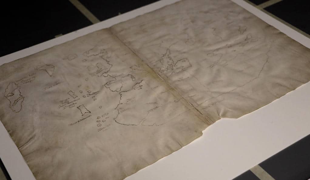
Given the continued controversy, new methods have now been developed to once again re-investigate the map. Yale’s Institute for the Preservation of Cultural Heritage (IPCH) is using a geodesic-dome cage where an array of cameras and lamps will be fixed to take pictures of the map’s surface from different angles. This will allow also a detailed perspective of the texture so that even the ink can be studied for its thickness and variation across the map. The analyses will also include reflectance transformation imaging (RTI), which is a technique that measures the color and shape of surface objects through lighting techniques from different angles. This helps to reveal hidden surface features such as marks or other information. Additional analysis will include x-ray fluorescence spectroscopy (XRF) that can be used to show the spatial distribution of elements across different parts of the map or within areas of the map’s surface. The distribution of elements can help to demonstrate what type of instrument, and if it existed in the 15th century, created the map. The results of the analyses will be published in a book and accompany a forthcoming exhibition on the Vikings, who were the supposed creators of the original map used to create the Vinland Map.[3]

What has though led some scholars to consider the possibility of the authenticity of the map is the fact that shortly after the release of the map, archaeologists did find evidence of Viking-era settlements in North America, which were several hundred years before Columbus. Earlier scholars in the 1950s, before the map was made available to the outside world, had concluded the map was authentic based on known cartographic techniques available from the Medieval period. No known Viking maps exist, however, and, in fact, the Old Norse language does not even have a word for map. Vikings simply navigated using their knowledge of the seas and stars rather than document their travels using maps.[4]
Other scholars have pointed out that in the 16th century, about 100 years after the map was supposedly created, early depictions of North America after Columbus often show greater error in depicting the landforms than the earlier Vinland Map. Some ask how is it possible the Vikings were able to create a map, where they had no known cartographic skills, and make something more accurate than later depictions?[5]
The new results supported by Yale may help to diminish the debate surrounding the map. Whatever the outcome, it will demonstrate new ways in which the authenticity of cartographic maps, using RTI and other techniques. For historical map analysis, this could be a new chapter.
Reference
[1] For background on the Vinland Map, see: Monmonier, M. S. (1995). Drawing the line: tales of maps and cartocontroversy (1st ed). New York: H. Holt.
[2] For more on the proceedings of the initial major study on the map, see: Washburn, W. E., & Smithsonian Institution (Eds.). (1971). Vinland Map Conference: Proceedings. Chicago: Published for the Newberry Library by the University of Chicago Press.
[3] For more on recent developments on the Vinland Map by Yale, see: https://news.yale.edu/2018/02/28/yale-putting-high-tech-tests-its-controversial-vinland-map.
[4] For more on Norse settlement in North America and mapping in the Viking Age, see: Ingstad, H., & Ingstad, A. S. (2001). The Viking discovery of America: the excavation of a Norse settlement in L’Anse aux Meadows, Newfoundland. New York: Checkmark Books.
[5] For more on 16th century map making and the Vineland Map, see: Seaver, K. A. (2004). Maps, myths, and men: the story of the Vinland map. Stanford, Calif: Stanford University Press.