
Climatology

Review | Drought, Flood, Fire: How Climate Change Contributes to Catastrophes
"Drought, Flood, Fire: How Climate Change Contributes to Catastrophes" is written by a scientist who understands how to meaningfully inform his non-scientist readers.

North American Monsoon
The North American Monsoon is a pattern of increased rainfall that occurs across much of the southwestern USA and northern Mexico, often commencing in July and ending in September.

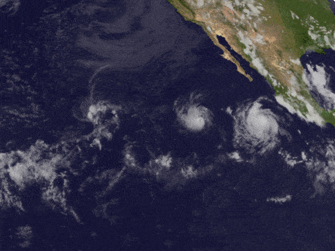
Storms of the 2021 Hurricane Season
While the official 2021 hurricane season officially lasts from June 1 to November 30, 2021, the first storm of the season has already happened.

Coldest Temperature of Clouds Recorded by a Satellite
Researchers measured the coldest temperature ever recorded by a satellite of a cloud.

Geography of Hailstorms in the United States
While hail can form anywhere in the United States experiencing a thunderstorm, geography influences where hailstorms are more likely to occur.
Fujiwhara Effect: When One Storm Absorbs Another
When two storms move towards another, an uncommon phenomenon called the Fujiwhara Effect can happen.

Half of the United States Will Continue to be Affected by Drought for Spring 2021
Drought conditions in much of the United States are forecasted to continue for spring 2021.

How San Francisco’s Geography and Microclimate Affect Baseball
San Francisco's geography shaped the microclimates that affected baseball at Candlestick Park.

2020 Hurricane Season
Each year, the World Meteorological Organization creates a list of official names for major storms in the both Northern Pacific and Atlantic oceans.

The Polar Vortex is Causing Extreme Cold in Parts of the United States
A disruption of the polar vortex has allowed extremely cold air to descend to over parts of North America as far south as Texas.


Mount Fuji’s Snow is at a 20-Year Low
Satellite data that has tracked snow cover on Mount Fuji shows that the 2020 snow levels are the lowest since 2000.

What is a Medicane?
Medicane is a tropical-like cyclone that forms in the Mediterranean Sea.

Mapping California’s Heatwave from Space
NASA's Ecosystem Spaceborne Thermal Radiometer Experiment (ECOSTRESS) has been mapping temperatures across parts of California from space.

Smoke from Australian Wildfires Reaches Atmospheric Highs
Smoke from the 2019 wildfires not only impacted Australian population centers but drifted far into the atmosphere as well.

Amphan is the Strongest Super Cyclone Ever Recorded in the Bay of Bengal
Amphan is a powerful cyclone that has formed in the Bay on Bengal.

Arthur is the First Named Storm of the 2020 Hurricane Season
Arthur is the first named storm of the 2020 hurricane season which officially begins on June 1, 2020.

Atmospheric Ozone Hole Over Arctic Region
A combination of atmospheric factors have led to the creation of the lowest levels of ozone in a decade over the Arctic.

2020 Hurricane Season is Likely to be More Active Than Usual
A newly released hurricane outlook from the Weather Channel expects the upcoming 2020 hurricane season to be more active than normal.

As the Ozone Layer Recovers it is Changing Wind Patterns
Researchers from the University of Montreal used satellite data and climate modeling to understand how the recovery of the ozone layer has affected the Earth's atmosphere.

Satellites Give Detailed Insights into Climate Sciences
The European Space Agency has recently released a report entitled ‘10 New Insights in Climate Science’.
What is a Snow Devil?
Miniature vortexes of wind can stir up snow in a formation known as a snow devil.

Driest Non-polar Desert in the World
Situated in northern Chile, the Atacama Desert is one of the driest places on Earth.

Looking at Centuries of California’s Climate to Understand Fire Risk
Researchers examined moisture patterns and atmospheric wind conditions in California using climate models and centuries of paleoclimate data (from 1571 to 2013).

Earliest Published Research Linking Carbon Dioxide with Global Warming
163 years ago, Eunice Newton Foote was the first scientist to research the link between increased carbon dioxide and a warmer atmosphere.

Deforestation Is Drying Up Atmospheric Rivers
Deforestation has a dramatic impact on climate, reducing evapotranspiration which feed atmospheric rivers.