
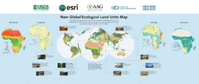
With a base resolution of 250 meters, Esri and the United States Geological Survey (USGS) have developed the highest spatial resolution ecological land units (ELUs) map of the world commissioned by the intergovernmental Group on Earth Observations (GEO). Ecological Land Units are created by classifying ecological and physiographic information about land surface features to form a composite of geology, landform, and elevation zones.
“This map provides, for the first time, a web-based, GIS-ready, global ecophysiographic data product for land managers, scientists, conservationists, planners, and the public to use for global and regional scale landscape analysis and accounting,” said Roger Sayre, Senior Scientist for Ecosystems, with the USGS. “The Global ELU map advances an objective, repeatable, ‘big data’ approach to the synthesis and classification of important earth surface data layers into distinct and ecologically meaningful land units.”
According to Randy Vaughan, Manager of Content Engineering at Esri, creating a global map of ELUs is important for conservation planning such as identifying the most diverse ecological land features, studying ecological diversity, rarity, and evolutionary isolation. The ecological land units also allow for assessing ecosystem processes like carbon storage and soil formation as well as understanding risks leading to environmental degradation. “The ecological land units also lend themselves to the study of ecological diversity, rarity and evolutionary isolation,” said Randy Vaughan from Esri. “For example we can identify the most diverse landscapes in terms of unique ecological land features. Understanding diversity can point the way to improved conservation planning.”
Vaughan explains how the GIS data was created:
The globe was divided in cells (Ecological Facets) at a base resolution of 250 meters. The Facets were then characterized (attributed) with four input layers that drive ecological processes: bioclimate, landform, lithology, and land cover parameters. The layers chosen were the best available in terms of accuracy, currency, and global coverage. The result was a global raster data layer with 47,650 unique combinations of the four input layers. The Facets were then aggregated into 3,923 ecological land units (ELUs).
More detailed about the Global ELUs map can be found on Esri’s blog. Esri has also create a Story Map about the Ecological Land Use Map. See the custom app at esriurl.com/EcoTapestry.
