
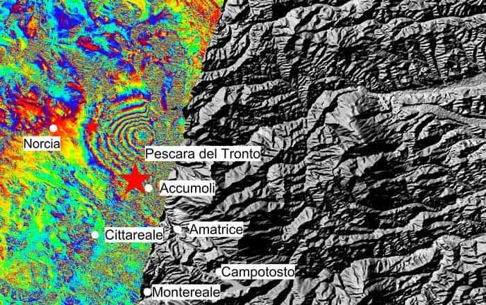
The European Space Agency posted this interferogram showing ground displacement as a result of the recent earthquake in Italy. The magnitude 6.2 earthquake struck central Italy during the early morning hours on August 24.
The epicenter was about 10 kilometers southeast of Norcia, Italy and resulted in over 200 deaths to date and massive damage to the medieval towns in the area. More than 1,000 aftershocks have continued to exacerbate problems in the region.
The European Space Agency’s Sentinel-1 captured two radar scans of central Italy, one on August 20th (Sentinel-1B) and the second on August 26th (Sentinel-1a). While Sentinel-1’s swath over the area on August 26th did not cover the entire area affected (a return pass will occur on August 27 that will capture the entire region), the ESA was able to combine the two radar scans in order to quantify ground displacement.
Known as Interferometric SAR (InSAR), the ESA explains the results of the image below:
The seven interferometric ‘fringes’ correspond to about 20 cm of surface deformation in the radar sensor line of sight. Each fringe (which is associated to a colour cycle) corresponds to approximately 2.8 cm of displacement.

To download a higher resolution image visit: Italy earthquake displacement
