
This study by Thankam Theresa Paul, Sandhya KM, Manoharan SM and Usha U takes a look at the spatial relationship between physico-chemical variables and fish production using inverse distance weighting.
Introduction
Reservoirs, an ecotone of lotic and lacustrine systems in India cover an area of about 3.15 million ha of the country. Both the characters of a lacustrine as well as lotic environment coexist in reservoirs. Tropical reservoirs are renowned for fish bio-diversities similar to other aquatic pastures since the ecotones in reservoirs provide an abode for enriched biodiversity of the populations of the plankton, benthos and fishes. It may be also noted that physico-chemical condition of water directly impacts the survival, growth, reproduction and distribution of fishes, plankton and benthos. It’s often stated that the fish production is related to physico-chemical variables especially dissolved oxygen. Representation of spatial distribution of dissolved oxygen may be used as a locator for the apparent fish available zones in reservoir.
Methodology
Two tropical reservoirs, namely Tirumoorthy and Aliyar reservoirs, encompassed in Western Ghat biosphere, constructed across the tributaries of the riverine Bharathapuzha in India have been used for this study. Statistical analysis of physico-chemical variables against fish production in these two tropical reservoirs in India resulted in creation of map to direct the stakeholders to the apparent fish available zones. Various physico-chemical variables such as dissolved oxygen, pH, alkalinity and hardness were analysed as per APHA (1998) and evaluated against the catch data at various zones in a reservoir. The possibilities of spatial interpretation of these variables on a GIS platform using inverse distance weightage (IDW) model had been adequately utilized in this study.
Results and Discussion
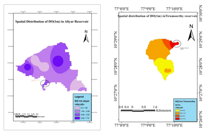
The IDW clearly showed that dissolved oxygen was more in sampling stations where the confluence effects of riverine and lacustrine water and its consequent effects of thermocline and oxycline breakdown is experienced. The model represents some stations with more DO, which may be due to increased oxygen production due to sunlight penetration in this area. Sampling at various stations and the consequent analysis resulted in the conclusion that the stations with good dissolved oxygen (>6ppm) may be identified as apparent fish available zones in reservoirs. These are the plausible zones were dissolved oxygen was high enough to support the existing fish fauna of the niche. These zones are usually the confluence zones where the lotic riverine meets the lentic lacustrine ecosystem. It had also been concluded that most of these zones are identified by fishermen as an indigenous technical knowledge for easy harvest of the fisheries resources.
This system would eventually help in time consumption and increased per unit catch effort of the local primary beneficiaries. Literature supports that the fish fauna conglomerate for breeding as well as feeding in these ecotones since these zones are conducive for the same and support the fish fauna by providing a better environment in terms of physico-chemical parameters such as good DO, less pollution and other ionic variables. The role of ionic variables in fish accumulation requires more study which is anticipated to be conducted in the near future.
The studies exemplify the possibility of using satellite images in small reservoirs along with GIS to identify potential fishing zones for the fishers, thereby to increase production from these ecosystems. In India, with the limited supply of fishes for domestic use from marine sector and the low fisheries productivity of reservoirs even after repetitive stocking of fishes, would be solved to an extent by targeted area of harvesting especially using these apparent fish available zones in reservoirs. The study also emphasizes that the fishes would be most available towards the surface on account of good DO circulation and to deeper layers at the confluence where the chance of oxycline destruction is more due to mixing of water from two sources. The Inverse distance weightage model clearly explained this in Fig 1 and 2.

The circled portion where the dissolved oxygen is high, had good fish catches and is usually identified as spots of good harvest as an indigenous technical know-how. This may be identified as a method to find the best harvestable zones in a reservoir.
Acknowledgements
I would like to thank the director, Central Inland Fisheries Research Institute (CIFRI) for his support.
Thankam Theresa Paul, scientist, CIFRI, India ; Sandhya KM, scientist, CIFRI, India; Manoharan SM, Technical Officer, CIFRI, India and Usha U, technical Officer, CIFRI, India have also contributed to this paper.