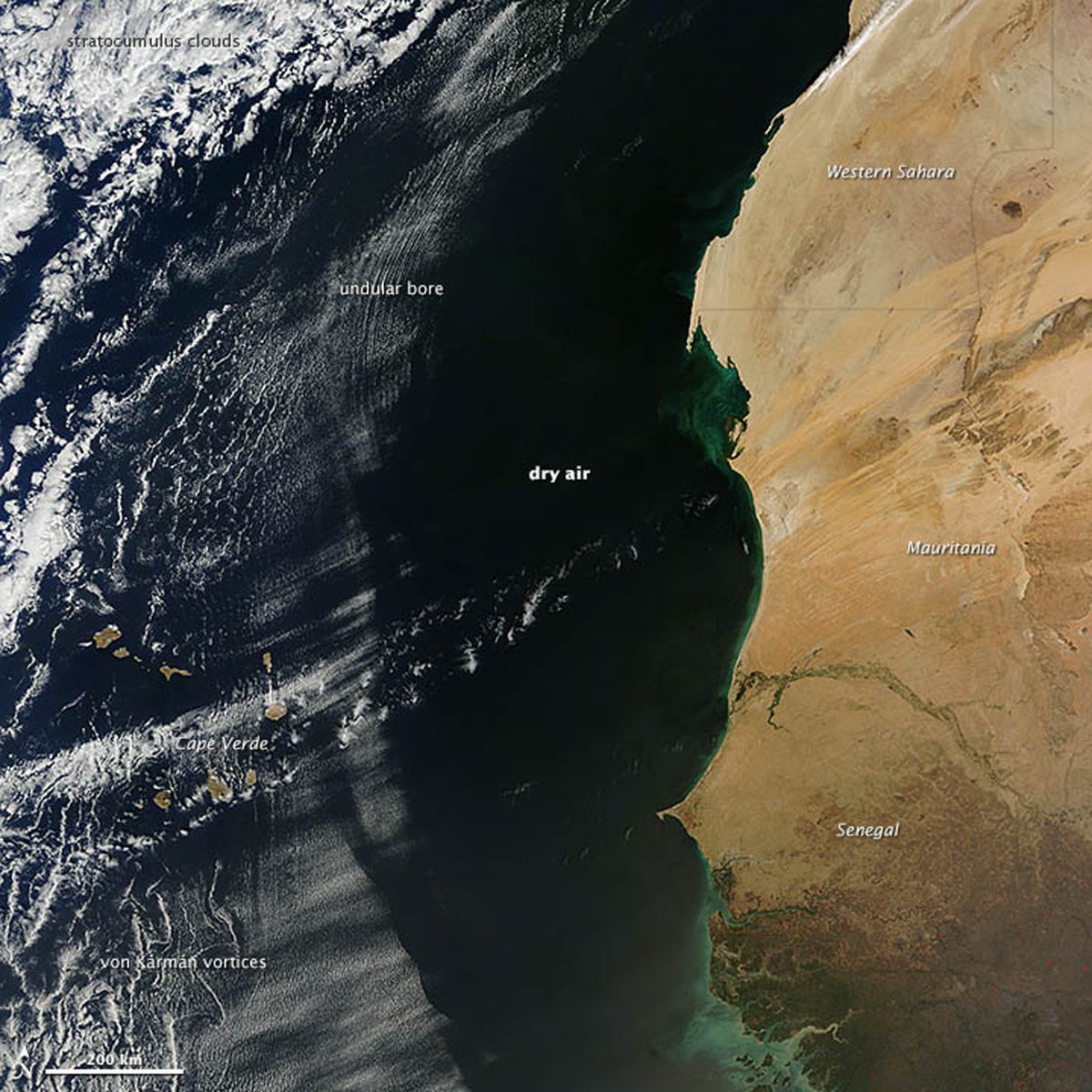
Undular bores are a type of atmospheric gravity wave. Undular bores happen when a disturbance, such as a cold front or thunderstorm outflow, triggers a series of atmospheric waves that move through a stable layer of the atmosphere. These waves travel horizontally, creating an undulating pattern that can be seen as a series of parallel cloud bands.
Etymology of “Undular Bore”
The meteorological term “undular bore” combines Latin and Old English words.
“Undular” comes from the Latin word undulatus, which translates to “wave” or “wavy.” This term aptly describes the wave-like patterns created by this atmospheric phenomenon, capturing the undulating motion seen in the clouds or water surface.
“Bore” is derived from the Old English word borian, meaning “to pierce” or “to perforate.” In the context of undular bores, it refers to the wave’s ability to penetrate through stable layers of the atmosphere, creating a series of oscillations.
Together, “undular bore” vividly describes the wave-like (undular) disturbances (bores) that propagate through different mediums, resulting in striking visual patterns.

Cloud types formed by undular bores
Here are some common cloud types that are formed as a result of undular bores.
1. Gravity Wave Clouds
- Appearance: These clouds exhibit a wave-like pattern in the sky, caused by atmospheric gravity waves. They often appear as parallel bands or ripples.
- Formation: Formed when gravity waves generated by an undular bore move through the atmosphere, causing air parcels to oscillate and form clouds along the wave crests.

2. Morning Glory Clouds
- Appearance: A dramatic and rare type of cloud formation that can stretch from horizon to horizon, often seen as a series of long, rolling cloud bands.
- Formation: Morning glory clouds mostly occur in the Gulf of Carpentaria in Australia. These clouds form when a cool air mass undercuts a warmer, moist air mass, creating a series of rolling waves in the atmosphere. The undular bore lifts moist air, which cools and condenses into clouds at the wave peaks.
3. Altocumulus Undulatus
- Appearance: Mid-level clouds appearing as parallel bands or waves, often displaying a rippled or undulating look.
- Formation: These clouds form at altitudes between 2,000 and 7,000 meters (6,500 to 23,000 feet) due to the wave motion induced by the undular bore.
4. Stratocumulus Undulatus
- Appearance: Low-level clouds that also display a wavy, layered appearance, similar to altocumulus undulatus but at lower altitudes.
- Formation: Formed when the undular bore wave interacts with a stable layer of air closer to the ground, causing the moist air to rise and create clouds at altitudes below 2,000 meters (6,500 feet).
5. Cirrus Undulatus
- Appearance: High-altitude clouds that are thin and wispy, often forming wave-like patterns.
- Formation: These clouds form at altitudes above 7,000 meters (23,000 feet) when undular bores affect upper atmospheric layers, causing ice crystals to align in wave patterns.
Wave clouds from an undular bore
During winter, swift, cool air masses often move from east to west across North Africa, pushing surges of dry air over the Atlantic Ocean. When this dry air collides with the moist and stable air over the ocean, it can create striking cloud formations.
The rippling cloud pattern in this satellite image taken off the western coast of Africa is the result of an undular bore. An advancing cool, dry air created a wave-like motion as it met the moist ocean air, pushing it upward. The motion pushes warmer air up in altitude where it condenses into clouds at the top of the wave. Descending air warms and any cloud condensation dissipates. The repetitive motion of this wave of air rising and descending creates the pattern in the clouds.

Wave clouds off Baja California
On October 4, 2020, NASA’s Terra satellite captured an image of undular bores creating wave-like cloud patterns over the Pacific Ocean near Baja California. These clouds form when masses of cool and warm air collide, with the cool air pushing the warmer air upward. This interaction creates atmospheric gravity waves, leading to parallel bands of clouds where the air rises and clear spaces where the air descends. The rugged terrain of Guadalupe Island further influenced these cloud patterns, creating pockets less conducive to cloud formation.
As the undular bores moved across the Pacific, they generated striking cloud bands visible from space. These formations, often referred to as wave clouds or undulatus, are created when air masses are forced upward by topographical features or other disturbances, causing the air to cool and moisture to condense into clouds. The resulting wave pattern, with alternating crests and troughs, produces the distinctive, rippling cloud structures observed in the satellite image.

References
Constantin, A., & Johnson, R. S. (2024). Atmospheric undular bores. Mathematische Annalen, 388(4), 4011-4036. DOI: /10.1007/s00208-023-02624-8.
Smith, R. K., Roff, G., & Crook, N. (1982). The Morning Glory: An extraordinary atmospheric undular bore. Quarterly Journal of the Royal Meteorological Society, 108(458), 937-956. DOI: /10.1002/qj.49710845813
