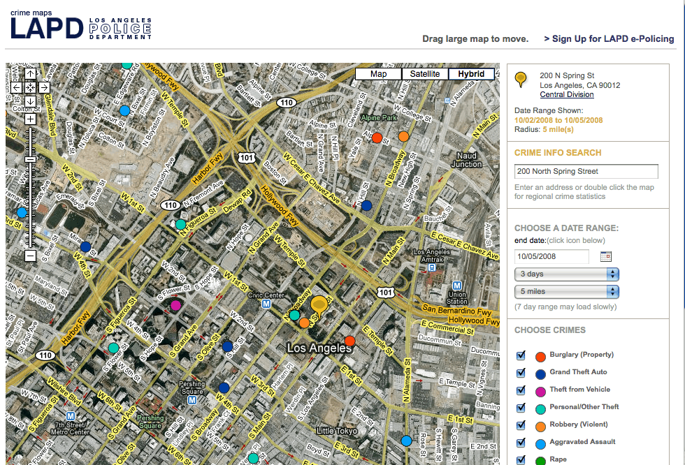
The advent of easy-to-use GIS applications has allowed crime mapping and analysis to flourish within law enforcement agencies. Software, training and resources are easily available to those interest in this use of GIS.
Sara Barbour from Miller/McCune magazine writes a summary article on the use of GIS to predict criminal behavior in GIS: Cops Favor New Kind of Plotting. The start of the article reviews a crime case in which spatial analysis was used to pinpoint and subsequently arrest a sex offender in Toronto. Manny San Pedro, an officer with that police force is quoted as saying “If you have a crime analysis unit and you are not using spatial analysis, you are missing a key component.” The article also delves into how a generation raised on Google Maps will maybe one day find spatial thinking added to their curriculums.
See Also
- Geographic Profiling – The geographic profiling concept proposes that criminals tend to commit acts of crimes within a comfort zone located near but not too close to their residence.
Predictive Policing
Most crime analysis produces maps and statistics for crimes that already have occurred. The Los Angeles Times has an article about predictive policing which looks to analyze when and where crimes are the mostly likely to occur. George Mohler, a professor in the Department of Mathematics and Computer Science at Santa Clara University, has adapted math formulas used to calculate aftershocks. Mohler, using the phenomenon that homes in an area that has already been burglarized are more likely to also be burglarized (called an exact or near-repeat effect), has developed a computer model to can accurately predict the likely occurrence of crime in a given neighborhood in Los Angeles.
Read more:
Stopping crime before it starts – Los Angeles Times
Crime Modeling and Prediction – George Mohler

Crime as Elevation
What would the topography of San Francisco look like if elevation was based on crime? Doug McCune took at look at the spread of crime in San Francisco using data for the entire year of 2009 which he downloaded from DataSF. The 3D results are displayed on his web site and make for some interesting observations about the geographic distribution of crime in the city. McCune provides top-down and oblique views of his 3D mapping. While all of the crimes mapped have distinct areas where the crime is more concentrated, some of the crimes have sharper concentrations than others. The most obviously clustered crime is prostitution with high peaks.
Read more: If San Francisco Crime Were Elevation
(Tip: Carmen)

How to Hire a Crime Analyst
The Police Foundation has developed a free publication entitled “Selecting the Best Analyst for the Job: A Model Crime Analyst Assessment Process for Law Enforcement Agencies.” Written by Karen L. Amendola and Greg Jones and published in December of 2010, the book is available online via PDF format.
The abstract:
The rapid growth in applications and usage of crime mapping and analysis in law enforcement agencies in recent years has increased job opportunities for new analysts. Recognizing the importance of creating hiring standards and a systematic and comprehensive hiring process for selecting highly capable crime analysts, and with the support of the Office of Community Oriented Policing Services, the Police Foundation developed Selecting the Best Analyst for the Job: A Model Crime Analyst Assessment Process for Law Enforcement Agencies (CAAP). The publication and CD-ROM focus on defining the job of a crime analyst and on a model procedure for selecting the best possible crime analyst for an agency.
The Police Foundation has many other publications and resources available on their Publications page.
Visit: http://www.policefoundation.org/docs/caap.html
More Crime Mapping Resources
Carolinas Institute for Community Policing
Organization focused on promoting community policing, with GIS mapping as its specialty. Find resources such as training, software and case studies from this web site.
Crime Analysis and Mapping Program
The Crime Mapping and Analysis Program (CMAP) provides technical assistance and training to state and local agencies in crime and intelligence analysis and geographic information systems. Find information on training classes.
Crime Mapping: GIS Goes Mainstream
While GIS is still a firm member of the “What is that?” club, it is making a solid foray into the mainstream. This now defunct crime-fighting CBS series “The District” introduced GIS to primetime and the concept of COMSTAT.
Curiosity Quest
Curiosity Quest trains law enforcement personnel in the art and science of crime mapping and analysis. Curiosity Quest also offers a variety of tools and resources for incorporating Mapping into police vehicles.
Esri GIS in Law Enforcement
ESRI page focusing on the use of GIS in law enforcement. Find information on how to use GIS in many areas of crime analysis and law enforcement. Links to case studies.
A Guidebook for Measuring Crime in Public Housing with GIS
Downloadable Microsoft Word Document from Housing and Urban Development’s (HUD) Office on using GIS for crime analysis.
Journalistopia’s Crime Mapping Directory
Danny Sanchez over on the Journalistopia blog has a pretty extensive roundup of online crime mapping applications covering agencies and private endeavors around the United States.
National Institute of Justice’s MAPS ProgramResource intensive site from NIJ containing information about crime analysis. Of interest is a PDF paper on “Understanding Hot Spots”. Visitors can also join the CimeMap Listserv.
Police Foundation
This organization works to advance the understanding of computer mapping, to pioneer new applications in mapping, and to assist law enforcement agencies seeking to incorporate mapping/GIS into their operations.
Social Science Computer Review
The May 2007 issues (Volume 25, Number 2) of the journal Social Science Computer Review is focused on crime mapping. Journal topics range from software reviews such as a review of CrimeStat III to articles on spatial and statistical analysis in crime mapping.
Spatial Analysis of Crime Using GIS-Based Data
Dissertation outlining specifications for utilizing data and data analysis tools such as GIS for aiding Community Oriented Policing in crime reduction.
Suggest a resource by emailing editor@gislounge.com


 The rapid growth in applications and usage of crime mapping and analysis in law enforcement agencies in recent years has increased job opportunities for new analysts. Recognizing the importance of creating hiring standards and a systematic and comprehensive hiring process for selecting highly capable crime analysts, and with the support of the Office of Community Oriented Policing Services, the Police Foundation developed Selecting the Best Analyst for the Job: A Model Crime Analyst Assessment Process for Law Enforcement Agencies (CAAP). The publication and CD-ROM focus on defining the job of a crime analyst and on a model procedure for selecting the best possible crime analyst for an agency.
Is there any course for
Crime mapping and analysis.