
Lowell Ballard, Director of Geospatial Technology for Timmons Group, discusses why preventing scope creep is important for creating GIS apps that are focused, easy to use, and easy to understand.
The toughest part of building a great application is knowing what to exclude.
I spend a lot of time presenting ideas to both technical and non-technical people. These meetings typically revolve around developing applications (solutions) for an eventual end-user community or set of key stakeholders.
As a client and consultant team working together we try to do our best to understand how the end-user will ultimately use the application. Typically, the longer the conversation lasts, the further we get away from the core of the users’ needs.
So why does this happen?
In my experience, everyone knows what the core user needs almost immediately. These needs are front-and-center in their minds and very easy to explain. However, almost invariably, the discussion tends to evolve from there, expanding to include lower priority needs.
The longer the discussion – the further we get away from the initial core goals for the project that will really help users most. Initially, this is a positive aspect for any discussion; however, we have to remember that the first “asks” are probably the most important and should be prioritized to be given the most design and development consideration.
Developing a Parcel Map Application
Let’s take a very simple example of a solution that would allow a user to look up your land property record.
Most local governments map out parcel information and desire to provide a website to reduce office traffic and phone calls and provide this information to realtors, residents, and locality staff. In short, they want to leverage technology to better meet the needs of their stakeholders and internal staff.
Most of us have used a site like this in the past. In the first five minutes, the project team can typically identify the 20% of functionality that users need 80% of the time.
Instead of stopping there, we continue to talk, map out ideas, and begin to “clutter” the solution with lower priority items. For every new feature we incorporate – we potentially complicate the user experience.
For every new feature we “add”, we have to find a place to “fit” it into the application. If we’re not careful, as more features are added, we lose the ability to create “workflows” targeted at specific outcomes and streamlined solutions for our GIS users.
Preventing Project Scope Creep
Let’s return to our property look-up site.
As a project team, we can collectively come up with some key requirements in short order. For example, the user needs to be able to input an address and get back information about the property located there.
Once we move past these initial requirements, discussions drift to features that stray away from the “core 20%”.
Functionality, such as the ability to measure area, begins to drift into the solution. Then measuring area drifts into measuring distance. Then, measuring by distance and area drifts into a discussion of which units of measurement to use.
So now we have requirements to measure by line and polygon and to be able to control the units (e.g., meters, feet, etc.). All of these features may very likely provide value; however, they also now potentially have the same sense of priority and need to be “fit” into the user interface and ultimate solution.
Without intervention, the solution will move forward and potentially miss the mark.
Focus on the 20% of features that Users Need 80% of the Time
As professionals, it’s our responsibility to recognize this tendency and work hard to focus on the core 20% of features that users need 80% of the time.
This way we can develop an application that is focused, easy to use, and easy to understand. It’s very difficult for us to limit ourselves and stay attached to the main reasons users are coming to the application.
Users are much more forgiving if you provide them a focused set of features that perform well and provide them with simple outcomes. We will cover some ideas to help in the development of these solutions; how to keep solutions streamlined and simple; and how to better serve our stakeholders in future articles.
The images included illustrate our revised approach at Timmons Group to building these property mapping sites. The interface is streamlined to support a few key, high-priority functions and is built to “respond” appropriately based on the user’s device (e.g., smartphone, tablet, and desktop browser).
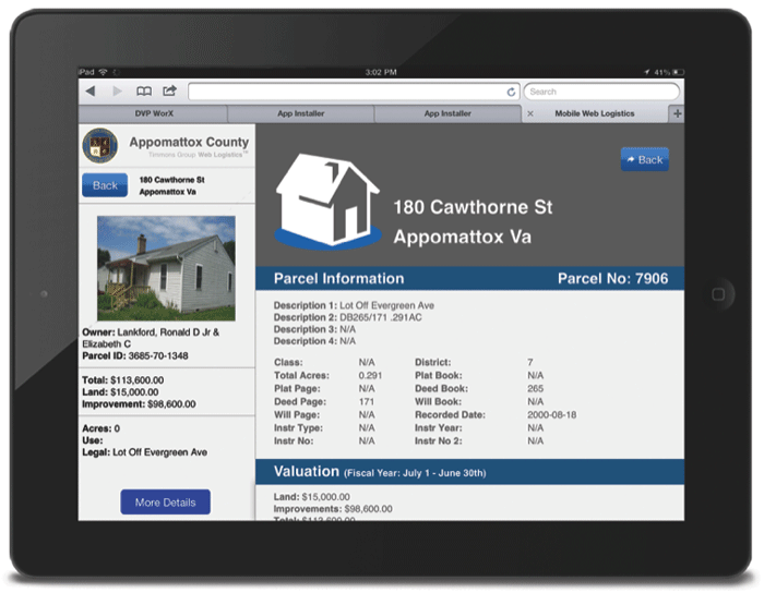

Create a responsive property mapping application that reads easily for users that may access it from a smartphone. Images: Timmons Group
Read next: GIS for Local Government: Economic Development and Site Selection