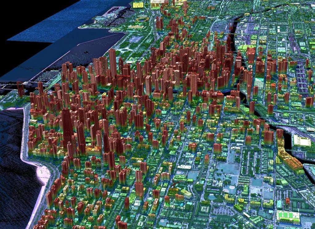
Geiger-mode lidar is a new generation of remote-sensing technology called lidar—an acronym for Light Detection And Ranging—used to collect high-accuracy elevation data.
Lidar works in much the same way as radar but uses light waves instead of radio waves to measure ranges from one object, such as an airplane, to another object, such as the earth below. It does this by emitting short laser pulses toward an object and then measuring the time it takes for the light to reflect off the object and return. This enables a calculation of the object’s distance.
Lidar was conceived in the 1930s as a method of using light to probe the atmosphere. The first prototype was built in 1961 by the Hughes Aircraft Company, which had built the first laser a year earlier.
Once lidar became a reality, NASA put it to use in earth sciences and planetary exploration programs. In 1971, For example, NASA used lidar to map the moon during the Apollo 15 mission.
In 1994, NASA used lidar on the space shuttle Discovery to study the constituents of the earth’s atmosphere, from cloud droplets to industrial pollutants, which are difficult to detect by other means. In 2001, the Mars Global Surveyor used lidar to produce a precise topographic map of that planet, which has been critical to the success of subsequent missions to Mars.
Lidar technology took a giant leap forward with the advent of Geiger-mode lidar, which features a more complex sensor system and lower laser-energy requirement. Initially used exclusively for military purposes, it has now come onto the commercial market, enabling aerial surveys to be conducted with unprecedented flight altitude and area yield, dramatically lowering the cost of geospatial data acquisition.

Traditional linear-mode lidar systems repeatedly fire a single high-powered laser pulse. This can be problematic because vegetation or other surface features can break the beam into multiple return signals or block it entirely.
Geiger-mode lidar, in contrast, uses a photo diode array to flood an area with infrared light. Each diode in the array is sensitive enough to detect a single photon reflected from the illuminated area. The array is mounted on a scanner that rotates at an angle to create a cone-shaped field of view.
This results in a circular ground field of view rather than a line as with linear-mode lidar. As the scanner rotates, the photo diode array flashes up to 50,000 times every second and takes 4,096 measurements per flash, which equates to 205 million samples per second. As a result, each square meter of terrain can be sampled thousands of times in a single over-flight.
Dense illumination of the surface allows Geiger-mode lidar to see through obscurants like trees and other vegetation. Moreover, Geiger-mode lidar can be flown at altitudes of up to 45,000 feet, creating a larger ground swath for the sensor, allowing faster data collection.
Geiger-mode lidar’s speed and affordability make periodic monitoring practical. Utilities, for example, can now use it more often to monitor power-line corridors for vegetation encroachment, a major cause of line failures and power outages costing economies billions of dollars annually. The technology is also helping to design smarter cities, improve transportation systems, maintain utility infrastructure, and to plan wind and solar farms more efficiently.
The Geiger-mode Avalanche Photodiode was first developed at MIT’s Lincoln Laboratories by Richard Marino. After more than 15 years of helping to refine this technology for the Department of Defense, Harris Corporation, an American defense contractor, introduced the first commercially available Geiger-mode lidar sensor in 2015, shortly after it was declassified. VeriDaaS Corporation, a Denver-based geospatial solutions company, acquired the first Geiger-mode lidar systems from Harris.
VeriDaaS now uses the technology in private-public partnership with the U.S. Geological Survey (USGS) to advance the national 3D Elevation Program (3DEP), which is collecting elevation data across the United States as part of the broader National Geospatial Program, which aims to provide a foundation of digital geospatial data representing the topography, natural landscape, and manmade environment of the United States. The program supports a wide range of applications, including projects related to energy infrastructure construction and safety. 3DEP is expected to generate $13 billion in new economic benefits yearly through applications that span the economy.
References
Marino, R. M., & Davis, W. R. (2005). Jigsaw: a foliage-penetrating 3D imaging laser radar system. Lincoln Laboratory Journal, 15(1), 23-36. Retrieved from https://www.ll.mit.edu/sites/default/files/page/doc/2019-01/15_1jigsaw.pdf
About the Author
Paul Nash, MA, PhD is a strategic communications professional. He obtained his PhD from the University of Edinburgh and is a member of the Canadian Coast Guard Auxiliary, serving as director of a search and rescue unit in the Central and Arctic region.
