
A piedmont glacier is a valley glacier which has spilled out onto relatively flat plains, spreading into bulb-like lobes. These glaciers often form when the ice reaches lower altitudes and the landscape opens up, allowing the glacier to spread out, rather than being constrained by the steep valley walls.
Formation of Piedmont glaciers
Piedmont glaciers begin their journey high in the mountains as valley glaciers, where they are confined to narrow valleys formed by past tectonic activity or erosion. As these glaciers advance downhill, they maintain a relatively linear shape. Once they reach flatter terrain at the base of the mountains, their shape begins to spread out. The decrease in the slope allows the ice to flow more freely, creating the signature bulbous, fan-like structure that defines a Piedmont glacier.
Alaska’s Largest Glacier
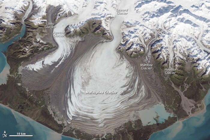
The largest piedmont glacier in North America, and outside the polar regions, is in found in southeastern Alaska and is known as the Malaspina Glacier. Malaspina Glacier is also Alaska’s largest glacier and lies west of Yakutat Bay in Wrangell-St. Elias National Park.
This piedmont glacier is 65 km (40 mi) wide and 45 km (28 mi) long, with an area of about 3,900 square kilometers (1,500 square miles).
How the Malaspina Glacier got its name
The glacier is named after Alessandro Malaspina, an Italian explorer with the Spanish Navy who visited the area in 1791. The glacier was named after the explore in 1874 by William Healey Dall of the then named United States Coast Survey. The indigenous name for the Malaspina Glacier is Sit’ Tlein which is Tlingit for “big glacier.”
Malaspina Glacier was designated as a National Natural Landscape in 1968.

Compound Glacier
Malaspina Glacier is a compound glacier, formed by the merger of several valley glaciers. The Malaspina is divided into three lobes. The western lobe of the Malaspina is formed by the Agassiz glacier, the center lobe by the Seward glacier, and the eastern lobe by the Marvine glacier.
This perspective view of Malaspina Glacier was created from Landsat satellite imagery and topography from Shuttle Radar Topography Mission (SRTM). This color composite shows glacial ice in light blue, snow in white, vegetation in green, bare rock in grays and tans, and the ocean (foreground) in dark blue. Agassiz Glacier is on the left and Seward Glacier is on the right with Malaspina Glacier in the middle.

Moraines
In the Landsat image below, the brown lines are due to moraines. Moraines caused surges in the depositing of soil and rock debris by the moving glacier, forming brown ripples along the edges of the piedmont glacier.

The moraines’ curves and zig-zag pattern are created when the glacier “surges.” Glaciers in this region of Alaska “surge” on a periodic basis, lurching forward rapidly for one to several years. As a result of this uneven flow, the moraines along the borders and between glaciers can get folded, crushed, and sheared, resulting in the Malaspina’s unique loops.
The Inter-mission Time Series of Land Ice Velocity and Elevation (ITS_LIVE) research initiative calculated ice velocities for the valley glaciers that form the piedmont glacier fan. Velocities for the Melaspina glacier were compared between 1997 and 2017 using Landsat satellite imagery. With blue for slower moving areas and yellow for the highest speeds, the two maps show how different glaciers in the area experience surges in ice flow.

This article was originally written on July 13, 2016 and has since been updated.
References
AGU research spotlight: Student’s research provides insight into world’s largest Piedmont glacier. (2021, December 14). Geophysical Institute. https://www.gi.alaska.edu/news/agu-research-spotlight-students-research-provides-insight-worlds-largest-piedmont-glacier
Hansen, K. (2015, October 11). Malaspina glacier, Alaska. NASA Earth Observatory. https://earthobservatory.nasa.gov/images/86767/malaspina-glacier-alaska