
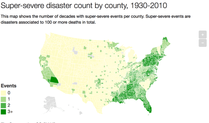
A team of researchers gathered ninety years of data from the American Red Cross and federal agencies like the Federal Emergency Management Agency (FEMA). The data, collected at the county level, looks at the incidents of earthquakes, hurricanes, tornadoes, floods, and other severe natural disasters between 1920 – 2010.
The occurrence and types of natural disasters varies across the geography of the United States. The areas of Florida and the Gulf of Mexico are impacted by hurricane season. Winter storms hit New England and the Atlantic seaboard. California experiences wildfires and periodic earthquakes. The Midwest has Tornadoes while the Mississippi River floods neighboring counties.
The authors of the study wanted to learn how the severity of natural disasters affects the migration of people in the United States. The authors founded that super-severe disasters, defined as natural hazard events that result in at least 100 deaths, are more likely to result in migration to safer areas than smaller natural disasters. With climate change creating more frequent severe weather patterns, the authors are concerned that this trend will “worsen inequality in the U.S., as the rich move away from disaster-prone areas, while the poor are left behind.”
More:
- New data set explores 90 years of natural disasters in the US – The Conversation
- Boustan, L. P., Kahn, M. E., Rhode, P. W., & Yanguas, M. L. (2017). The Effect of Natural Disasters on Economic Activity in US Counties: A Century of Data (No. w23410). National Bureau of Economic Research.
