
Update: January 30, 2021: Version 3.2 of Quantarctica was released today.
Quantarctica is a collection of freely downloadable GIS data for Antartica which includes “community-contributed, peer-reviewed data from ten different scientific themes and a professionally-designed basemap.“
The Quantarctica package is released under a a Creative Commons Attribution 4.0 International License. All data in the package includes metadata in order to see the individual attribution requirements necessary. It’s important to check the different licenses, terms of use, and attribution requirements as they vary among the individual datasets.

Previous (Originally published in March of 2014):
A QGIS specific free GIS dataset is available for downloading from the Quantarctica site (QGIS + Antarctica). The GIS data contains geography, glaciology and geophysics data originally developed for in-house use at the the Norwegian Polar Institute.
Quantarctica was first released for public consumption in July of 2013 and there are plans to expand the data offerings with contributions from the research community. The data is free for noncommercial use.
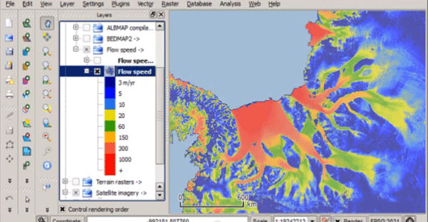
Users can download a base package which is 7GB in size. The base package includes GIS base map vector and raster data, and scientific data covering geophysics and glaciology. Geography data includes place name, facility, grounded ice, ice shelf, and outcrops. Glaciology data includes ice thickness, ice-flow speed, and subglacial lakes. Geophysics data includes geoid heights, and magnetic anomalies.

The data is available at a range of scales from continental to local.
QGIS 1.8 is also bundled in the package. Those users that want to individually download Quantarctica’s datasets can do so via the Quantarctica FTP server. Also available from the download page are high resolution imagery datasets such as Landsat MOS and RADARSAT images.
Users can sign up at the bottom of the home page with their email addresses to receive updates to the Quantarctica site.