
satellite imagery

36,500 Satellite Images from RADARSAT-1 Now Available to the Public
The Canadian Space Agency and the Canada Centre for Mapping and Earth Observation have released RADARSAT-1's archive of 36,500 satellite images to the public.

NASA Satellite Captures Image of Meteor Over the Bering Sea
On December 18, 2018, the Multi-angle Imaging SpectroRadiometer (MISR) instrument on NASA's Terra satellite detected the aftermath of an explosion of a fireball (a very bright meteor) 16 miles (26 kilometers) over the Bering Sea.

LandViewer Has Added New Remote Sensing and Satellite Imagery Analytics
This article by EOS, a company which creates solutions for Earth observation imagery processing and analysis, introduces a host of updated capabilities in its LandViewer tool.

The First Color Images of the Earth from Space
The first color photographs of the full-disk view of the Earth were taken in 1967

What are the Benefits of Landsat’s Current Free and Open Policy?
A group of researchers from different universities and government groups have published a study of how Landsat's free and open data policy has benefitted users of the programs satellite imagery products.

ICESat-2: Highest Resolution Laser Altimeter
ICESat-2's purpose is to collect detailed measurements of the Earth's surface using its Advanced Topographic Laser Altimeter System (ATLAS).
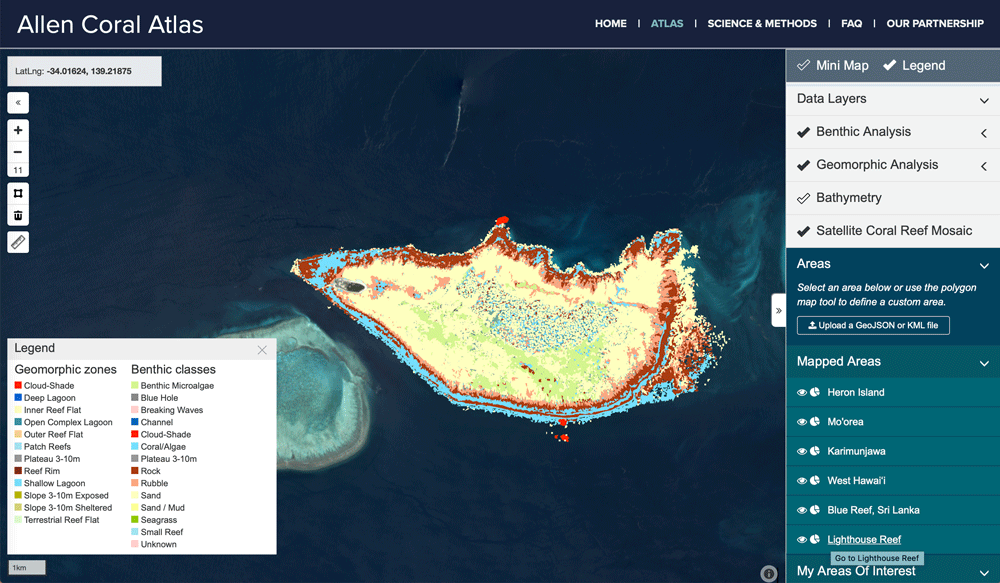
Mapping Coral Reefs
Scientists have been developing better ways to fuse data from different satellite systems and data capture, while also developing classification algorithms to better map coral reefs.

Using Satellite Imagery to Track Volcanic Ash Clouds
Researchers have developed an algorithm that can distinguish between volcanic and non-volcanic clouds using high-resolution satellite imagery.

Creating Ground-level Views from Satellite Imagery
Recreating a ground-level image and perspective using satellite imagery has only recently been developed.

Using Drones and Remote Sensing for Mapping and Counting Animals
Remote sensing data from satellite and UAV imagery has been used by researchers in the mapping and observation of wildlife, in particular counting the number of animals in remote locations.

Transforming Satellite Imagery Classification with Deep Learning
Deep learning has a potential to transform image classification and its use for the spatial sciences, including GIS.

Developing Damage Proxy Maps from Satellite Data
Satellite data is being used to create Damage Proxy Maps to assess changes in an area as the result of natural disasters like Hurricane Maria in Puerto Rico, and the wildfires that have hit Northern and Southern California.

Map of Cold and Hot Temperature Anomalies Across the World
NASA has compiled a temperature anomaly map of the world using data acquired between December 26, 2017 and January 2, 2018.

Watch Landsat 8 Imagery Acquisition in Near Real-time
The FarEarth Global Observer offers visitors the opportunity to view near-live streams of Landsat 8 imagery being acquired in near real-time.

The USGS Landsat Analysis Ready Data (ARD) Program
Landsat data, referenced with WGS84 and provided as GeoTIFF, can be accessed from EarthExplorer for the contiguous US, Alaska, and Hawaii.

Hurricane Ophelia is the Strongest Hurricane to Form East of the United States
On Saturday, October 15, 2017, Hurricane Ophelia strengthened to Category 3 status making it the first recorded eastern hurricane to be this strong.
Automated Land Cover Maps
Automating the generation of land cover maps from satellite imagery is becoming easier due to learning-based algorithms improving the understanding of signal data.

Tracking Hurricane Harvey with Satellites
Several satellites have been tracking and measuring the intensity of Hurricane Harvey.

Coral Bleaching of the Great Barrier Reef
The Great Barrier Reef has undergone two severe bleaching events in successive years. This has been caused by the warming of the oceans due to climate change.

How This Remote Island Inhabited by Polar Bears Became Known as Landsat Island
Discovered in 1976 in imagery captured by Landsat 1, Landsat Island (60° 10' 37"N, 64° 02' 30"W) is solely populated by polar bears.

3.1-Trillion Pixel Landsat 8 Mosaic of the World
Descartes Labs has compiled some of the massive amount of data sent back from the satellites orbiting Earth into a 3.1-trillion pixel composite image of Earth’s surface.

View the Human Footprint on this Rotating Globe
View the global human footprint map developed from 180,000 satellite images.
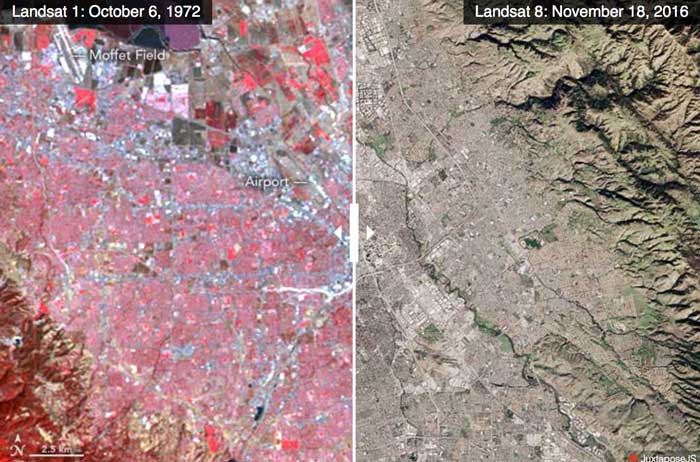
Advances in Landsat Sensors
Since those first images in 1972, multiple Landsat satellites have been launched with the ability to take increasingly detailed pictures of our world.

Open Data Program Launched by DigitalGlobe
The Open Data program offers high-resolution satellite imagery and crowdsourced GIS layers for large-scale natural disasters.

Helping Chimpanzee Conservation Efforts with Satellite Imagery
NASA has partnered with the Jane Goodall Institute to provide satellite imagery and the analysis needed to understand where habitat loss is the most extreme to protect chimpanzees in the wild.

Learn How to Access and Use Sentinel-3 Data
Learn how to download and use earth observation data from ESA's Sentinel-3 satellite.