
Along with the more well-known islands like the Aleutian and Hawaiian Islands, the United States is home to thousands of islands found much closer to the mainland, scattered along coastlines, tucked inside estuaries, and forming barrier islands that separate coastal wetlands from the open ocean.
Researchers from the U.S. Geological Survey (USGS), Esri, The Nature Conservancy, and several other organizations developed the first-of-its-kind geographic inventory to better understand where U.S. islands are located, what ecosystems they support, and their importance for protecting biodiversity.
They found that U.S. islands, with a combined land area equal to about 2% of the mainland, overlap the ranges of more than half of the country’s threatened and endangered species.
Mapping the islands of the United States
Using geographic information systems (GIS) and satellite imagery, the researchers identified more than 19,000 islands associated with the United States and its territories.

This GIS database of U.S. islands was developed using Landsat satellite imagery at a spatial resolution of 30 meters. Researchers organized the islands into 12 geographic regions and 28 smaller island provinces, including the Alexander Archipelago in Alaska, the Hawaiian Islands, the Mississippi Delta, and the islands of Puerto Rico and the U.S. Virgin Islands.
The inventory does not include islands in lakes and rivers. It also excludes islands smaller than 3,600 square meters (about 0.89 acres) from the main analysis because they fall below the study’s reliable mapping threshold. This means the actual number of islands in the United States is higher than the study’s count.
Most U.S. islands are not remote oceanic islands
Most of the of islands in the inventory lie on the North American continental shelf. The researchers classified 96% of the mapped islands as continental islands, meaning they are located on the shallow, submerged margins of the North American continent. Only 4% were classified as oceanic islands, which lie beyond the continental shelf and are typically volcanic in origin.

The study also found that approximately 88% of the islands are estuarine islands, located in or near areas where freshwater and seawater meet. These include islands along the Atlantic and Gulf coasts, where tidal channels, wetlands, and sediment deposition create complex coastal landscapes.
U.S. Islands are rich in biodiversity
Published in January 2026 in the Annals of the American Association of Geographers, the study also examined the distribution of threatened and endangered species across U.S. islands.
To evaluate the conservation importance of these islands, researchers combined their island maps with geographic data showing the known or estimated ranges of species protected under the Endangered Species Act. U.S. islands contain the mapped ranges of 52% of the nation’s federally listed threatened and endangered species.
Of the 1,578 federally listed threatened and endangered species with available geographic range data, 828 species, or 52%, had ranges that overlapped one or more U.S. islands. A total of 617 of these species had mapped U.S. distributions exclusively on islands, with no mapped occurrence on the continental mainland. For these species, conserving island habitats is essential to their protection within the United States.
The geographic isolation of islands helps explain their importance. Populations separated from mainland habitats can evolve independently over long periods. This process can produce endemic species, meaning species that naturally occur in only one geographic area.
At the same time, island species can be particularly vulnerable to habitat destruction, invasive species, and other environmental changes. Species restricted to a single island or island group have fewer opportunities to move elsewhere when their habitats are disturbed.
Which U.S. islands have the most threatened and endangered species?
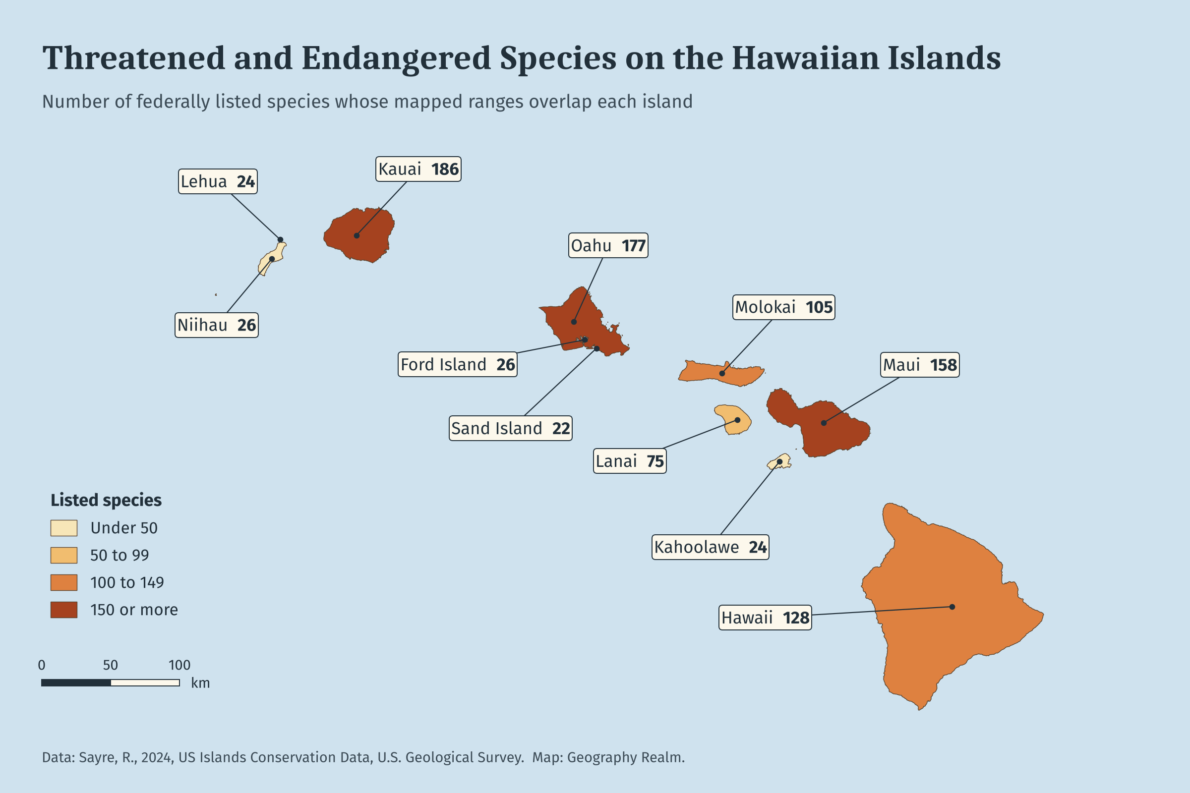
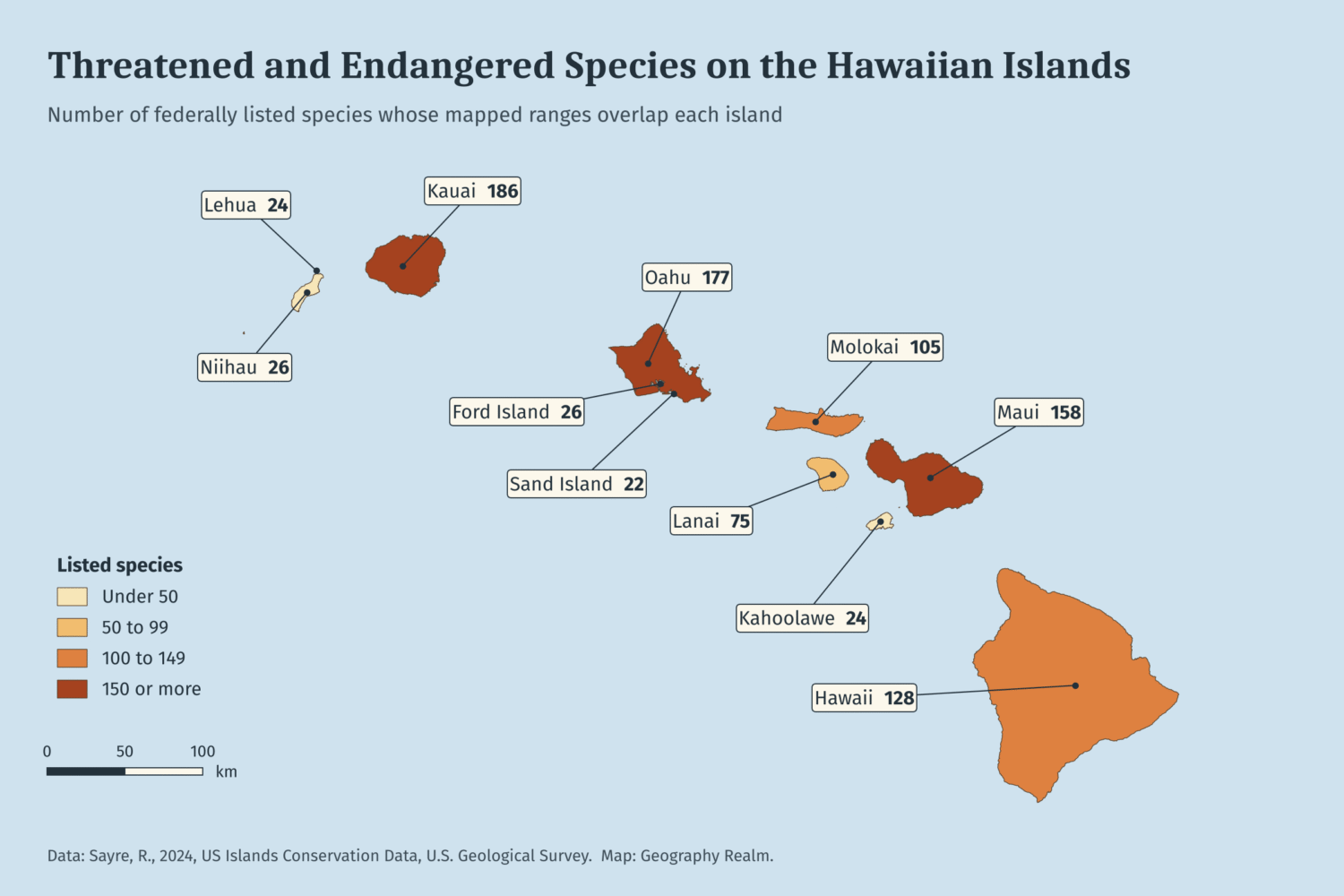
The Southeast Hawaiian Islands had the highest concentration of threatened and endangered species and ecosystem diversity. Researchers identified mapped ranges for 487 federally listed threatened and endangered species in this island province, along with 83 distinct terrestrial ecosystem types.
Other island provinces also support substantial numbers of listed species.
| Island province | Threatened and endangered species |
|---|---|
| Southeast Hawaiian Islands | 487 |
| Southern California Current | 76 |
| Puerto Rico and Virgin Islands | 73 |
| South Atlantic | 70 |
| Florida Shelf | 63 |
| Southern Mariana Islands | 40 |
These figures represent species whose mapped ranges intersect the islands in each province, rather than confirmed observations of every species on every island.
Islands are also important for migratory birds
The researchers also compared the islands against the ranges of birds protected under the Migratory Bird Treaty Act. Every island province along the continental coast sits within one of North America’s four major flyways: the Pacific, Central, Mississippi and Atlantic. Those areas had far more migratory bird species than the remote ocean islands. The Texas Shelf islands, in the Central Flyway, had the most species at 353. Wake Island, in the middle of the Pacific, had 41.
While remote islands still matter to birds as nesting grounds, especially for seabirds, coastal islands offer something different, which is habitat along the routes birds travel between their breeding and wintering areas. That makes them worth protecting for the birds passing through as well as for the species that live there all year.
How much island land is protected varies widely
The researchers also looked at how much island land is already protected. They compared the island boundaries with the USGS Protected Areas Database of the United States and calculated the percentage of each island that falls within a protected area.
The results differ sharply from one part of the country to another. In Alaska’s Alexander Archipelago, 89% of island land is protected. In Puerto Rico and the U.S. Virgin Islands, protected areas are 8%. The Alexander Archipelago islands overlap the mapped ranges of two threatened and endangered species, while Puerto Rico and the Virgin Islands overlap 73 species.
Hawaii has varying levels of protected areas from island to island. All of Kahoolawe is protected, compared with 45% of Kauai, 23% of Oahu, and none of Niihau.
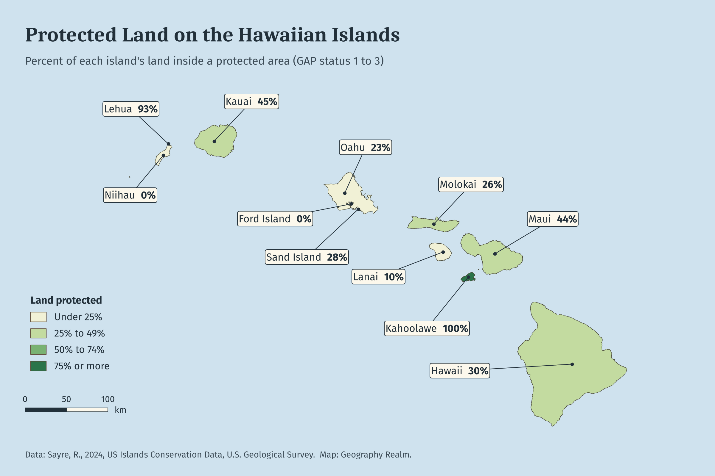
Protected status does not guarantee that the land is well managed. The study’s authors note that the effectiveness of conservation management on U.S. islands is unknown
U.S. Island GIS data available
The researchers released their U.S. island inventory as a free dataset for mapping and spatial analysis. The data is available as a GeoPackage (GPKG), an ArcGIS Pro map package (MPKX), and an Excel spreadsheet.
The attributes for each island include its size, whether it is continental or oceanic, the terrestrial and coastal ecosystems found on it, the threatened and endangered species and migratory birds whose ranges overlap it, and any protected areas. The data can be analyzed for a single island, an archipelago, or a whole stretch of coast.
The authors list several limitations. The size cutoff leaves out many sea stacks and rocky outcrops where seabirds nest. Species were assigned to islands wherever a mapped range overlapped one, so a species may be listed for an island where it doesn’t actually occur. The authors recommend checking the data in the field before using it for decisions about a specific island.
Small islands stand to gain the most from the inventory. Islands larger than one square kilometer are conspicuous and likely already part of a management plan. The roughly 17,500 smaller islands may never have been accounted for, and each of them now has a mapped boundary and a record.
The study
Sayre, R., Martin, M., Naji, N., Sides, K. B., Cress, J., Butler, K., VanGraafeiland, K., Karagulle, D., Frye, C., Breyer, S., Wright, D. J., Klavitter, J., Spatz, D., Will, D., Howald, G., Wegmann, A., Stanley, C., & Holmes, N. (2026). A new inventory and conservation assessment of United States islands. Annals of the American Association of Geographers, 116(5), 1083-1106. https://doi.org/10.1080/24694452.2025.2604843
Sayre, R. (2024). A New Inventory and Conservation Assessment of United States Islands [Dataset]. Zenodo. https://doi.org/10.5281/zenodo.10672139
