
Remote sensing methods are being used to monitor thermal radiation in European cities. Hardscape surfaces such as roof tops and concrete pavement absorb solar radiation during the day and retain that heat longer than softscape surfaces such as vegetation. This phenomenon is known as an urban heat island and the contrast can most notably be measured at night.
The European Space Agency’s center for Earth observation (known as ESRIN) has been looking out how thermal radiation modeling using satellite sensors can be used to predict urban heat islands. ESRIN’s Urban Thermography team analyzed ten years worth of satellite data covering the European cities of Athens, Bari, Brussels, Budapest, Lisbon, London, Madrid, Paris, Seville and Thessaloniki in order to understand patterns of nightly heat retention.
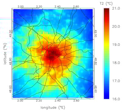
The difference in mean temperatures can be quite significant. The image above shows mean temperatures for the city of Paris, France taken at 10pm local time. The highest mean temperatures in the core of the city were measured at five degrees higher than the outer, less urbanized areas.
Understanding the patterns of the urban heat island effect can be used to help city planners and safety officials understand how to mitigate the impact of higher temperatures in urban areas. Heat related deaths rise significantly during periods of elevated heat and planning ways to dissipate the heat at night can play an important role in reducing those deaths. The heatwave that impacted in Europe in 2003 resulted in over 35,000 deaths.
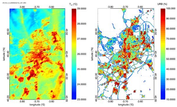
The image above demonstrates the effect of vegetated areas on minimizing urban heat islands. In the middle of each image (contained within the center of a rectangular outline) is Retiro Park in Madrid, Spain (the cropped area is also shown below). The left image shows the air temperature for Madrid as measure on June 25, 2008 at 22:18 UTC and the right image shows the sealed soil surfaces percentage. The park is noticeably cooler and demonstrates the impact that vegetated areas such as city parks can have on reducing nightly thermal radiation.
