
Remote or difficult to reach areas can make using traditional mapping methods, with total stations, theodolites, or even ground control points (GCPs), difficult or more complex. By improving the precision of the GPS devices on unmanned aerial vehicles (UAVs), it is now possible to create much more accurate maps without needing to physically visit the area in order to ground truth. Ground truthing is used to measure the accuracy of a map by comparing mapped data with sample points gathered from the area of interest.
Using GPS precise point positioning in UAV mapping
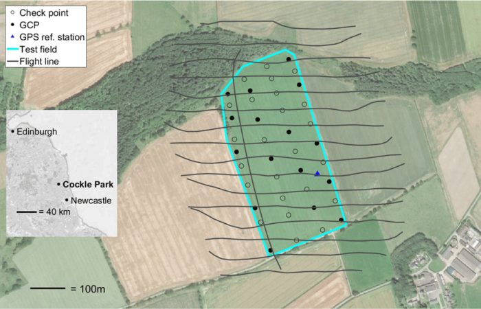
Using photogrammetry, where images are stitched and overlaid to create a relatively precise 3D map, researchers are increasingly using UAVs to map difficult to physically reach areas. However, there often is a need to use differential GPS, or DGPS, along with UAVs to create spatially accurate local maps. Using GPS precise point positioning (PPP), which can be attached to a UAV, precise maps can be made that are comparable to DGPS-based maps. Additionally, whereas before GCPs were needed to fix maps to a larger grid or projection system, the use of GPS PPP removes this need, enabling more remote regions to be more easily mapped. In standard mapping, ground control points are needed for creating accurate coordinates for maps; however, recent results suggest the use of PPP is on par with accuracy with that of post‐processed kinematic (PPK) techniques that help create maps. There is potential that elevation is not as accurate, although the error levels are relatively low (e.g., around 10 cm), making the technique still useful for most or many applications, with location data being within a few centimeters or less from the true point.[1]

Applications of GPS precise point positioning
In fact, PPP technology has become increasingly growing as the standard for GPS. This has led to mobile phone providers and phones, such as the Google Pixel 3 and Huawei Mate 20, to implement the technology in their latest phones.[2] The main limitation in using PPP has been the required processing power and time required to determine accurate location. This may become less of a limitation as processing chips, particularly using Graphic Processing Unit (GPU) technology, are enabling faster calculations and corrections to be made. This is not yet widespread but may mean that PPP will increasingly become more common as an important method for mapping.[3]
Potential application of PPP can go beyond simple mapping. Increasingly, providing more exact coordinates in flight and in real-time might be needed where information captured by UAVs can be sent back to controllers. For instance, in cases where UAVs are used to monitor swimmers or people in areas that could potentially put their lives in danger, UAVs with PPP could provide a more precise location where the given distress could be occurring, Faster processing time could enable a quicker reaction time to the precise location by rescue teams.[4] In studying climate science, mapping changing glaciers or remote regions in the Arctic and Antarctic might be required; however, a major limitation is the remoteness of these areas. This is also true in very mountainous regions that are rarely visited. Mounting PPP with UAVs can monitor more precisely how glaciers change, even at the centimeter level in regards to melting or movement of ice, where PPP location data can be streamed back to scientists monitoring ice change.[5]
What PPP potentially offers is a more accurate way to create maps and provide monitoring that can be used for a variety of purposes. With faster processing time, such mapping is proving to be potentially highly effective in areas where previously it was difficult to map due to limitations on GCP data. While such UAVs are not yet common, this could change in the next few years as scientists increasingly begin to apply technologies that enable faster processing and require equipment that monitors more remote areas.
References
[1] For more on using GPS PPP for mapping, see: Grayson B, Penna NT, Mills JP, et al. (2018) GPS precise point positioning for UAV photogrammetry. The Photogrammetric Record 33(164): 427–447. DOI: 10.1111/phor.12259.
[2] For more on the use of PPP with phones, see: Aggrey J, Bisnath S, Naciri N, et al. (2019) Multi-GNSS precise point positioning with next-generation smartphone measurements. Journal of Spatial Science: 1–20. DOI: 10.1080/14498596.2019.1664944.
[3] For more on PPP technology and its uses, see: Yang F, Zhao L, Li L, et al. (2019) Performance Evaluation of Kinematic BDS/GNSS Real-Time Precise Point Positioning for Maritime Positioning. Journal of Navigation 72(1): 34–52. DOI: 10.1017/S0373463318000644.
[4] For more on precision provided by PPP, see: Lygouras E, Santavas N, Taitzoglou A, et al. (2019) Unsupervised Human Detection with an Embedded Vision System on a Fully Autonomous UAV for Search and Rescue Operations. Sensors 19(16): 3542. DOI: 10.3390/s19163542.
[5] For more on monitoring ice sheets and glaciers using UAVs with PPP potential, see: Chudley TR, Christoffersen P, Doyle SH, et al. (2019) High-accuracy UAV photogrammetry of ice sheet dynamics with no ground control. The Cryosphere 13(3): 955–968. DOI: 10.5194/tc-13-955-2019.