
Much of the research literature on landscape change has focused on aerial imagery or satellite imagery from remote sensing sources. This is understandable if one were to look at wide areas. However, ground-level photographs also have great value to demonstrate landscape change from a human eye-level perspective. Combing such ground-level photographs with fieldwork and spatial analysis provides the possibility to assess human-environmental factors that have led to sometimes drastic change in the landscape.
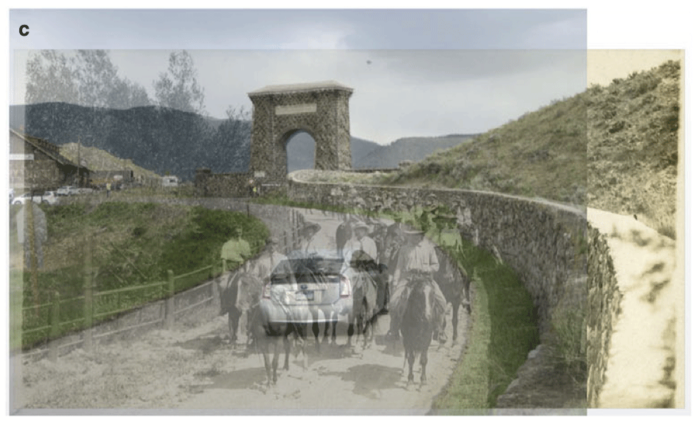
Yellowstone has become one of the most popular national parks in the United States. However, tourist experiences in this park have varied over time. In particular, using historical photographs and overlaying them on modern imagery taken using open source GNU Image Manipulation Program (GIMP), students were able to demonstrate that tourists would experience Yellowstone quite differently than 100 years ago. Trails that traversed hilly and mountainous views now offer different views as trees have grown and some areas have eroded, changing the perspective and view one would have from the ground level. Nevertheless, in many other areas, such as the train depot, that change was more minimal.[1]

Other tools have been created that help relate pixels in photographs and georeference them to real-world coordinates. For instance, the WSL Monoplotting Tool was developed in Switzerland to help not only reference photographs but it can also be used to relate georeferenced photographs with other forms of imagery. For instance, looking at historical photographs, one can reference these images, then overlay them with modern horizontal images, while also extracting satellite data, such as land use or vegetation classification, which then can be related to a given scene in a modern or old photographs of an area. This has benefits in showing landscape change over time using established classification of the landscape to demonstrate and quantify how much change is evident over time and where.[2]

In another study, the combination of historical aerial photographs from the 1930s, ground level images from the 1890s, and recent satellite and elevation data allowed the researchers to use structure-from-motion(SfM) techniques to georeference and create a digital elevation model (DEM) for glaciers. The DEM could be applied to the historical photographs so that even the ground level image from the 1890s could be reconstructed to demonstrate how tall and large the glacier was at a given point. This allows the researchers to study historical change and demonstrate where and what areas of a given glacier is melting at a greater rate.[3]
Landscape change, of course, is also complex. In some regions of Colorado and Wyoming, horizontal historical photographs and modern imagery are used to demonstrate that woodlands have increased since the 19thcentury in regions along these states. However, humans have modified much ofthe landscape and now new species are prevalent, such as Douglas-fir, where ponderosa pine once thrived. Imagery, in this case, can be compared to show the number of trees and change from photograph to photograph, where these photographs act as samples of the wider landscape.[4]
Historical ground-based imagery plays an important role in helping us to reconstruct our past environment. This, along with combinations of modern remote sensing data and ground-based images, can also help us to quantify changes going on around us to demonstrate effects of climate change or land use change. Popular techniques such as structure-from-motion or even tools such as GIMP can also us to combine historical and modern data to gain a clearer perspective of that change.
References
[1] For more information on how historical photographs can be overlaid to provide a ground-level perspective of landscape change in Yellowstone, see: Meyer, J. l., & Youngs, Y. (2018). Historical Landscape Change in Yellowstone National Park: Demonstrating the Value of Intensive Field Observation and Repeat Photography. Geographical Review, 108(3), 387–409. https://doi.org/10.1111/gere.12255.
[2] For more on using historical photographs and new images along with satellite for land classification, see: Stockdale, C. A., Bozzini, C., Macdonald, S. E., & Higgs, E. (2015). Extracting ecological information from oblique angle terrestrial landscape photographs: Performance evaluation of the WSL Monoplotting Tool. Applied Geography,63, 315–325. https://doi.org/10.1016/j.apgeog.2015.07.012.
[3] For more on the study using historical photographs to then help create a DEM, see: Mertes, J. R., Gulley, J. D., Benn, D. I., Thompson, S. S., & Nicholson, L. I. (2017). Using structure-from-motion to create glacier DEMs and orthoimagery from historical terrestrial and oblique aerial imagery: SfM on Differing Historical Glacier Imagery Sets. Earth Surface Processes and Landforms, 42(14), 2350–2364. https://doi.org/10.1002/esp.4188.
[4] For more on landscape and vegetation change in Colorado and Wyoming using historical photographs, see: Battaglia, M. A., Gannon, B., Brown, P. M., Fornwalt, P. J., Cheng, A. S., & Huckaby, L. S. (2018). Changes in forest structure since 1860 in ponderosa pine dominated forests in the Colorado and Wyoming Front Range, USA. Forest Ecology and Management, 422, 147–160. https://doi.org/10.1016/j.foreco.2018.04.010