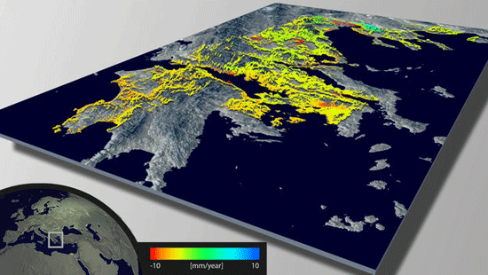
The European Space Agency has developed a new land data processor to create maps of land deformation. Called Wide Area Processor (WAP), the processes uses radar data to measure millimeter terrain deformations. Changes in the surface height of a landscape occur over time. Sinking of the earth can happen as a result of mining, earthquakes, or natural gas extraction. Expanding volcanoes or the collision between tectonic plates can result in the rising of the earth. The development of WAP allows for the measurement at the millimeter level of changes in the earth’s surface over large swaths of area.
Using a remote sensing technique called ‘persistent scatterer interferometry’, WAP is able to measure changes in height over time. Persistent scatterers are features such as buildings on the landscape that are stable, enduring, and reflect radar well. These characteristics present a measurable feature as the satellite orbits the earth.
For the pilot study, the WAP measured over a million persistent scatterers over half of Greece’s mainland (a land area of 65,000 km2) , pulling radar data from ERS-1 and ERS-2. Both of these remote sensing satellites house earth observation instruments including Synthetic Aperture Radar (SAR) which can detect changes in surface heights with sub-millimeter precision. With ERS-1 having orbited from 1991 to 2000, and ERS-2 still orbiting (launched in 1995), both earth observation satellites provide the ESA with long term data with which to study land deformation. For the initial study, over 360 gigabytes of raw radar data from the ERS-1 and -2 satellites was used. Rural areas averaged 10 scatterers per square kilometer. Urban areas such as the capitol, Athens, averaged 200 scatterers per square kilometer.
The study found that over a ten year period, areas in parts of Greece are sinking by about 10 mm per year. The areas of greatest subsidence were found in the cities Athens and Larissa, and around the Gulf of Corinth. The city of Thessaloniki showed areas experiencing both subsidence and uplift.

WAP can be used to process data from other satellites such as ALOS, TerraSAR-X and the future Sentinel-1. Sentinel-1 is being developed under Europe’s Global Monitoring for Environment and Security (GMES) program and will provide additional C-band synthetic aperture radar data. The first Sentinel-1 will be launched in 2013 and the second in a few years.
