
ESA

Mapping Heat Vulnerability from Satellite Data
Satellites are being used to measure heat not only on urban heat islands, but also on farms and other locations where rising temperatures are having an impact.

Remote Sensing of Lightning
Satellites and remote sensing tools are providing a way to better forecast and determine the severity of lightning.

Open-Source Science in the Cloud Collaboration
NASA and the European Space Agency (ESA) released a new open source and science tool called the Multi-Mission Algorithm and Analysis Platform (MAAP).

Satellite Imagery of the Widest River in the World
The Copernicus Sentinel-1 mission captured this satellite image of the Amazon river that has been processed by the combining of two polarisations into one image.

Understanding Ocean Wave Patterns from Satellite Imagery of Sun Glitter
Researchers have developed a method by which to translate satellite imagery of sun glitter on the water into data about the direction, height and movement of waves.

ESA’s Swarm Satellites Reveal Detailed Variations in the Earth’s Magnetic Field
Three years of data collection the European Space Agency's (ESA) Swarm satellites has resulted in the highest resolution map of Earth’s lithospheric magnetic field.

3.1-Trillion Pixel Landsat 8 Mosaic of the World
Descartes Labs has compiled some of the massive amount of data sent back from the satellites orbiting Earth into a 3.1-trillion pixel composite image of Earth’s surface.
Red Sprites and Blue Jets: Electrical Storms in the Upper Atmosphere
Known as red sprites and blue jets, these electrical storms shoot lightening up into space towards the outer edges of Earth's atmosphere instead of towards the surface of the Earth.

Learn How to Access and Use Sentinel-3 Data
Learn how to download and use earth observation data from ESA's Sentinel-3 satellite.

First Data Released From ESA Satellite Sentinel 3-A
The European Space Agency and Eumetsat have just released the first data from their new satellite platform, Sentinel 3-A. This groundbreaking new Earth observation platform can monitor a wide range of Earth systems, and will play a vital role in understanding our planet into the future.

Using Remote Sensing to Map Rice Paddy Drop in the Mekong Delta
Satellites including Europe’s Sentinel-1A can now track the rise and fall of different agricultural products around the world. The satellite’s imagery showed that rice production in the Mekong Delta has decreased in the past year.
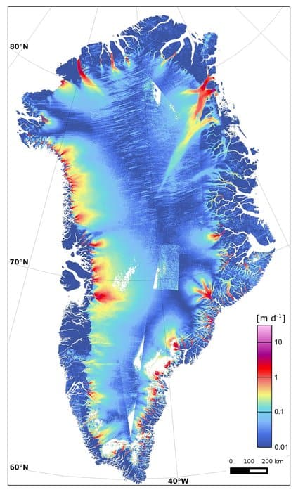
Ice Loss in Greenland
Recent research has shown that one of Greeland’s largest glaciers is losing up to five billion tons of ice every year as it melts into the ocean.

First Satellite Images from Sentinel-2 Delivered
Four days after its launch, the first images from Sentinel-2 have been delivered. Covering an area from central Europe and the ...

CryoSat Shows Record Loss of Polar Ice
Scientists concerned about climate change are closely monitoring the thickness of polar sea ice. For many years, ice cover has ...
Evaluating Ecosystems from Space
The ESA has launched their Space for Ecosystem project in order to more accurately evaluate the benefits of a natural resource.

How the Earth’s Magnetic Field is Changing
The ESA recently released the results of data collection from Swarm from the past six months that analyzed changes in the Earth's magnetic field.

Access CryoSat-2 Ice and Ocean Data Products
CryoSat-2 has been collecting data since its launch in 2010, allowing scientists to better understand changes in the thickness of polar sea ice, the elevation of the ice sheets that blanket Greenland and Antarctica, and mountain glaciers.
First Satellite Images from Sentinel-1A
Launched on April 3 and reaching operational altitude on April 11, the first images captured by the European Space Agency’s ...
Free and Open Access to Sentinel Satellite Data
The European Space Agency (ESA) has announced that free and open access to Sentinel satellite data will become available during ...

GOCE Gravity Mapping Mission Has Ended
GOCE, which stands The Gravity field and steady-state Ocean Circulation Explorer was launched with the purpose of mapping the Earth's gravity field at a high level of detail.

Mapping the Salinity of the Ocean
The European Space Agency (ESA) and the National Aeronautics and Space Administration (NASA) are mapping the salinity of the ocean to understand how the ocean helps recycle of our planet’s water resources and our climate.
Using Remote Sensing to Measure Land Deformation
The European Space Agency has developed a new land data processor to create maps of land deformation. Called Wide Area Processor ...

Measuring Earthquakes from Space
Up until recently, seismometers have been a strictly Earth-bound devices, diligently tracking each and every change in the Earth’s surface ...

Tracking Global Vegetation with Micro-Satellite Proba-V
The ESA, also known as the European Space Agency, has managed to do a lot of amazing feats in the ...
Armchair Geography
Geospatial technology has allowed users the ability to travel the world without ever leaving home. Users can explore the world, ...
Envisat Satellite Malfunctioning
Envisat, the European Space Agency’s (ESA) earth observation satellite, has stopped functioning properly. Communication with the satellite was lost on ...