
A.J. Rohn

Using Remote Sensing to Understand the Correlation Between Deforestation and Forest Fires
MAAP has used remote sensing to discover a correlation between deforestation and forest fires in Tampbopata, Peru.

Adapting to Live in a Hypersaline Environment
In their field work, the Iranian and French researchers encountered a Günther’s sea snake in the Persian Gulf, beyond what was thought to be its geographical range.

A Conservation-Based Future in Colombia
By properly including indigenous and impoverished peoples in the new economy and securing communal land rights in the forests, as well as fostering soil recovery in areas of coca cultivation and managing resource extraction, Colombia can move into a more equitable and environmentally sustainable future.

Microbial Life in Fracking Fluids
The introduction of fracking fluids very drastically changes the underground microbial ecosystems which become dominated by bacteria that thrive in highly saline environments including those of a new genus named Frackibacter.

EPA Issues Report on Fracking and Earthquakes
According to EPA scientists in North Texas, earthquakes there are likely related to fracking and drilling. Although it is not a new discovery that this link is possible or even likely, an acknowledgement from the EPA is significant.

Mangrove Ecosystems’ Importance and Vulnerability to Climate Change
Scientists in Australia have discovered that mangrove ecosystems in Queensland are dying at rates that have never been seen before.

Climate Explorer Tool Offers Local Climate Change Maps and Models
Climate Explorer is tool created by a collaboration of many federal agencies that allows users to explore future changes in temperature, precipitation, and heating and cooling days.

Antarctic Sea Ice Growth: A Climate Change Paradox
Over the course of the last few years, the growth of Antarctica’s sea ice was well documented while the Arctic has experienced ice melt. Different accounts have been given for the paradox at Earth’s poles.

Mountaintop Removal Mining and Flash Floods in West Virginia
Mountaintop removal mining is when explosives are used to blast through the peak of a mountain and expose coal that is buried below. The practice has destructive consequences on the trees of the mountain, as well as the streams.

Life Persists Around Chernobyl
Researchers are studying radiation's impact on wildlife and habitats in Chernobyl's exclusion zone.

The Complex Geography of the Brexit Vote
A.J. Rohn takes a look at the geographical factors behind the recent vote in the United Kingdom in favor of leaving the European Union in its controversial Brexit referendum.

Negotiations Underway at United Nations for Marine Protected Areas
The United Nations is currently developing regulations for ocean waters beyond national boundaries and exclusive economic zones, extending beyond 200 miles.

Fighting Drought with Man-made Mountains
As a major drought continues in Africa and the Middle East, the United Arab Emirates is considering a project to create a “man made mountain” and seed the resulting clouds in order to produce rainfall.

New Project Maps the Loss of Natural Spaces in American West
At DisappearingWest.org, you can actively monitor the loss of natural land as the American West continues to be developed with maps, statistics, and explanations for this trend.

Mapping the Consequences of American Urbanization and Stream Burial
A study has found that much of the area of urban America particularly in the Great Lakes region (8.3% of urban area), the Arizona Sun Corridor (7.1%), and Northern California (10.9%) but elsewhere all over the United States (6.2% total) are “urban stream deserts” in which a city is “riverless... due to the effects of human development and population growth”.
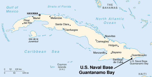
Call for a Guantanamo Bay Marine Research Facility and Peace Park
As Cuba hopes to be seen as environmentally aware and take action in conservation and many in the United States want to distance themselves from the reports of torture and international law violations in Guantanamo, the article in Science calls for the base to transition into a marine research facility.

A Promising Future in Global Fishery Management
Fisheries around the world are in peril, both ecologically and economically. According to a new analysis, that turmoil does not have to be permanent.

Eco-certification Trends in Fisheries
A recent study by researchers in Newfoundland and North Carolina looks at new trends in eco-certification and the attendant power dynamics between the parties engaged on a global scale.

Household Consumption Around the World
A new study quantifies national household consumptions to find which countries are most responsible for climate change based on consumption.

Google’s PlaNet: Geolocating Photos Using Artificial Intelligence
Google and researchers at the RheinischWestfälische Technische Hochschule Aachen University have developed an artificial intelligence system capable of identifying locations more consistently accurately than a human is able to do.

Geography and Racial Justice
Rashad Shabazz’s book "Spatializing Blackness" explores racial geographies' role in understanding slavery, segregation, and violence.

The Future of Jobs
Although the third industrial revolution (IR) is still progressing, and our world continues to be shaped in many ways by the results of the first two, the World Economic Forum has begun to refer to some developments happening now in cyberphysical systems as the fourth IR.

Addressing the United Nations’ Sustainable Development Goals
As part of the Shaping Davos series, one dialogue titled “A ‘Glocal’ Approach to Sustainable Development” addressed the United Nations’ sustainable development goals (SDGs).

Impacts of Dams on Biodiversity
A.J. Rohn discusses a report in Science which investigates the impacts of dams on the biodiversity of the Amazon, Congo, and Mekong river basins.

Tracking the Geographic Spread of the Zika Virus
For those that want to track the progression of the Zika virus, healthmap.org has an online map along with an interactive timeline to see the chronology of the virus starting with the first autochthonous case reported in the Americas on Easter Island, Chile.

Changes in Arctic Environments
Using remote sensing, a team of researchers is studying the fragile arctic environments of Northwest Siberia and how resource extraction and a warming climate affect vegetation, permafrost, and energy budgets.