
Maps and Cartography
Maps and cartography are essential tools in geography that enable us to visualize and understand the Earth’s surface and its features.
Cartography is the art and science of creating maps, which involves the use of sophisticated technology and techniques to accurately represent the Earth’s physical and cultural features.
Maps provide a visual representation of the world, allowing us to identify patterns, explore spatial relationships, and navigate through unfamiliar terrain.
Join the Crowdsourced Effort to Search for the Missing Malaysian Airlines Flight
Malaysian Airlines flight 370 disappeared on Saturday, March 8, 2014. The flight left Kuala Lumpur in Malaysia on March 8 ...

Cartographic Anomalies: How Map Projections Have Shaped Our Perceptions of the World
Elizabeth Borneman explores how cartography and cartographic projections help and hinder our perception of the world.

GPS Pet Trackers
The three most popular pet tracking GPS systems are reviewed in this article: the PetTronix RoamEO, Garmin GTU 10, and Tagg Pet Tracker.

Maps as People: Anthropomorphic Maps
Cartographers have been creatively crafting heads and bodies out of mountain ranges, coastlines, and other physical features. These anthropomorphic maps were intended mostly as propaganda pieces to show off the might of one country or stereotype foreign lands.

Submarine Cable Map
TeleGeography's 2014 Submarine Cable Map displays 285 existing or upcoming global cable systems by 2015.

How to Make Fantasy Maps
Interested in learning how to make fantasy maps? This five part tutorial from Jessica Khoury teaches users how to use Photoshop to make fantasy maps.

A Look at the Mercator Projection
Learn about the Mercator map projection – one of the most widely used and recently, most largely criticized projections. Amanda Briney takes a look at the history and development of the Mercator projection, how it works and some criticisms of the projection.

Mapping 92 Years of Bigfoot Sightings
Joshua Stevens has mapped out the location of Big Foot sightings in the United States.

Six Interesting Maps of 2013 (and One Graphic)
Everyone loves a great map. Maps engage readers and help them discover something they wouldn’t otherwise have learned about the ...
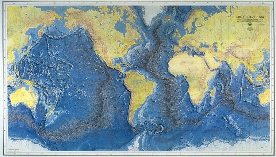
Marie Tharp and Mapping the Ocean Floor
As an oceanographic cartographer, Marie Tharp is credited with scientifically mapping the ocean floor in partnership with her colleague Bruce Heezen. Tharp and Heezen’s work was revolutionary, in that led to many discoveries and the theories of continental drift of plate tectonics. Tharp was a pioneer in science both as a woman and for her mapmaking.

Cartocacoethes
Cartocacoethes is a term meaning “a mania, uncontrollable urge, compulsion or itch to see maps everywhere.”

Mapping Global Events Since 1979
The Global Database of Events, Language, and Tone (GDELT) scours international news sources to catalogue georeferenced events occuring around the world.

Natural-color Shaded Relief Maps by Hal Shelton
Hal Shelton is a cartographer most notable for his natural-color maps done for Jeppeson Map Company in the 1950s and 1960s.

Dymaxion Map Projection
What makes the Dymaxion map project unique is that the Earth is projected onto the surface of an icosahedron, a polyhedron that is comprised of twenty triangular faces and thirty edges.

Elevation Map of Tweets
Twitter has release new maps to highlight just how prolific tweets are in London, San Francisco, and Istanbul. Building off ...

Maps for the North Challenged Coming to New York City
New York CIty is installing a network of pedestrian friendly maps in an effort called WalkNYC. The wayfinding maps will be "heads-up" so walker can easily orient themselves to the maps.

Largest Atlas in the World Created using ArcGIS
Earth Platinum, the largest atlas ever printed, was released in February 2012 by Millennium House, Australia. Only 31 copies of the 330 pound, leather-bound book exist and each are priced at $100,000. The atlas was created by the work of 88 cartographer and used ArcGIS.

Atlas of Design
Do you love beautiful maps? The Atlas of Design has been reprinted and is now available for purchase from the North American Cartographic Information Society (NACIS).

Exploring Map Projections
Created using D3, Map Projection Transitions provides an excellent way to visualize a wide range of map projections. The page ...


Crumpled Maps and Backward Globes
Palomar, an Italian company, innovates map and globe design with unique features like crumpled maps, Odnom globes, and pin city/world maps.
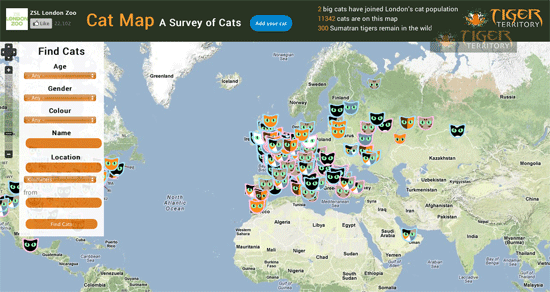
Cat Map
With over 11,000 cat locations mapped to date, the Cat Map is a crowd sourced survey of domestic feline

Map of Cardinals
Eligible cardinals from around the world are gathered in the Vatican for the papal conclave.

Map of the 2010 Census Using Dots
A map of the 2010 Census was created by Brandon Martin-Anderson, who assigned a dot to each of the 308,450,225 people counted.

Six of this Year’s Most Interesting Maps
Every year, there seems to be a handful of maps that fascinate the masses and fire up the social media platforms. Listed here are some of the more fascinating maps and GIS data visualizations that caught the public's attention in 2012.