
GIS Software
Information about GIS software and applications including both commercial and open source GIS applications. This category covers desktop GIS (Esri’s ArcGIS suite, MapInfo, QGIS, and GRASS) as well as web mapping, GIS apps, mobile GIS, and component GIS.

How to Share ArcMap (.mxd) Files
Learn how to set up your GIS data and symbol sets so that you can share ArcMap .mxd files with others.

Call for Translators: gvSIG
The developers of open source GIS software gvSIG have issued a call for translators. gvSIG is a freely downloadable GIS ...

3D Mapping with Google Smartphones
Project Tango is an initiative from Google that could revolutionize how the world is mapped and navigated.

GIS and Gaming
This article delves into the convergence of GIS and the video game industry, exploring their existing partnership and mutual benefits.

The Usability of a Web Mapping Application with a Million Rows of Data
Manuel Timita write about Illustreets, a web mapping application built with Open Source software, open data, and emerging GIS technologies (i.e. CartoDB).
ArcGIS Explorer vs. ArcGIS Online: A Side by Side Comparison
Two of Esri’s principal GIS viewing products, ArcGIS Explorer Desktop and ArcGIS Online, offer a variety of tools for both business and personal use. Tracey Dash takes a look at some of the key differences between the two programs.

Find Old GIS Software Programs
Take a walk down memory lane and find old GIS software programs hosted by the Internet Archive.

CyberGIS: The Next Frontier for GIS?
What is CyberGIS and how will it help advance the geospatial industry? Jack Pitts, a UK-based GIS Consultant, working in terrestrial and marine ecology, writes about the field of GIS is moving towards an Internet based solution.
QGIS 2.0 Released
A new release of QGIS, the popular open source GIS software has officially been released. Each version receives a name ...
Mapping the World Three Words at a Time
Instead of address and postal code, Chris Sheldrick has started a company that has divided the world into 57 trillion 3 meter ...
Make Maps in Excel with the New MAPCITE Version
MAPCITE has released a new version of its popular Excel spreadsheet mapping tool. The add-in allows users to visualize geographically ...

Add ArcGIS Online Maps to Your Wordpress Blog
A new plugin has just been released that gives those using Wordpress the ability to embed maps from ArcGIS Online ...

Developing Auditory Maps for the Blind
Human beings navigate through their environment by developing a mental understanding of spatial relationships known as a spatial cognitive maps. ...
Typefaces for National Geographic Maps
The National Geographic Society is renowned in part for its stunning maps, each labeled in incredible detail. The distinctive lettering ...
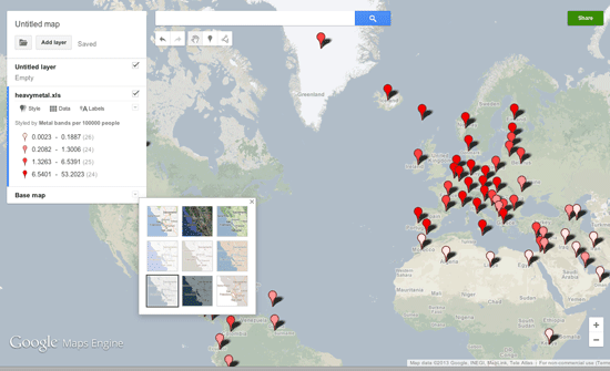
Make Your Own Maps with Google Maps Engine Lite
Google Maps Engine Lite is a simpler version of the Google Maps Engine that allows users to create and share their own maps.

Mapping Social Vulnerability
Oxfam America has released new maps about the geography and the people of the US Southeast, specifically Louisiana and Mississippi. This project ...

Converting Shapefiles to Google Fusion Tables
Learn how to import shapefile GIS data directly into Google Fusion tables.

Making Maps with D3
D3 is a JavaScript data visualization library using HTML, SVG and CSS. D3 stands for Data Driven Documents and was developed by Mike Bostock, ...

Wearable Cartography – Portable Mapping System
Researchers from MIT’s Computer Science and Artificial Intelligence Laboratory have developed a portal mapping system that transmits remotely a digital map ...

Twitter Map of the Last One Million Tweets
Want to see where the most recent one million geolocated tweets were posted from? The One Million Tweets Twitter map ...

Hurricane Sandy Maps with Open Data and GIS Publication Platforms
This guest submission by Chris Brown, CEO of MangoMap, takes a look at how open data and online GIS publication ...

Mapping Hurricanes
Information about embedable hurricane maps, historic hurricane tracks, and the top list of most damaging hurricanes from NOAA.
Dos and Don’ts of Web Map Design
The proliferation of easy to use tools and web services has brought web mapping a long way from its origins. ...
GeoSocial Interactive Map for Transportation Project Planning
This week a spectacular conference aimed towards transportation professionals is being held in Los Angeles called Rail~Volution. The aim of ...
Excel Mapping with ArcGIS Online
Esri recently debuted the availability of Esri Maps for Office, a new component of its ArcGIS Online service that allows ...
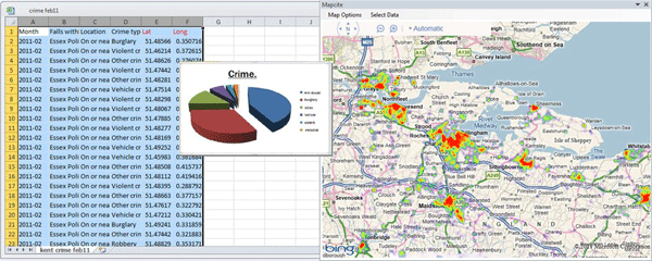
Making Maps With Excel
There is a huge amount of untapped geographic information stored within Microsoft Excel spreadsheets. With over one billion users of the popular spreadsheet software, that is a lot of data waiting to be mapped out. That said, the capability of mapping out that geographic data doesn't necessarily need to be done through an external desktop GIS software application. There are a few solutions on the market that provide both free and cost-based mapping solutions that operate directly within Excel.