
GIS Software
Information about GIS software and applications including both commercial and open source GIS applications. This category covers desktop GIS (Esri’s ArcGIS suite, MapInfo, QGIS, and GRASS) as well as web mapping, GIS apps, mobile GIS, and component GIS.

Styling Vector and Raster Data: Mastering QGIS
This section of the free chapter preview of Mastering QGIS looks at styling vector and raster GIS data in QGIS. Mastering QGIS is designed to bring ...

Adding Functionality with Plugins: Mastering QGIS
This section of the free chapter preview of Mastering QGIS looks at using plugins to extend the functionality of QGIS. Mastering QGIS is designed to bring ...

Composing Maps: Mastering QGIS
This section of the free chapter preview of Mastering QGIS looks at making maps in QGIS. Mastering QGIS is designed to bring users who want to go ...

Working with Tables: Mastering QGIS
This section of the free chapter preview of Mastering QGIS looks at working with tables in QGIS. Mastering QGIS is designed to bring users who want ...

Loading Data: Mastering QGIS
This section of the free chapter preview of Mastering QGIS covers loading different data types into QGIS desktop. Mastering QGIS is designed to bring users who want ...
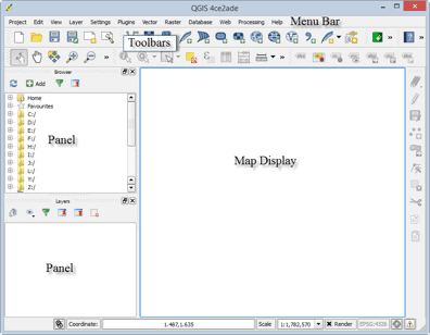
Tour of QGIS: Mastering QGIS
This section of the free chapter preview of Mastering QGIS covers the graphical user interface components of both QGIS Desktop and QGIS Browser. Mastering QGIS is ...

QGIS Download and Installation: Mastering QGIS
This section of the free chapter preview of Mastering QGIS covers downloading and installing QGIS. Mastering QGIS is designed to bring users ...

Learn about GIS in the Cloud
GIS technology and processing in the cloud is on the way to becoming the next big trend. The various functionalities of the cloud can be suitably tailored to fit into an organization’s geospatial workflow.


Solving Field GIS Wireless Connectivity Issues with Web Apps
WebMapSolutions enhances offline GIS capabilities in the browser by integrating JavaScript widgets that extend functionality in any web app.

Free Field Survey Tools
With the immense leaps of cheaper data storage, cellular availability, and awareness toward open source components, the options to create ...

Using GIS to Identify Milwaukee’s Homeless Population
GIS Cloud has developed a mobile GIS and mapping app that allows for the collection of information about homeless populations in the City of Milwaukee in Wisconsin.

GISconnector for Excel – Synchronize Data, Selections, and Filters between ArcGIS and Excel
A new tool is available called GISconnector for Excel which enables bidirectional data transfer between ArcGIS and Excel. The tool, GISconnector, also ...

Disconnected Editing with ArcGIS in the Browser
Matt Sheehan discusses disconnected editing for ArcGIS and the libraries that Web Map Solutions has developed to provide users with disconnected capabilities to any ArcGIS web app in the browser.

Focusing GIS Apps on the User’s Needs
Timmons Group's Lowell Ballard stresses the importance of preventing scope creep in GIS app development to keep them focused and user-friendly.

Generalization in GIS
Generalization is the method used in GIS to reduce detail in data. Learn about how to generalize GIS data using QGIS, ArcGIS, and other software tools.

Latest Release of MapInfo Focuses on an Easier to Use Mapping Experience
Pitney Bowes, the maker of MapInfo, has released an updated version of the GIS software that is aimed towards lowering ...

Finding Low Tech Solutions for Nairobi’s Commuters
How do you help commuters navigate traffic when only 19% of the population owns a smartphone? IBM's Nairobi Labs has released a solution for commuters that uses low resolution traffic cameras to predict traffic patterns that are relayed via SMS.
QGIS versus ArcGIS
When considering which GIS desktop software to adopt, two of the most popular choices are Esri’s ArcGIS and Quantum GIS, ...

GIS in Social Science: Mapping Social Capital Strength to Measure Organizational Efficacy
Here are four steps to use GIS in measuring social capital of social service programs, improving understanding of organizational effectiveness and conducting gap analysis.

Five Ways to Use GIS to Strengthen Your Nonprofit Fundraising
Here are five ways GIS can improve nonprofit fundraising, from refining prospect pools to partnerships, storytelling, and evaluation.

Searchable Database of Coordinate Systems
If you need a consolidated place to search for coordinate systems, EPSG.io is a place to start.

Planning with Google Earth – A Cost-Effective Alternative
Rick Tralies of the Natural Lands Trust, explains how organizations and non-profits can use Google Earth as a planning and mapping tool.

OWGIS – Open Source GIS Web Application
Standing for Open WebGIS, the developers of OWGIS describe it as an “OpenSource Java Servlets web application that creates WebGIS sites ...

Where is the Cloud in GIS for Watershed Management?
Barbara Horvatic, the Marketing Manager at GIS Cloud, explains how using a cloud-based GIS can help create a collaborative environment ...

Esri Releases Explorer for ArcGIS for Mac OS
Data viewer from Esri for MacOS which offers limited functionality to "access maps, search for and visualize data."