
Maps and Cartography
Maps and cartography are essential tools in geography that enable us to visualize and understand the Earth’s surface and its features.
Cartography is the art and science of creating maps, which involves the use of sophisticated technology and techniques to accurately represent the Earth’s physical and cultural features.
Maps provide a visual representation of the world, allowing us to identify patterns, explore spatial relationships, and navigate through unfamiliar terrain.

Post-Election Maps for the 2012 Presidential Election
A look at some of the more insightful post-election maps from the 2012 presidential race.

Best Election Maps
With every major news outlet hosting some form of a 2012 Presidential election map, what are the best election maps ...
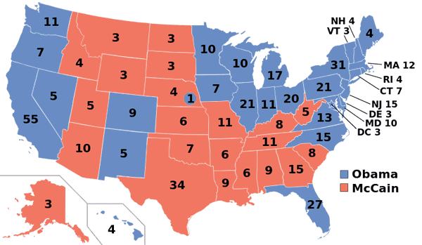
Presidential Election Maps from 1968 to 2012
Listed here are the presidential election maps for each the past eleven elections spanning 1968 to 2012. The maps show the breakdown of electoral college votes by state.

Baseball Maps and GIS
So how do cartography and baseball mix? Check out these interesting examples of baseball maps.

Geography of Coffee
To geographers, coffee holds a number of intriguing chronicles relating to physical geography, human geography, biogeography, and many other aspects.

Time and GIS: Ways of Representing Time on a Map
Spatialtemporal visualization are ways to illustrate changes in an area over time on a map. The famous geographer Immanuel Kant maintained that geography was the study of knowledge in a location, while history was the study of knowledge in time. This article explores different cartographic methods of showing changes in time over space on a map.
Hurricane Isaac Mapped
Projected to make landfall tonight at the southwest pass of the Mississippi River, a recently reclassified Hurricane Isaac has a lot ...

Map Theft and Map Thieves
As with most objects that carry a potentially large price tag, rare and valuable maps have been subjected to theft ...
Map as Art
There are many amazing examples of artists who turn to cartography and geography for inspiration. Whether through the lens of ...

How To Make Area Cartogram Maps in ArcGIS
If you have data with disparate values between areas, making an area cartogram is an effective way to map out those values. This article provides a tutorial on how to make area cartogram maps using ArcGIS.

Interactive Maps of Billionaires
Three interactive maps showing the locations of billionaires around the world.

Area Cartogram Maps Explored
Area cartogram maps are maps of non-absolute space where the areal extent is in proportion to some measured value. Cartogram ...

Mapping Emancipation Events during the Civil War
"Visualizing Emancipation," the first interactive map showing the end of American slavery during the U.S. Civil War, has been launched by the University of Richmond’s Digital Scholarship Lab in partnership with geospatial analysis (GIS) software development company Azavea.
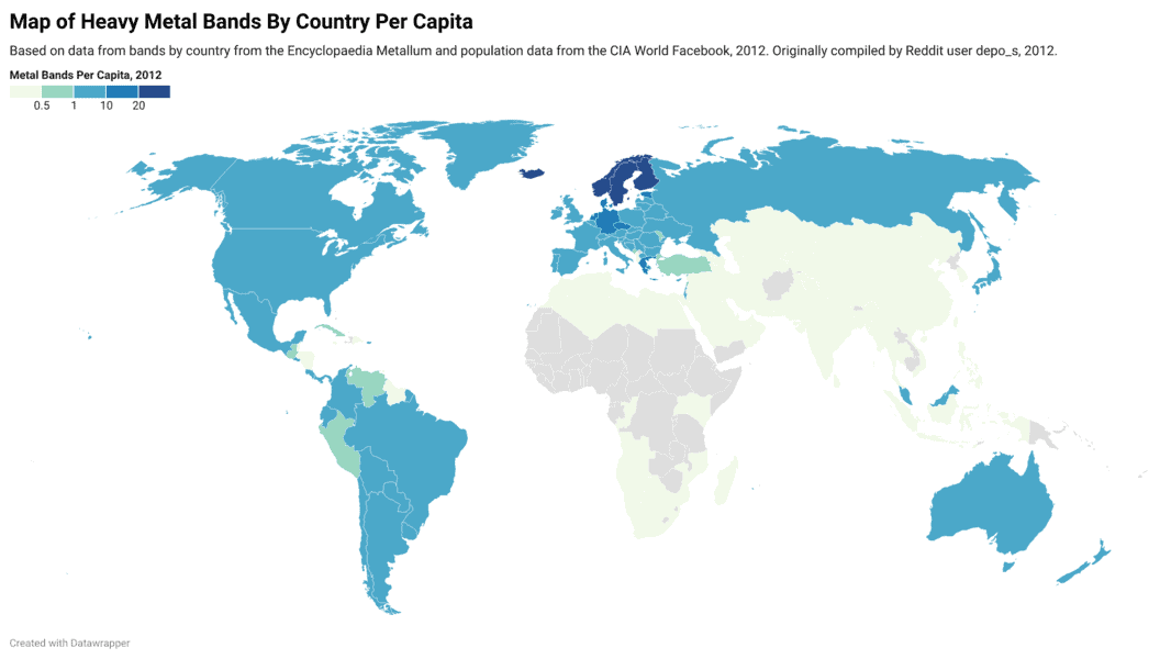
Interactive Map of Heavy Metal Bands By Country Per 100,000 People
Map and table showing where heavy metal bands are the most dense when compared against a country's total population.

Mapping the World at Night
Earth observation satellites are tracking nighttime lights around the world.
Ultima IV Map Exhibition Preparation – GIS in Imagery Series
The Smithsonian American Art Museum is featuring an exhibition entitled The Art of Video Games which is set to run ...
What is Ethno Mapping?
Maps aren’t just intended for navigation. Though most people think of maps in terms of what kind of physical land ...

Google Ancient Places: Exploring the Geography of Ancient Places in Text
GapVis (Google Ancient Places Visualization) allows readers the ability to geographically explore text covering ancient places. The endeavor is backed ...

Where to Look for Historical Maps
The use of extracting data from old paper maps is growing in popularity as a method to understanding historical geography. ...
Essential Geography of the United States Mapped
Dave Imus is a well known cartographer who has specialized in highly detailed, hand annotated maps covering the United States. ...

Ptolemy’s Geographia
Ptolemy was not only a geographer but a mathematician, astronomer, astrologer, and even a poet.

Fusing Fine Art with Cartography
David McCarter's cartography infuses fine art with map making to create colorful maps.
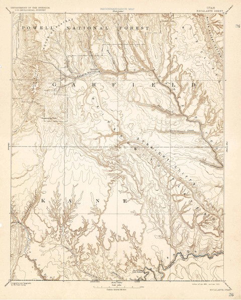
Over 120 Years of Mapping History Online
The USGS Historical Topographic Map Collection currently makes over 98,000 maps dating as far back as 1884 available to the public.

Ten Things to Consider When Making a Map
Here are ten common considerations that all cartographers should incorporate as part of their map making process.

Enhancing Shorelines with Vector-Based Coastal Vignettes
Creating coastal vignettes using GIS or mapping software is a cartographic technique that adds depth to open water on a map.
Mapping Through the Ages: The History of Cartography
The fascination and interest for the world that we inhabit, has been inherent to human nature since prehistoric times. Some ...