
Security software applications have traditionally been built around monitoring through close-circuit television (CCTV) and related software that integrates cameras to observe and detect potential security threats. The use of GIS, however, allows greater enhancements not just to monitoring but also planning and forecasting potential security threats, both from physical and cyber threats.
The field of Physical Security Information Management has seen large growth in the last two decades as security interests have increased. Software responses have included many companies creating platforms that work to integrate various sources of data, including CCTV, life critical systems, radar, sensor, and GPS data from field sites. Platforms such as CNL is one example of how industry has adjusted to the need of integrating multiple data feeds where also software facilitates automated alerts and detection of potential threats, such as encroachment of a secured area, through analytics that look at motion and potential intent.[1]
Proactive Security Measures and GIS
One focus area is to also improve security before incidents happen. This can be done through applications that integrate potential user data from, for example, exit points and pathways, which include how mobile people are, that then allow customized information to be provided to enable escape from buildings or areas in cases when an event occurs.
In the CE4Blind project, a GIS was created that allowed users to provide data, through their smart phones, which integrate into a hierarchical layering system with other data that feeds and customises appropriate data for the person (e.g., a disabled person) so that they are aware of exit points that best suit their needs in cases of emergency.[2]

Walkability and Safety
While growth in improving site and multi-site security has led to increased use of GIS with more traditional security monitoring and analysis, other forms of security assess wider regions as a whole. For instance, in the Greater Manchester area, improving walkability was an objective in one project. However, some areas where residents are encouraged to walk more also attract high crime. Using a Geographic Information Systems for Participation approach, that integrates viewpoints and perceptions of individuals in the study area, better walking routes that factor community health and safety together were developed. The intent was also to help facilitate economic growth by making areas more attractive for people to walk to, effectively helping to revive the community.[3]
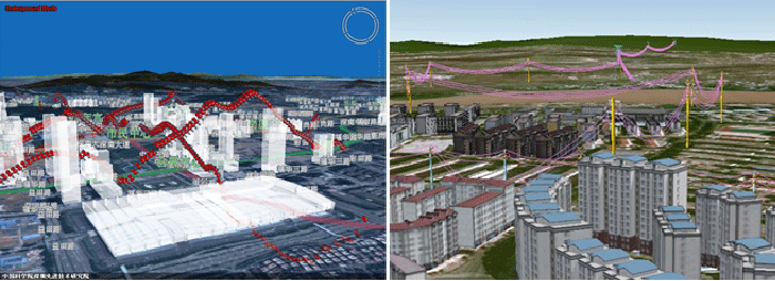
Urban Security
Software has also looked at urban security in large cities. Integrating different security data with other information, such as traffic, residential data, and building data has led to the creation of platforms such as XEarth, which provides 3D visualization technology of live data patterns to aid in areas of security and other planning.
Tools such as this focus on Geographic human-computer interaction that provide information to the user and some analytical capability to aid in decision-making.[4]

Cybersecurity and Geospatial Technologies
Cybersecurity has been one of the largest areas seeing growth as the rise of GIS and security has occurred. In particular, attacks against critical infrastructure, such as electrical power systems, has been an important vulnerability area addressed by GIS applications.
For example, electricity providers often depend on demand estimates that balances and provides electricity where it is most needed. Cyber attacks could provide false data to electric decision-makers, leading to improper balance of energy and outages.
Detection software has used GIS power grid mapping to monitor distribution of energy but also security detection algorithms have been integrated to detect anomalies in the distribution load that detects if false information is likely being sent to operators. The intent is to find anomalous feeds relative to distribution loads and decisions being undertaken. This has formed part of the smart-grid applications that have been in active development over the last decade.[5]
What we see is that software increasingly utilises GIS methods or applications with both traditional security tools, such as CCTV, but also with other new forms of data for a variety of applications. This not only helps improve security but also allows anticipation and planning to be more easily done for physical security threats but also cyber security on areas such as critical infrastructure.
References
[1] For an example of security software that work to integrate multiple data and analytics, see: https://www.cnlsoftware.com/.
[2] For more on the CE4Blind project, see: Fernandes, H., Teixeira, R., Daniel, B., Alves, C., Reis, A., Paredes, H., … Barroso, J. (2017). Design of Geographic Information Systems to Promote Accessibility and Universal Access. In M. Antona & C. Stephanidis (Eds.), Universal Access in Human–Computer Interaction. Human and Technological Environments(Vol. 10279, pp. 291–299). Cham: Springer International Publishing. https://doi.org/10.1007/978-3-319-58700-4_24.
[3] For more on the study that looked at walkability and safety, see: Schofield, P., Doran, A., and Nolan, R. (2017). Assessing the walkability of urban public space with GIS technology: The hidden dimensions of security and community heritage. In: The Routledge international handbook of walking. Abingdon, Oxford, Routledge, 369-378.
[4] For more on XEarth, see: Li, X., Lv, Z., Hu, J., Zhang, B., Shi, L., & Feng, S. (2015). XEarth: A 3D GIS platform for managing massive city information. In 2015 IEEE International Conference on Computational Intelligence and Virtual Environments for Measurement Systems and Applications (CIVEMSA)(pp. 1–6). Shenzhen, China: IEEE. https://doi.org/10.1109/CIVEMSA.2015.7158625.
[5] As an example of electricity distribution using cyber security and GIS together, see: Zhou, C., Feng, R., Wang, L., Huang, W., & Guo, Y. (2017). Security attack detection algorithm for electric power gis system based on mobile application. IOP Conference Series: Earth and Environmental Science, 64, 012101. https://doi.org/10.1088/1755-1315/64/1/012101.