

Generating a talented workforce is not only a goal for corporations but also cities around the world that want to increase their economic potential and contribute a viable tax base to build exciting places.
This has also meant using GIS tools to see how well their cities are able to attract young talent. One measure cities want is how walkable their city is or how easy pedestrians can access everyday needs, including restaurants, shops, and essential services.
What is walkability
Walkability is a measure to see how friendly an area is for walking by looking at what is around an area and how easy it is to reach them simply by walking. Walkability scores have been around for some time.
Since 2007, the company Walk Score has existed, which has produced spatial analysis in countries such as the United States, Canada, and Australia. The service was initially created to help mobile individuals, often young professionals, find places in cities where they would find it liveable and convenient to walk to different areas.
In 2014, the company was bought by Redfin and is now part of their services. The core analysis uses an automated efficiency model, which looks at location efficiency in accessing services based on how long it takes to access services using roads and areas one can walk.[1]
Open source walkability tools
Tools to compute pedestrian accessibility are not just available to governments, academics, or companies, but are also free and open source.
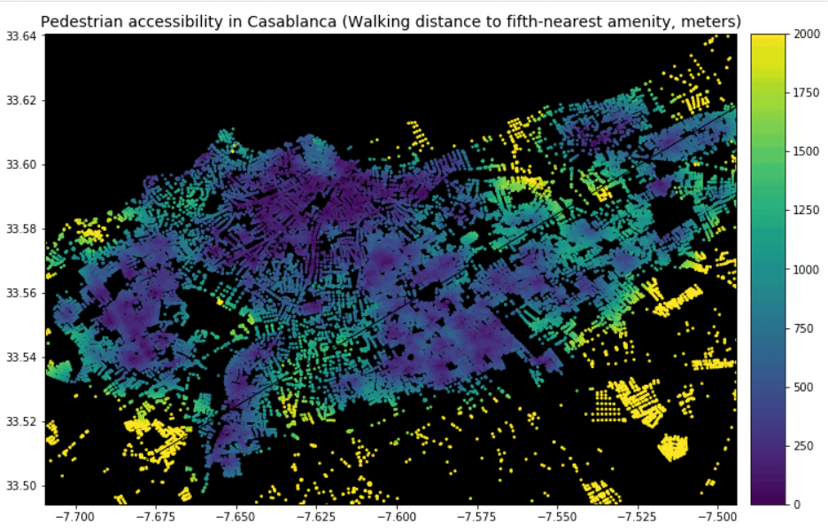
One tool that is freely available is the Python tool Pandana, which can be downloaded from GitHub. The basic approach of this tool is it looks at street networks as graphs of links and nodes, where distance based on walking can be calculated based on accessibility of different nodes via street links.
Areas that are nearer to more points of interest have a higher score and are more pedestrian friendly. Users can modify the approach to look at one or more specific types of services, such as schools or access to markets.
Effectively, the approach is similar to Walk Score’s automated efficiency model that looks at location efficiency of accessing places. Different amenities or services can be weighed differently.
For instance, easily accessing entertainment might be more important than accessing a laundromat for some. The analysis could be extended to cover the entire city. This divides the city into relevant areas that are aggregated in the analysis or assessed individually.
The overall result gives a walking score or allows users to know if given neighbourhoods are more accessible.[2]
The assessment of how friendly to walking places are is not new. In fact, among the earliest people to see the benefits of calculating walkability for urban environments were healthcare researchers and those researching the built environment, who were interested in seeing how easy it was to walk in different regions.
Research had created databases in cities and measured friendliness of given areas to physical activity with walking being one of the key factors measured as it was among the most common physical activity people would normally do during their day.
This has been used to help researchers propose different ways in which cities or neighbourhoods could be designed to improve accessibility, walkability, and encourage more physical activity.[3]
Interesting new ways in which this type of work is being applied in research is how walkability in cities is now being linked with other phenomena. For instance, areas that are often less walkable also tend to be impoverished or have other social problems.
There is clear evidence that social inequality and walkability seem to have a link. In effect, not all neighbourhoods have the easy option of upgrading or making their areas more accessible, in part because there are larger economic and social factors influencing planning and policy.
What this could mean is that tools that encourage migration to more walk-friendly areas could also help exacerbate social inequality, as greater investment in businesses and accessibility follows wealthier individuals rather than individuals who might currently live in a neighbourhood with more limited walking access.
This can create a viscous cycle of diminishing access to services while also minimizing access to physical activity, for some at least, that could be healthier for the individual.[4]
Cities will increasingly seek to make their neighbourhoods more walkable and friendly to pedestrians. This is in part to cater to young professionals who seek such places but also it has the benefit of minimizing traffic, reducing pollution, and improving the overall health of citizens while benefiting the tax base of cities by preventing out migration.
While tools such as Walk Score and Pandana now enable anyone to assess how walkable places are, there can be a downside to this as investment increasingly flows to specific areas. Tools such as Pandana could also be used for planning purposes, one that estimates how a place could change rather than how it currently is friendly to walking.
With such planning, cities could also begin to benefit a broader breadth of their citizens by focusing on wider accessibility.
References
[1] For more on Walk Score, see: https://www.walkscore.com/
[2] For more on an assessment of Pandana, see: https://towardsdatascience.com/measuring-pedestrian-accessibility-97900f9e4d56. More code and functional information on Pandana can be accessed at: https://udst.github.io/pandana/introduction.html#contributing-to-pandana.
[3] For an example paper on calculating walkability, physical activity potential in places, and using databases for the built environment, see: Leslie, E., Coffee, N., Frank, L., Owen, N., Bauman, A., & Hugo, G. (2007). Walkability of local communities: Using geographic information systems to objectively assess relevant environmental attributes. Health & Place, 13(1), 111–122. https://doi.org/10.1016/j.healthplace.2005.11.001
[4] For more on social inequality and walkability, see: Su, S., Zhou, H., Xu, M., Ru, H., Wang, W., & Weng, M. (2019). Auditing street walkability and associated social inequalities for planning implications. Journal of Transport Geography, 74, 62–76. https://doi.org/10.1016/j.jtrangeo.2018.11.003